Weekly Edition 52 of 2012
Weekly Edition 52 of 2012
Weekly Edition 52 of 2012
You also want an ePaper? Increase the reach of your titles
YUMPU automatically turns print PDFs into web optimized ePapers that Google loves.
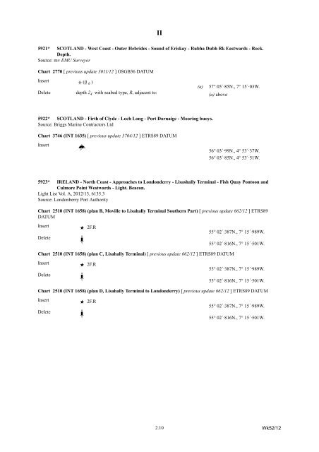
5921* SCOTLAND - West Coast - Outer Hebrides - Sound <strong>of</strong> Eriskay - Rubha Dubh Rk Eastwards - Rock.<br />
Depth.<br />
Source: mv EMU Surveyor<br />
Chart 2770 [ previous update 3011/12 ] OSGB36 DATUM<br />
Insert ³ (0 6 )<br />
Delete depth 2 4 with seabed type, R, adjacent to:<br />
5922* SCOTLAND - Firth <strong>of</strong> Clyde - Loch Long - Port Dornaige - Mooring buoys.<br />
Source: Briggs Marine Contractors Ltd<br />
II<br />
2.10<br />
(a) 57° 05´·85N., 7° 15´·03W.<br />
(a) above<br />
Chart 3746 (INT 1635) [ previous update 3704/12 ] ETRS89 DATUM<br />
Insert Rf 56° 03´·99N., 4° 53´·37W.<br />
56° 03´·85N., 4° 53´·51W.<br />
5923* IRELAND - North Coast - Approaches to Londonderry - Lisashally Terminal - Fish Quay Pontoon and<br />
Culmore Point Westwards - Light. Beacon.<br />
Light List Vol. A, <strong>2012</strong>/13, 6135.3<br />
Source: Londonberry Port Authority<br />
Chart 2510 (INT 1658) (plan B, Moville to Lisahally Terminal Southern Part) [ previous update 662/12 ] ETRS89<br />
DATUM<br />
Insert · 2F.R<br />
55° 02´·387N., 7° 15´·989W.<br />
Delete KlÜ<br />
55° 02´·816N., 7° 15´·501W.<br />
Chart 2510 (INT 1658) (plan C, Lisahally Terminal) [ previous update 662/12 ] ETRS89 DATUM<br />
Insert · 2F.R<br />
55° 02´·387N., 7° 15´·989W.<br />
Delete KlÜ<br />
55° 02´·816N., 7° 15´·501W.<br />
Chart 2510 (INT 1658) (plan D, Lisahally Terminal to Londonderry) [ previous update 662/12 ] ETRS89 DATUM<br />
Insert · 2F.R<br />
55° 02´·387N., 7° 15´·989W.<br />
Delete KlÜ<br />
55° 02´·816N., 7° 15´·501W.<br />
Wk<strong>52</strong>/12


