

Weekly Edition 52 of 2012
Weekly Edition 52 of 2012
Weekly Edition 52 of 2012

You also want an ePaper? Increase the reach of your titles
YUMPU automatically turns print PDFs into web optimized ePapers that Google loves.
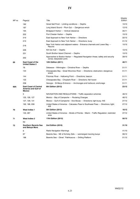
NP no<br />
Page(s)<br />
Title<br />
IV<br />
4.23<br />
<strong>Weekly</strong><br />
<strong>Edition</strong><br />
182 Great Salt Pond – Limiting conditions — Depths 10/10<br />
187 Long Island Sound – Plum Gut — Dangerous wreck 12/10<br />
194 Bridgeport Harbor — Vertical clearance 35/11<br />
202 Port Chester Harbor — Depths 10/10<br />
210 East Approach to New York Harbor — Directions 32/12<br />
210 East Approach to New York Harbor — Directions; buoy 31/12<br />
216<br />
New York Harbor and adjacent waters – Entrance channels and Lower Bay —<br />
Racons<br />
226 Kill Van Kull — Depths 10/10<br />
231 South Brother Island Channel — Depths 10/10<br />
2<strong>52</strong><br />
Approaches to Boston Harbor — Regulated Navigation Areas; safety and security<br />
zones; deepwater ports<br />
69 East Coast <strong>of</strong> the<br />
United States 2<br />
12th <strong>Edition</strong> (2011) 49/11<br />
78 Delaware – Wilmington – Christina River — Depths 51/11<br />
134 Chesapeake Bay – Great Wicomico River — Directions; obstruction; dangerous<br />
wreck<br />
144 Potomac River – Hallowing Point — Directions; beacon 51/11<br />
150 Chesapeake Bay – Choptank River — Directions; fish haven 51/11<br />
236 Georgia – St Marys Entrance — Anchorages and harbours; anchorage 51/11<br />
69A East Coast <strong>of</strong> Central<br />
America and Gulf <strong>of</strong><br />
Mexico<br />
6th <strong>Edition</strong> (<strong>2012</strong>) 23/12<br />
5 NAVIGATION AND REGULATIONS – Traffic separation schemes 46/12<br />
125, 126, 127 Mexico – Bay <strong>of</strong> Campeche — Routeing Changes 46/12<br />
127, 129, 131 Mexico – Gulf <strong>of</strong> Campeche – Dos Bocas — Directions; light buoy; AIS 27/12<br />
192, 196, 209 United States <strong>of</strong> America – Calcasieu Pass to Southwest Pass — Directions; light;<br />
AIS<br />
70 West Indies 1 5th <strong>Edition</strong> (<strong>2012</strong>) 18/12<br />
130, 287 United States <strong>of</strong> America – Straits <strong>of</strong> Florida – Miami – Traffic Regulation; restricted<br />
area<br />
37/12<br />
71 West Indies 2 17th <strong>Edition</strong> (<strong>2012</strong>) 50/12<br />
Nil<br />
72 Southern Barents Sea<br />
and Beloye More<br />
10/10<br />
39/10<br />
51/11<br />
27/12<br />
2nd <strong>Edition</strong> (2010) 31/10<br />
6 Radio Navigation Warnings 41/10<br />
67 Barents Sea – NE <strong>of</strong> Kol’skiy Zaliv — submerged mooring buoys 06/12<br />
186 Barents Sea – Otmel ’ Pakhtusova — Drilling Platform 01/12<br />
Wk<strong>52</strong>/12


