Weekly Edition 52 of 2012
Weekly Edition 52 of 2012
Weekly Edition 52 of 2012
You also want an ePaper? Increase the reach of your titles
YUMPU automatically turns print PDFs into web optimized ePapers that Google loves.
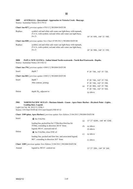
5889 AUSTRALIA - Queensland - Approaches to Victoria Creek - Buoyage.<br />
Source: Australian Notice 24/1179/12<br />
Chart Aus 827 [ previous update 4703/12 ] WGS84 DATUM<br />
Replace symbol, red and white safe water can light-buoy with topmark,<br />
Fl.4·3s, with symbol, red and white safe water can light-buoy,<br />
Iso.2s 18° 36´·89S., 146° 21´·50E.<br />
Chart Aus 828 [ previous update New Chart 07/09/<strong>2012</strong> ] WGS84 DATUM<br />
Replace symbol, red and white safe water can light-buoy with topmark,<br />
Fl.4·3s, with symbol, red and white safe water can light-buoy,<br />
Iso.2s 18° 36´·90S., 146° 21´·55E.<br />
5890 PAPUA NEW GUINEA - Saibai Island North-westwards - North Reef Eastwards - Depths.<br />
Source: Australian Notice 24/1182/12<br />
Chart Aus 376 [ previous update 4360/12 ] WGS84 DATUM<br />
Insert depth 7 9° 20´·74S., 142° 35´·72E.<br />
Chart Aus 841 [ previous update 4360/12 ] WGS84 DATUM<br />
Insert depth 7 9° 20´·74S., 142° 35´·72E.<br />
10m contour, joining: 9° 20´·74S., 142° 35´·59E.<br />
(a) 9° 20´·90S., 142° 35´·70E.<br />
9° 20´·74S., 142° 35´·92E.<br />
Delete depth 285, adjacent to:<br />
(a) above<br />
5901 NORTH PACIFIC OCEAN - Mariana Islands - Guam - Apra Outer Harbor - Drydock Point - Lights.<br />
Leading lines. Legend.<br />
Light List Vol. M, <strong>2012</strong>/13, 8386.1<br />
Source: US Chart 81054 & US Coast Guard LNM 45/12<br />
Chart 1109 (plan, Apra Harbor) [ previous update New <strong>Edition</strong> 21/04/2011 ] WGS84 DATUM<br />
Insert Iso.Y.6s25m<br />
(a) 13° 27´·424N., 144° 40´·329E.<br />
leading line, pecked line for 1720m then firm line for<br />
5530m, extending in direction 263·6° from: (b) (a) above<br />
Delete<br />
legend, 083·6°, seaward end <strong>of</strong>:<br />
Iso.Y.6s20m, close ENE <strong>of</strong>:<br />
leading line, pecked and firm line, and associated legend,<br />
(c)<br />
(b) above<br />
(a) above<br />
083°, extending in direction 263° from: (c) above<br />
II<br />
Chart 1109 [ previous update New <strong>Edition</strong> 21/04/2011 ] WGS84 DATUM<br />
Amend legend to, 083·6°, centred on: 13° 27´·28N., 144° 38´·26E.<br />
Wk<strong>52</strong>/12<br />
2.45


