Scottish Road Network Landslides Study - University of Glasgow
Scottish Road Network Landslides Study - University of Glasgow
Scottish Road Network Landslides Study - University of Glasgow

Create successful ePaper yourself
Turn your PDF publications into a flip-book with our unique Google optimized e-Paper software.
42<br />
INFORMATION SOURCES<br />
Limitations: It is acknowledged that some misclassification <strong>of</strong> the land use will have been<br />
made at the time <strong>of</strong> survey but this is thought to be relatively minor in nature. Also, the<br />
dataset was based on 1990 information and it is possible that the land use has changed since<br />
that time<br />
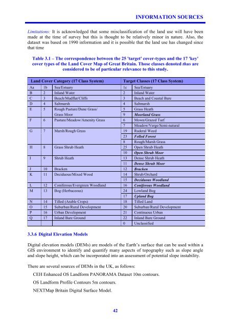
Table 3.1 – The correspondence between the 25 'target' cover-types and the 17 'key'<br />
cover types <strong>of</strong> the Land Cover Map <strong>of</strong> Great Britain. Those classes denoted thus are<br />
considered to be <strong>of</strong> particular relevance to this study.<br />
Land Cover Category (17 Class System) Target Classes (17 Class System)<br />
Aa 1b Sea/Estuary 1c Sea/Estuary<br />
B 2 Inland Water 2 Inland Water<br />
C 3 Beach/Mudflat/Cliffs 3 Beach and Coastal Bare<br />
D 4 Saltmarsh 4 Saltmarsh<br />
E 5 Rough Pasture/Dune Grass/ 5 Grass Heath<br />
Grass Moor 9 Moorland Grass<br />
F 6 Pasture/Meadow/Amenity Grass 6 Mown/Grazed Turf<br />
7 Meadow/Verge/Semi-natural<br />
G 7 Marsh/Rough Grass 19 Ruderal Weed<br />
23 Felled Forest<br />
8 Rough/Marsh Grass<br />
H 8 Grass Shrub Heath 25 Open Shrub Heath<br />
10 Open Shrub Moor<br />
I 9 Shrub Heath 13 Dense Shrub Heath<br />
11 Dense Shrub Moor<br />
J 10 Bracken 12 Bracken<br />
K 11 Deciduous/Mixed Wood 14 Shrub/Orchard<br />
15 Deciduous Woodland<br />
L 12 Coniferous/Evergreen Woodland 16 Coniferous Woodland<br />
M 13 Bog (Herbaceous) 24 Lowland Bog<br />
17 Upland Bog<br />
N 14 Tilled (Arable Crops) 18 Tilled Land<br />
O 15 Suburban/Rural Development 20 Suburban/Rural Development<br />
P 16 Urban Development 21 Continuous Urban<br />
Q 17 Inland Bare Ground 22 Inland Bare Ground<br />
0 Unclassified<br />
3.3.6 Digital Elevation Models<br />
Digital elevation models (DEMs) are models <strong>of</strong> the Earth’s surface that can be used within a<br />
GIS environment to identify and quantify many aspects <strong>of</strong> topography such as slope angle<br />
and slope height, which can be incorporated into an assessment <strong>of</strong> potential slope instability.<br />
There are several sources <strong>of</strong> DEMs in the UK, as follows:<br />
CEH Enhanced OS Landform PANORAMA Dataset 10m contours.<br />
OS Landform Pr<strong>of</strong>ile Contours 5m contours.<br />
NEXTMap Britain Digital Surface Model.