Wisconsin's Role in Great Lakes Restoration - American Water ...
Wisconsin's Role in Great Lakes Restoration - American Water ...
Wisconsin's Role in Great Lakes Restoration - American Water ...

Create successful ePaper yourself
Turn your PDF publications into a flip-book with our unique Google optimized e-Paper software.
17. Evaluat<strong>in</strong>g Hydrostratigraphic Boundaries <strong>in</strong> a Heterogenous Aquifer: an example<br />
from Vilas County, WI<br />
**Cather<strong>in</strong>e I. MacLaur<strong>in</strong>, University of Wiscons<strong>in</strong> - Milwaukee, Milwaukee, WI,<br />
maclaur2@uwm.edu<br />
*Brynne A. Storsved, University of Wiscons<strong>in</strong> - Milwaukee, Milwaukee, WI,<br />
storsved@uwm.edu<br />
*Alyssa M. Voelker, University of Wiscons<strong>in</strong> - Milwaukee, Milwaukee, WI, avoelker@uwm.edu<br />
*Ross R. Hartwick, University of Wiscons<strong>in</strong> - Milwaukee, Milwaukee, WI, hartwic2@uwm.edu<br />
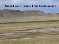
This <strong>in</strong>vestigation is part of an on-go<strong>in</strong>g hydrogeologic study on the Nature Conservancy’s<br />
Cather<strong>in</strong>e Wolter Wilderness Area <strong>in</strong> Vilas County, Wiscons<strong>in</strong>, located with<strong>in</strong> the Pleistocene<br />
drift region. The stratigraphy at this 2,189 acre site is characterized by <strong>in</strong>terweav<strong>in</strong>g of<br />
discont<strong>in</strong>uous strata, lens-shaped sedimentary layers, and paleo-channels deposited dur<strong>in</strong>g<br />
glaciations. The long term goal is to understand the groundwater flow <strong>in</strong> the region. Locat<strong>in</strong>g<br />
hydrostratigraphic boundaries <strong>in</strong> heterogeneous aquifers is often difficult; however, a<br />
comprehensive understand<strong>in</strong>g of the hydrostratigraphy can be improved by utiliz<strong>in</strong>g well<br />
construction reports and electrical resistivity profiles and sound<strong>in</strong>gs.<br />
<strong>Water</strong>-level elevations at 44 wells and surface water elevations were used to construct a<br />
water table map. Us<strong>in</strong>g over 20 electrical sound<strong>in</strong>gs conducted <strong>in</strong> 2003 and six electrical<br />
profiles us<strong>in</strong>g a GF Instruments profil<strong>in</strong>g system (ARES) conducted <strong>in</strong> October 2010, four<br />
stratigraphic sections were constructed. Electrical resistivity data is charted along with<br />
subsurface stratigraphy to produce a multi-layer stratigraphic model with<strong>in</strong> a s<strong>in</strong>gle aquifer to<br />
aid <strong>in</strong> understand<strong>in</strong>g the water movement throughout the region. Historically, two wells have<br />
significantly lower water levels which are expla<strong>in</strong>ed by our model.<br />
* Undergraduate student presentation<br />
** Graduate student presentation<br />
43