Wisconsin's Role in Great Lakes Restoration - American Water ...
Wisconsin's Role in Great Lakes Restoration - American Water ...
Wisconsin's Role in Great Lakes Restoration - American Water ...

You also want an ePaper? Increase the reach of your titles
YUMPU automatically turns print PDFs into web optimized ePapers that Google loves.
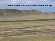
19. How High Will The <strong>Water</strong> Rise? Flood<strong>in</strong>g of the Duck Creek Quarry as an<br />
Un<strong>in</strong>tended Consequence of Deep Aquifer Recovery (Brown County, Wiscons<strong>in</strong>)<br />
John A. Luczaj, Department of Natural and Applied Sciences, University of Wiscons<strong>in</strong> – Green<br />
Bay, Green Bay, WI, luczajj@uwgb.edu<br />
Barb Wavrunek, Time to Dive, Comb<strong>in</strong>ed Locks, WI, bwavrunek@new.rr.com<br />
Bill Roderick, 2519 Lavender Lane, Green Bay, WI, Lowrid5399@yahoo.com<br />
Steven J. Meyer, Department of Natural and Applied Sciences, University of Wiscons<strong>in</strong> –<br />
Green Bay, Green Bay, WI, meyers@uwgb.edu<br />
The Cambro-Ordovician sandstone aquifer <strong>in</strong> the Northeast Groundwater Management Area<br />
(GMA) experienced a dramatic water level recovery <strong>in</strong> central Brown County after 2007.<br />
Between 2006 and 2007, eight communities stopped pump<strong>in</strong>g groundwater for their municipal<br />
supplies and began us<strong>in</strong>g surface water <strong>in</strong>stead, reduc<strong>in</strong>g daily withdrawals from the deep<br />
aquifer by ~12.25 million gallons. The potentiometric surface has <strong>in</strong>creased as much as 150<br />
feet <strong>in</strong> many parts of the GMA. The villages of Howard and Suamico have seen a large part of<br />
the deep aquifer recovery. In places, the potentiometric surface has exceeded ground level<br />
result<strong>in</strong>g <strong>in</strong> multiple flow<strong>in</strong>g artesian wells, <strong>in</strong>clud<strong>in</strong>g the Village of Howard municipal Well #3,<br />
about 7,000 feet north of the Duck Creek Quarry.<br />
The Duck Creek Quarry produced dolostone from the S<strong>in</strong>nipee Group between 1827 and<br />
2001. It is the largest and deepest (170 feet) <strong>in</strong> the area and is known to have <strong>in</strong>tercepted or<br />
nearly <strong>in</strong>tercepted the St. Peter Sandstone at its deepest po<strong>in</strong>t. Before the water supply<br />
switch, the potentiometric surface <strong>in</strong> the aquifer was below the quarry floor. Presently it is<br />
near, or possibly above ground level near the quarry.<br />
We tracked quarry water levels directly dur<strong>in</strong>g 2009-2010 and reconstructed water levels for<br />
2002-2008 us<strong>in</strong>g historical photographs. Data suggest that the rate of <strong>in</strong>crease <strong>in</strong> the quarry’s<br />
water level has accelerated as the deep aquifer recovery has progressed. Climatic variability<br />
<strong>in</strong> precipitation and temperature over the past decade does not appear to be a significant<br />
factor <strong>in</strong> the water level recovery rate, although significant contribution from the shallow<br />
dolostone aquifer is apparent from seeps observed on the quarry walls. If the water level rise<br />
cont<strong>in</strong>ues at its present rate of 4 <strong>in</strong>ches/week, the quarry will flood out some time dur<strong>in</strong>g the<br />
fall of 2011. This could have significant implications for low-ly<strong>in</strong>g properties adjacent to the<br />
quarry and for water quality <strong>in</strong> the Duck Creek.<br />
45