ASTER User's Guide - Aster - NASA
ASTER User's Guide - Aster - NASA
ASTER User's Guide - Aster - NASA

You also want an ePaper? Increase the reach of your titles
YUMPU automatically turns print PDFs into web optimized ePapers that Google loves.
<strong>ASTER</strong> Users Handbook<br />
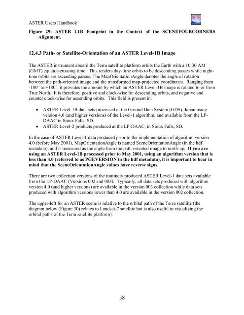
Figure 29: <strong>ASTER</strong> L1B Footprint in the Context of the SCENEFOURCORNERS<br />
Alignment.<br />
12.4.3 Path- or Satellite-Orientation of an <strong>ASTER</strong> Level-1B Image<br />
The <strong>ASTER</strong> instrument aboard the Terra satellite platform orbits the Earth with a 10:30 AM<br />
(GMT) equator-crossing time. This renders day-time orbits to be descending passes while nighttime<br />
orbits are ascending passes. The MapOrientationAngle denotes the angle of rotation<br />
between the path-oriented image and the transformed map-projected coordinates. Ranging from<br />
-180° to +180°, it provides the amount by which an <strong>ASTER</strong> Level-1B image is rotated to or from<br />
True North. It is therefore, positive and clock-wise for descending orbits, and negative and<br />
counter clock-wise for ascending orbits. This field is present in:<br />
• <strong>ASTER</strong> Level-1B data sets processed at the Ground Data System (GDS), Japan using<br />
version 4.0 (and higher versions) of the Level-1 algorithm, and available from the LP-<br />
DAAC in Sioux Falls, SD.<br />
• <strong>ASTER</strong> Level-2 products produced at the LP-DAAC, in Sioux Falls, SD.<br />
In the case of <strong>ASTER</strong> Level-1 data produced prior to the implementation of algorithm version<br />
4.0 (before May 2001), MapOrientationAngle is named SceneOrientationAngle (in the hdf<br />
metadata), and is measured as the angle from the path-oriented image to north-up. If you are<br />
using an <strong>ASTER</strong> Level-1B processed prior to May 2001, using an algorithm version that is<br />
less than 4.0 (referred to as PGEVERSION in the hdf metadata), it is important to bear in<br />
mind that the SceneOrientationAngle values have reverse signs.<br />
There are two collection versions of the routinely produced <strong>ASTER</strong> Level-1 data sets available<br />
from the LP-DAAC (Versions 002 and 003). Typically, all data sets produced with algorithm<br />
version 4.0 (and higher versions) are available in the version 003 collection while data sets<br />
produced with algorithm versions lower than 4.0 are available in the version 002 collection.<br />
The upper-left for an <strong>ASTER</strong> scene is relative to the orbital path of the Terra satellite (the<br />
diagram below (Figure 30) relates to Landsat-7 satellite but is also useful in visualizing the<br />
orbital paths of the Terra satellite platform).<br />
58