ASTER User's Guide - Aster - NASA
ASTER User's Guide - Aster - NASA
ASTER User's Guide - Aster - NASA
You also want an ePaper? Increase the reach of your titles
YUMPU automatically turns print PDFs into web optimized ePapers that Google loves.
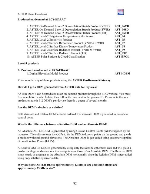
<strong>ASTER</strong> Users Handbook<br />
Produced on-demand at ECS-EDAAC<br />
1. <strong>ASTER</strong> On-Demand Level-2 Decorrelation Stretch Product (VNIR) AST_06VD<br />
2. <strong>ASTER</strong> On-Demand Level-2 Decorrelation Stretch Product (SWIR) AST_06SD<br />
3. <strong>ASTER</strong> On-Demand Level-2 Decorrelation Stretch Product (TIR) AST_06TD<br />
4. <strong>ASTER</strong> Level-2 Brightness Temperature at the Sensor AST_04<br />
5. <strong>ASTER</strong> Level-2 Emissivity Product AST_05<br />
6. <strong>ASTER</strong> Level-2 Surface Reflectance Product (VNIR & SWIR) AST_07<br />
7. <strong>ASTER</strong> Level-2 Surface Kinetic Temperature Product AST_08<br />
8. <strong>ASTER</strong> Level-2 Surface Radiance Product (VNIR & SWIR) AST_09<br />
9. <strong>ASTER</strong> Level-2 Surface Radiance Product (TIR) AST_09T<br />
10. <strong>ASTER</strong> Polar Surface & Cloud Classification AST13POL<br />
Level-3 products<br />
A. Produced on-demand at ECS-EDAAC<br />
1. Digital Elevation Model Product AST14DEM<br />
You can order any of these products using the <strong>ASTER</strong> On-Demand Gateway.<br />
How do I get a DEM generated from <strong>ASTER</strong> data for my area?<br />
<strong>ASTER</strong> DEM’s can be produced as an on-demand product through the EDG website. You must<br />
first search for Level-1A data, then follow the link next to the granule ID. Please note that our<br />
production rate is 1-2 DEM’s per day, so there is a queue of several months.<br />
Are the DEM’s absolute or relative?<br />
Both absolute and relative DEM’s can be ordered. For absolute DEM’s you need to provide a<br />
control point.<br />
What is the difference between a Relative DEM and an Absolute DEM?<br />
An Absolute <strong>ASTER</strong> DEM is generated by using Ground Control Points (GCP) supplied by the<br />
requestor. The software uses the GCPs to tie the DEM to known points on the ground and yields<br />
a product with real ground elevations. The Absolute DEM is geo-coded using customer-supplied<br />
Ground Control Points (GCPs).<br />
A Relative <strong>ASTER</strong> DEM is generated by using only the satellite ephemeris data and will yield a<br />
product with ground elevations that are quite near those of an Absolute DEM. The Relative DEM<br />
is not nearly as accurate as the Absolute DEM horizontally since the Relative DEM is geo-coded<br />
using only satellite ephemeris data.<br />
Why are some <strong>ASTER</strong> DEMs approximately 12 Mb in size and some others are<br />
approximately 25 Mb in size?<br />
82


