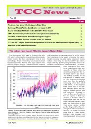
TCC News No. 30
TCC News No. 30
TCC News No. 30

You also want an ePaper? Increase the reach of your titles
YUMPU automatically turns print PDFs into web optimized ePapers that Google loves.
The enhanced anticyclone east of the country featured<br />
an equivalent barotropic structure and a warm air<br />
mass, and its vertical axis exhibited a slight northward<br />
tilt with height (Figure 24). It is presumed that upper-level<br />
PV anomalies induced the enhanced equivalent-barotropic<br />
anticyclone (Hoskins et al. 1985).<br />
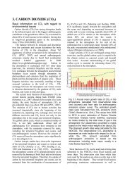
In the upper troposphere, wave trains were seen<br />
along the Asian jet stream in association with the<br />
eastward propagation of Rossby wave packets (Figure<br />
25). Convective activity associated with the Asian<br />
summer monsoon was enhanced over the Arabian<br />
Sea, Pakistan, India and the Bay of Bengal (Figure<br />
26). According to statistical analysis, when convective<br />
activity is enhanced over these areas in and around<br />
South Asia from late August to mid-September, wave<br />
trains with anticyclonic circulation anomalies north of<br />
Japan tend to appear along the Asian jet stream (Figure<br />
27) as seen in 2012 (Figure 25). These trains are<br />
similar to those of the Silk Road pattern highlighted<br />
by T. Enomoto (Enomoto et al. 2003; Enomoto 2004).<br />
It can be presumed from the results of statistical analysis<br />
and research performed to date that active convection<br />
associated with monsoon activity in and<br />
around South Asia contributed to the development of<br />
the enhanced anticyclone near Japan through the<br />
eastward propagation of quasi-stationary Rossby wave<br />
packets along the Asian jet.<br />
Figure 25 200-hPa stream function anomalies (contours),<br />
200-hPa wave activity flux (vectors; unit: m 2 /s 2 ), and outgoing<br />
longwave radiation (OLR) anomalies averaged from<br />
21 August to 20 September, 2012<br />
“A” and “C” indicate the centers of anticyclonic and cyclonic<br />
circulation anomalies, respectively. The contour interval is 3 ×<br />
10 6 m 2 /s. Negative (cold color) and positive (warm color) OLR<br />
anomalies (unit: W/m 2 ) show enhanced and suppressed convection,<br />
respectively. Anomalies are deviations from the 1981 –<br />
2010 average. The wave activity flux is calculated after Takaya<br />
and Nakamura (2001).<br />
Figure 23 Potential vorticity on the 340 K isentropic<br />
surface (contours; unit: s -1 ) and normalized anomalies<br />
(shading) averaged from 21 August to 20 September, 2012<br />
Anomalies (i.e., deviations from the 1981 – 2010 average) are<br />
normalized by their standard deviations.<br />
Figure 24 The vertical-meridional section of stream<br />
function anomalies (contours; unit: 10 6 m 2 /s) and temperature<br />
anomalies (shading; unit: ˚C) averaged from 21<br />
August to 20 September, 2012, along the 150˚E meridian<br />
Anomalies are deviations from the 1981 – 2010 average.<br />
Figure 26 OLR anomalies averaged from 21 August to<br />
20 September, 2012<br />
The green and purple rectangles indicate the area around<br />
South Asia (5˚N – 35˚N, 50˚E – 90˚E) and the area northeast<br />
of the Philippines (10˚N – 25˚N, 120˚E –150˚E), respectively.<br />
Anomalies are deviations from the 1981 – 2010 average.<br />
<strong>TCC</strong> <strong>News</strong> 10 <strong>No</strong>. <strong>30</strong> | Autumn 2012