Equivalent temperature - Climate Science: Roger Pielke Sr.
Equivalent temperature - Climate Science: Roger Pielke Sr.
Equivalent temperature - Climate Science: Roger Pielke Sr.

Create successful ePaper yourself
Turn your PDF publications into a flip-book with our unique Google optimized e-Paper software.
28 C.A. Davey et al. / Global and Planetary Change 54 (2006) 19–32<br />
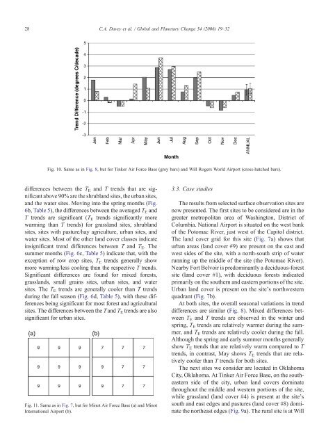
Fig. 10. Same as in Fig. 8, but for Tinker Air Force Base (grey bars) and Will <strong>Roger</strong>s World Airport (cross-hatched bars).<br />
differences between the TE and T trends that are significant<br />
above 90% are the shrubland sites, the urban sites,<br />
and the water sites. Moving into the spring months (Fig.<br />
6b, Table 5), the differences between the averaged TE and<br />
T trends are significant (T E trends significantly more<br />
warming than T trends) for grassland sites, shrubland<br />
sites, sites with pasture/hay agriculture, urban sites, and<br />
water sites. Most of the other land cover classes indicate<br />
insignificant trend differences between T and TE. The<br />
summer months (Fig. 6c, Table 5) indicate that, with the<br />
exception of row crop sites, TE trends generally show<br />
more warming/less cooling than the respective T trends.<br />
Significant differences are found for mixed forests,<br />
grasslands, small grains sites, urban sites, and water<br />
sites. The T E trends are generally cooler than T trends<br />
during the fall season (Fig. 6d, Table 5), with these differences<br />
being significant for most forest and agricultural<br />
sites. The differences between the T and TE trends are also<br />
significant for urban sites.<br />
Fig. 11. Same as in Fig. 7, but for Minot Air Force Base (a) and Minot<br />
International Airport (b).<br />
3.3. Case studies<br />
The results from selected surface observation sites are<br />
now presented. The first sites to be considered are in the<br />
greater metropolitan area of Washington, District of<br />
Columbia. National Airport is situated on the west bank<br />
of the Potomac River, just west of the Capitol district.<br />
The land cover grid for this site (Fig. 7a) shows that<br />
urban areas (land cover #9) are present on the east and<br />
west sides of the site, with a north-south strip of water<br />
running up the middle of the site (the Potomac River).<br />
Nearby Fort Belvoir is predominantly a deciduous-forest<br />
site (land cover #1), with deciduous forests indicated<br />
primarily on the southern and eastern portions of the site.<br />
Urban land cover is present on the site's northwestern<br />
quadrant (Fig. 7b).<br />
At both sites, the overall seasonal variations in trend<br />
differences are similar (Fig. 8). Mixed differences between<br />
TE and T trends are observed in the winter and<br />
spring, TE trends are relatively warmer during the summer,<br />
and T E trends are relatively cooler during the fall.<br />
Although the spring and early summer months generally<br />
show T E trends that are relatively warm compared to T<br />
trends, in contrast, May shows TE trends that are relatively<br />
cooler than T trends for both sites.<br />
The next sites we consider are located in Oklahoma<br />
City, Oklahoma. At Tinker Air Force Base, on the southeastern<br />
side of the city, urban land covers dominate<br />
throughout the middle and western portions of the site,<br />
while grassland (land cover #4) is present at the site's<br />
south and east edges and pastures (land cover #8) dominate<br />
the northeast edges (Fig. 9a). The rural site is at Will