FERC vs NERC: A grid control showdown over cyber security
FERC vs NERC: A grid control showdown over cyber security
FERC vs NERC: A grid control showdown over cyber security

Create successful ePaper yourself
Turn your PDF publications into a flip-book with our unique Google optimized e-Paper software.
4D<br />
WWW.INTELLIGENTUTILITY.COM /// JULY/AUGUST 2011<br />
40<br />
Location is imperative<br />
+ + Geospatial data is central to Hydro One smart <strong>grid</strong><br />
By Nargis Ladha and Erik Shepard<br />
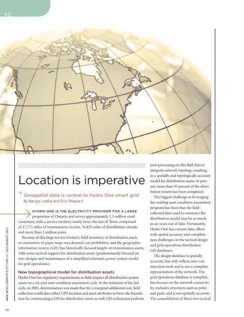
HYDRO ONE IS THE ELECTRICITY PROVIDER FOR A LARGE<br />
proportion of Ontario and serves approximately 1.3 million rural<br />
customers, with a service territory nearly twice the size of Texas, comprised<br />
of 17,771 miles of transmission circuits, 76,429 miles of distribution circuits<br />
and more than 2 million poles.<br />
Because of this large service territory, field inventory of distribution assets<br />
or conversion of paper maps was deemed cost prohibitive, and the geographic<br />
information system (GIS) has historically focused largely on transmission assets,<br />
with some tactical support for distribution assets (predominantly focused on<br />
new designs and maintenance of a simplified schematic power system model<br />
for <strong>grid</strong> operations).<br />
New topographical model for distribution assets<br />
Hydro One has regulatory requirements to field-inspect all distribution system<br />
assets on a six-year asset condition assessment cycle. At the initiation of the last<br />
cycle, in 2005, determination was made that for a marginal additional cost, field<br />
collection could also collect GPS location and asset attributes to form the foundation<br />
for constructing a GIS for distribution assets as well. GIS technicians perform<br />
post-processing on this field data to<br />
integrate network topology, resulting<br />
in a spatially and topologically accurate<br />
model for distribution assets. At present,<br />
more than 95 percent of the distribution<br />
system has been completed.<br />
The biggest challenge to leveraging<br />
the existing asset condition assessment<br />
program has been that the fieldcollected<br />
data used to construct the<br />
distribution model may be as much<br />
as six years out of date. Fortunately,<br />
Hydro One has current data, albeit<br />
with spatial accuracy and completeness<br />
challenges, in the tactical design<br />
and <strong>grid</strong> operations distribution<br />
GIS databases.<br />
The design database is spatially<br />
accurate, but only reflects new construction<br />
work and is not a complete<br />
representation of the network. The<br />
<strong>grid</strong> operations database is complete,<br />
but focuses on the network connectivity,<br />
excludes structures such as poles<br />
and pads, and is not spatially accurate.<br />
The consolidation of these two tactical


![View From the Trenches [PDF]](https://img.yumpu.com/18854438/1/190x252/view-from-the-trenches-pdf.jpg?quality=85)