Issue 4 May 2010 - LTA Academy
Issue 4 May 2010 - LTA Academy
Issue 4 May 2010 - LTA Academy

You also want an ePaper? Increase the reach of your titles
YUMPU automatically turns print PDFs into web optimized ePapers that Google loves.
surface deterioration, road carriageways are<br />
maintained at an optimum level of roughness<br />
and skid resistance to prevent possible skidding<br />
during wet weather.<br />
At construction sites, GIS is used to enhance<br />
the safety of construction workers and the<br />
community in the environs. Specialised<br />
sensing instruments are enabled with GIS<br />
technology to monitor construction activities<br />
that may affect the integrity of structures and<br />
buildings in the vicinity. The United Kingdombased<br />
Royal Society for the Prevention of<br />
Accidents (RoSPA) has named <strong>LTA</strong> in its annual<br />
honour roll of organisations committed to<br />
occupational safety and health in 2008 for<br />
achieving a high level of safety performance<br />
underpinned by good management systems.<br />
Being pro-enterprise<br />
Business communities and industry partners<br />
also enjoy greater convenience and a more<br />
seamless experience when transacting with<br />
<strong>LTA</strong>. Leading an online inter-agency system<br />
that leverages on GIS to coordinate road<br />
construction works, <strong>LTA</strong> has reduced the<br />
processing time for approval of road works<br />
applications from 2 – 3 months to within 2<br />
weeks. The duration for approval of plans<br />
for civil and structural works is also reduced<br />
by 50%. Surveyors, real estate developers,<br />
lawyers, architects, and engineers can also<br />
obtain online road line plans instantaneously,<br />
whereas previously they had to wait up to<br />
10 days.<br />
Strategic information dissemination<br />
<strong>LTA</strong> shares data from our GIS@<strong>LTA</strong> initiative<br />
with various agencies in the government<br />
GIS@<strong>LTA</strong> – Bringing Maps to Life<br />
sector. Our data is used by the government<br />
agencies in areas such as strategic planning,<br />
operations management, research studies,<br />
homeland security, crime prevention and<br />
risk management. <strong>LTA</strong> also supports the<br />
development of the National Spatial Data<br />
Infrastructure (SDI). This is the national strategy<br />
for information sharing.<br />
Strategic partnerships are formed with the<br />
likes of Google, Nokia and local start-ups,<br />
such as, Quantum Inventions, a company that<br />
processes <strong>LTA</strong>’s raw traffic data to provide<br />
real-time traffic information, dynamic routing<br />
and navigation solutions, to further exploit<br />
its enterprise geospatial data to benefit end<br />
users. These collaborations have brought<br />
about an array of innovative services that<br />
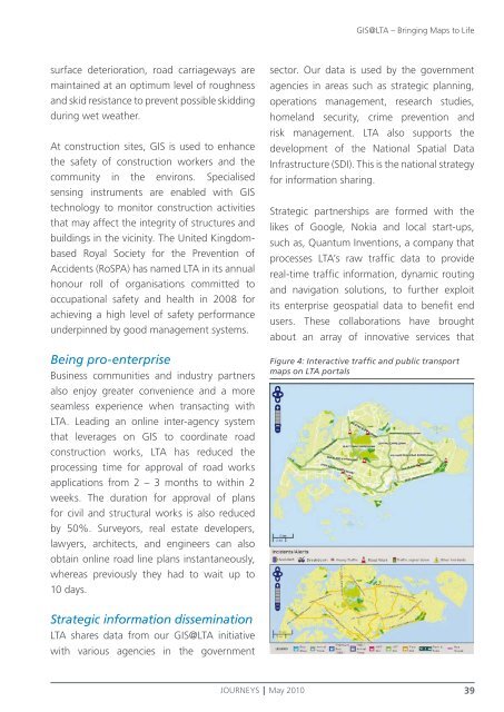
Figure 4: Interactive traffic and public transport<br />
maps on <strong>LTA</strong> portals<br />
JOURNEYS <strong>May</strong> <strong>2010</strong> 39