

Download - Coordinates
Download - Coordinates
Download - Coordinates

Create successful ePaper yourself
Turn your PDF publications into a flip-book with our unique Google optimized e-Paper software.
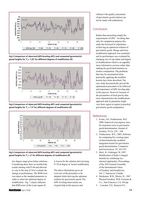
Fig.3 Comparison of observed (GPS-leveling diff.) and computed (gravimetric)<br />
geoid heights for Ψ 0 = 1.25 0 for different degrees of modification (P)<br />
Fig.4 Comparison of observed (GPS-leveling diff.) and computed (gravimetric)<br />
geoid heights for Ψ 0 = 1.5 0 for different degrees of modification (P)<br />
Fig.5 Comparison of observed (GPS-leveling diff.) and computed (gravimetric)<br />
geoid heights for Ψ 0 = 2 0 for different degrees of modification (P)<br />
low degree range gives better solutions.<br />
Considering these facts we testified the<br />
results starting with P=40 and allowed<br />
to vary in the step of 10 to evaluate the<br />
change in performance. The RMS error<br />
was taken as the standard parameter in<br />
order to select the optimum degree of<br />
modification. Fig. 7 clearly indicates<br />
that RMS error of the Least square fit<br />
is lowest for the solution derived using<br />
P=70 as degree of kernel modification.<br />
The above illustrations gives an<br />
overview of the procedure to be<br />
adopted while deriving the optimum<br />
solution for gravimetric geoid. The<br />
GPS–leveling observations are<br />
of great help in this process and<br />
without it the quality assessment<br />
of gravimetric geoid solution can<br />
not be made with authenticity.<br />
Conclusion<br />
Rather than presenting simply the<br />
requirements of GPS – levelling data<br />
only for comparison purpose this<br />
study has focussed its importance<br />
in deriving an optimized solution of<br />
gravimetric geoid. Wonge and Gore<br />
modification approach was examined<br />
and its performance was evaluated by<br />
changing size of cap radius and degree<br />
of modifications which is an arguably<br />
more informative exercise rather than<br />
making the geoid determination as<br />
routine computation. The problems<br />
that may be encountered when<br />
practically applying the modified<br />
kernels have been described. The<br />
case study has practically proved the<br />
optimisation procedure to be followed<br />
and importance of GPS–leveling data<br />
in this process. However, because of<br />
the pecularities of local gravity data<br />
error characteristics the modifications<br />
approach and its parameter might<br />
vary from region to region in practical<br />
gravimetric geoid computation<br />
References<br />
1. Evans, J.D., Featherstone, W.E.<br />
2000. Improved convergence rates<br />
for truncation error in gravimetric<br />
geoid determination, Journal of<br />
Geodesy 74 (2), 239 – 248.<br />
2. Featherstone. W.E., 2003, Software<br />
for computing five existing types<br />
of deterministically modified<br />
integration kernel for gravimetric<br />
geoid determination. Computers<br />
and Geosciences, 29, 183-193.<br />
3. Heck. B., Grüninger, W.,1987.<br />
Modification of Stoke’s integral<br />
formula by combining two<br />
classical approaches. Proceedings<br />
of the XIX General Assembly<br />
of the International Union<br />
of Geodesy and Geophysics,<br />
Vol. 2. Vancouver, Canada.<br />
4. Heiskanen, W.H., Moritz, H., 1967.<br />
Physical Geodesy. W.H. Freeman &<br />
Co.., San Francisco, CA, 364 pp.<br />
5. Lemoine, F.G., Kenyon S.C.,<br />
April 2006 11


