Kuwait : Complete Profile - What is GIS - World Health Organization
Kuwait : Complete Profile - What is GIS - World Health Organization
Kuwait : Complete Profile - What is GIS - World Health Organization

Create successful ePaper yourself
Turn your PDF publications into a flip-book with our unique Google optimized e-Paper software.
<strong>Health</strong> Systems <strong>Profile</strong>- <strong>Kuwait</strong> Regional <strong>Health</strong> Systems Observatory- EMRO<br />
2.3 Geography and Climate<br />
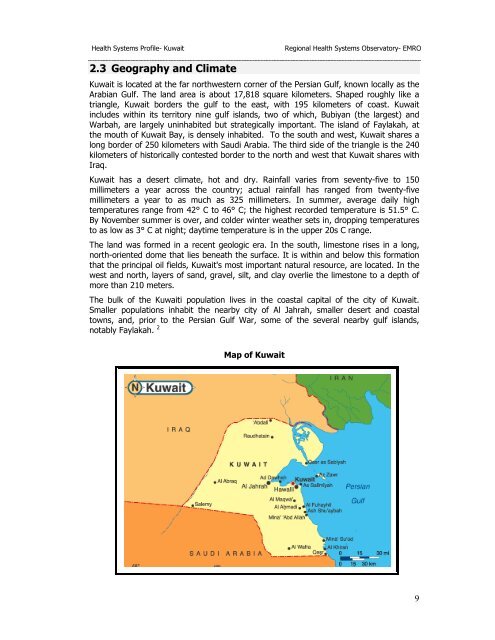
<strong>Kuwait</strong> <strong>is</strong> located at the far northwestern corner of the Persian Gulf, known locally as the<br />
Arabian Gulf. The land area <strong>is</strong> about 17,818 square kilometers. Shaped roughly like a<br />
triangle, <strong>Kuwait</strong> borders the gulf to the east, with 195 kilometers of coast. <strong>Kuwait</strong><br />
includes within its territory nine gulf <strong>is</strong>lands, two of which, Bubiyan (the largest) and<br />
Warbah, are largely uninhabited but strategically important. The <strong>is</strong>land of Faylakah, at<br />
the mouth of <strong>Kuwait</strong> Bay, <strong>is</strong> densely inhabited. To the south and west, <strong>Kuwait</strong> shares a<br />
long border of 250 kilometers with Saudi Arabia. The third side of the triangle <strong>is</strong> the 240<br />
kilometers of h<strong>is</strong>torically contested border to the north and west that <strong>Kuwait</strong> shares with<br />
Iraq.<br />
<strong>Kuwait</strong> has a desert climate, hot and dry. Rainfall varies from seventy-five to 150<br />
millimeters a year across the country; actual rainfall has ranged from twenty-five<br />
millimeters a year to as much as 325 millimeters. In summer, average daily high<br />
temperatures range from 42° C to 46° C; the highest recorded temperature <strong>is</strong> 51.5° C.<br />
By November summer <strong>is</strong> over, and colder winter weather sets in, dropping temperatures<br />
to as low as 3° C at night; daytime temperature <strong>is</strong> in the upper 20s C range.<br />
The land was formed in a recent geologic era. In the south, limestone r<strong>is</strong>es in a long,<br />
north-oriented dome that lies beneath the surface. It <strong>is</strong> within and below th<strong>is</strong> formation<br />
that the principal oil fields, <strong>Kuwait</strong>'s most important natural resource, are located. In the<br />
west and north, layers of sand, gravel, silt, and clay overlie the limestone to a depth of<br />
more than 210 meters.<br />
The bulk of the <strong>Kuwait</strong>i population lives in the coastal capital of the city of <strong>Kuwait</strong>.<br />
Smaller populations inhabit the nearby city of Al Jahrah, smaller desert and coastal<br />
towns, and, prior to the Persian Gulf War, some of the several nearby gulf <strong>is</strong>lands,<br />
notably Faylakah. 2<br />
Map of <strong>Kuwait</strong><br />
9