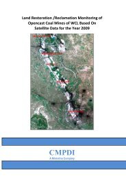
pench-kanhan coalfields - Western Coalfields Ltd. India.
pench-kanhan coalfields - Western Coalfields Ltd. India.
pench-kanhan coalfields - Western Coalfields Ltd. India.

Create successful ePaper yourself
Turn your PDF publications into a flip-book with our unique Google optimized e-Paper software.
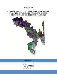
Job No. 561410027 (WCL) 11<br />
CMPDI<br />
(a) Spectral coverage/resolution, i.e., band locations/width; (b) spectral<br />
dimensionality: number of bands; (c) radiometric resolution:<br />
quantisation; (d) spatial resolution/instantaneous field of view or<br />
IFOV; and (e) temporal resolution. Table 2.2 illustrates the basic<br />
properties of Resourcesat satellite/sensor that was used in the<br />
present study.<br />
Table 2.2 Characteristics of the satellite/sensor used in the present project work<br />
Platform Sensor Spectral Bands in µm Radiometric<br />
Resolution<br />
Rsource<br />
sat<br />
(P6)<br />
LISS-III B<br />
2<br />
B<br />
3<br />
B<br />
4<br />
B<br />
5<br />
0.28<br />
0.25<br />
0.27<br />
6.90<br />
-<br />
-<br />
-<br />
0.3<br />
1<br />
0.3<br />
8<br />
0.3<br />
0<br />
NIR: Near Infra-Red MIR: Middle Infra-Red<br />
2.6 Data Processing<br />
Green<br />
Red<br />
NIR<br />
MIR<br />
7-bit<br />
(128-grey levels)<br />
Spatial<br />
Resolution Temporal<br />
Resolution Country<br />
23.5 m<br />
23.5 m<br />
23.5 m<br />
70.5 m<br />
24 days <strong>India</strong><br />
The details of data processing carried out in the present study are shown in<br />
Figure 2.4. The processing methodology involves the following major steps:<br />
(a) Geometric correction, rectification and geo-referencing;<br />
(b) Image enhancement;<br />
(c) Training set selection;<br />
(d) Signature generation and classification;<br />
(e) Creation/overlay of vector database;<br />
(f) Validation of classified image;<br />
(g) Final thematic map preparation.