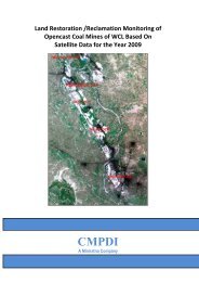
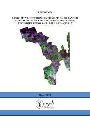
pench-kanhan coalfields - Western Coalfields Ltd. India.
pench-kanhan coalfields - Western Coalfields Ltd. India.
pench-kanhan coalfields - Western Coalfields Ltd. India.

You also want an ePaper? Increase the reach of your titles
YUMPU automatically turns print PDFs into web optimized ePapers that Google loves.
2.6.1 Geometric correction, rectification and geo-referencing<br />
Job No. 561410027 (WCL) 13<br />
CMPDI<br />
Inaccuracies in digital imagery may occur due to ‘systematic errors’<br />
attributed to earth curvature and rotation as well as ‘non-systematic errors’<br />
attributed to intermittent sensor malfunctions, etc. Systematic errors are<br />
corrected at the satellite receiving station itself while non-systematic errors/<br />
random errors are corrected in pre-processing stage.<br />
In spite of ‘System / Bulk correction’ carried out at supplier end; some<br />
residual errors in respect of attitude attributes still remains even after<br />
correction. Therefore, fine tuning is required for correcting the image<br />
geometrically using ground control points (GCP).<br />
Raw digital images contain geometric distortions, which make them<br />
unusable as maps. A map is defined as a flat representation of part of the<br />
earth’s spheroidal surface that should conform to an internationally accepted<br />
type of cartographic projection, so that any measurements made on the map<br />
will be accurate with those made on the ground. Any map has two basic<br />
characteristics: (a) scale and (b) projection. While scale is the ratio between<br />
reduced depiction of geographical features on a map and the geographical<br />
features in the real world, projection is the method of transforming map<br />
information from a sphere (round Earth) to a flat (map) sheet. Therefore, it is<br />
essential to transform the digital image data from a generic co-ordinate<br />
system (i.e. from line and pixel co-ordinates) to a projected co-ordinate<br />
system. In the present study georeferencing was done with the help of<br />
Survey of <strong>India</strong> (SoI) topo-sheets so that information from various sources<br />
can be compared and integrated on a GIS platform, if required.<br />
An understanding of the basics of projection system is required before<br />
selecting any trans/formation model. While maps are flat surfaces, Earth<br />
however is an irregular sphere, slightly flattened at the poles and bulging at