FY2009 - Former Fort Ord - Environmental Cleanup
FY2009 - Former Fort Ord - Environmental Cleanup
FY2009 - Former Fort Ord - Environmental Cleanup

Create successful ePaper yourself
Turn your PDF publications into a flip-book with our unique Google optimized e-Paper software.
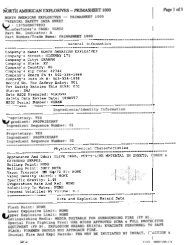
STATUS<br />
Parcel: DEL REY OAKS (FORA) (FOST 10) (4.66 acres),BLM<br />
(7444 acres),MONTEREY COUNTY (FORA) (FOSET 5)<br />
(2290 acres),SEASIDE (FORA) (FOSET 5) (615.43<br />
acres)<br />
Regulatory Driver: CERCLA<br />
RRSE: HIGH<br />
Program: BRAC-IRP<br />
Contaminants of Concern: Explosives, Metals, Semivolatiles<br />
(SVOC)<br />
Media of Concern: Soil<br />
BRAC Round: BRAC II<br />
SITE DESCRIPTION<br />
CLEANUP/EXIT STRATEGY<br />
Site ID: FTO-039<br />
Site Name: SITE 39 INLAND RANGES<br />
Phases Start End<br />
PA................... 199006........ 199012<br />
SI..................... 199006........ 199012<br />
RI/FS............... 199006........ 199510<br />
RD................... 199603........ 199801<br />
RA(C).............. 200809........ 201609<br />
LTM................. 201610........ 202309<br />
N/A<br />
RC Date: 201609<br />
FTO-039 Site 39 is in the southwestern portion of the former <strong>Fort</strong> <strong>Ord</strong> and includes the impact area (approximately 8,000 acres)<br />
and the 2.36-inch rocket range (approximately 50 acres). The impact area is bounded by Eucalyptus Road to the north, Barloy<br />
Canyon Road to the east, South Boundary Road to the south, and General Jim Moore Blvd to the west. The 2.36-inch rocket range<br />
is immediately north of Eucalyptus Road, near the north-central portion of the impact area.<br />
The impact area was reportedly used since the early 1900s for ordnance training exercises. Over the years, various types of<br />
ordnance have been used or found in the impact area, including hand grenades, mortars, rockets, mines, artillery rounds, and small<br />
arms rounds. Some training activities using petroleum hydrocarbons were also conducted. The 2.36-inch rocket range was<br />
reportedly used for anti-armor (bazooka) training during and shortly after World War II.<br />
The proposed future use of most of the impact area will be a natural resource management area (NRMA). This area will be<br />
managed by the US Department of the Interior, Bureau of Land Management (BLM), and public access will be managed or<br />
restricted. Several areas within, but along the periphery of, the impact area have a proposed future land use other than as a NRMA.<br />
The Military Operations on Urbanized Terrain (MOUT) Area, in the northeastern edge of the impact area, are proposed for use as a<br />
law enforcement training area. The areas along the south and west boundary of the impact area are proposed for several uses,<br />
including commercial and residential development, a school expansion, and relocation of Highway 68. Identified soil contamination<br />
in the areas along the south and west boundary of the impact area has been addressed to support the identified reuse(s) in those<br />
areas. In many cases the agencies have concurred that cleanup goals have been met and the property, in some cases, has been<br />
transferred.<br />
The selected RAs for Site 39 in the base wide ROD (Army, 1997) were excavation of soils with concentrations above 1,860 parts<br />
per million lead (the identified level to address human health) and placement of soils in the <strong>Fort</strong> <strong>Ord</strong> Landfill in accordance with the<br />
substantive requirements of the Corrective Action Management Unit (CAMU) regulations. The cleanup levels to address ecological<br />
risks were not identified in the 1997 ROD. Additional investigations have occurred since the 1997 ROD to fully characterize the<br />
area. An ecological risk assessment and FS addendum to identify remedial cleanup levels was completed in 2007, with a ROD<br />
amendment to the 1997 ROD being staffed for signature. The FS addendum identified the specific areas and volumes of<br />
contaminated soils to be excavated and removed. The current estimate is 125,000 cubic yards. The ROD amendment also includes<br />
a process to address additional areas of contamination that may be identified in the future during munitions and explosives of<br />
concern remediation. The ROD amendment was required to establish cleanup levels to address ecological risks and due to the<br />
significant increases in soils volumes to be excavated and placed at the former <strong>Fort</strong> <strong>Ord</strong> landfill.<br />
There is no impact to the GW at Site 39.<br />
RIP Date:<br />
Final FORT ORD Installation Action Plan - 15