FY2009 - Former Fort Ord - Environmental Cleanup
FY2009 - Former Fort Ord - Environmental Cleanup
FY2009 - Former Fort Ord - Environmental Cleanup

Create successful ePaper yourself
Turn your PDF publications into a flip-book with our unique Google optimized e-Paper software.
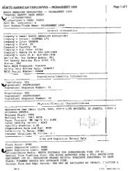
STATUS<br />
Parcel: MONTEREY COUNTY (FORA) (FOST 10) (380.05<br />
acres),BLM (7444 acres)<br />
Regulatory Driver: CERCLA<br />
Program: BRAC-MMRP<br />
MRSPP Score:<br />
03<br />
Contaminants of Concern: Munitions and explosives of<br />
concern (MEC)<br />
Media of Concern: Soil<br />
BRAC Round: BRAC II<br />
SITE DESCRIPTION<br />
CLEANUP/EXIT STRATEGY<br />
Site ID: FTO-002-R-01<br />
Site Name: BLM-EAST OTHER<br />
Phases Start End<br />
PA................... 200111........ 200306<br />
RI/FS............... 200710........ 201709<br />
RA(C).............. 201710........ 201909<br />
LTM................. 201910........ 203909<br />
The site strategy for this range complex includes RI followed by a Track 1 plug-in decision document for a majority of this FTO<br />
that is expected to require no further action. Based on the Preliminary Draft Remaining RI/FS Areas Management Plan, 553 acres<br />
of this range complex will be evaluated in a Track 2-type RI/FS and ROD. The Track 2 area would require MEC removal. The<br />
addition of a Track 2 component is a change in site strategy that results in a significant increase in the Cost-to-Complete<br />
estimate. This range complex would require LTM.<br />
An explanation of the remedial activities for Tracks 0-3 can be found in the <strong>Cleanup</strong> Program Summary section.<br />
N/A<br />
RC Date: 201909<br />
The BLM East Other range complex (FTO-002-R-01) contains approximately 4,929.8 acres that surround the BLM East complex<br />
areas on the southeast portion of former <strong>Fort</strong> <strong>Ord</strong>. The acreage of this complex is not specifically identified as a range; however,<br />
these areas were used by troops to get from one area to another within BLM East and, as such, are defined as range areas. The<br />
acreage of the complex was included in 1984 training facilities maps of small unit maneuver areas. The area is not indicated or<br />
identified as an area where military munitions were used. The complex has been transferred to the BLM for use as public lands.<br />
The area is subject to the requirements of an MR RI/FS. This area is assumed to have been used during the same period as BLM<br />
East range complex.<br />
An explanation of the remedial activities for MR RI/FS Tracks 0-3 can be found in the <strong>Cleanup</strong> Program Summary section of this<br />
BIAP.<br />
Investigation of potential soil contamination is conducted under a separate RI/FS program. This range complex is within areas<br />
designated as Natural Resource Management Area. Prescribed burning is the preferred method of vegetation clearance in support<br />
of any RA in habitat areas.<br />
The site strategy for this range complex includes the following actions:<br />
RIP Date:<br />
- A remedial investigation followed by a Track 1 plug-in decision document will be required for a majority of this FTO. The results<br />
of the Track 1 plug-in decision document are expected to require NFA.<br />
- Based on the Preliminary Draft Remaining RI/FS Areas Management Plan, 553 acres of this range complex will be evaluated in a<br />
Track 2-type RI/FS and ROD. The Track 2 area would require MEC removal.<br />
-This range complex would require LTM.<br />
Final FORT ORD Installation Action Plan - 31