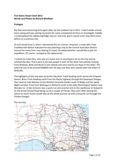
Five States Desert D..
Five States Desert D..
Five States Desert D..

Create successful ePaper yourself
Turn your PDF publications into a flip-book with our unique Google optimized e-Paper software.
<strong>Five</strong> <strong>States</strong> <strong>Desert</strong> Dash 2013<br />
Words and Photos by Richard Windeyer<br />
Prologue<br />
My feet were becoming itchy again after my last outback trip in 2011. I had 4 weeks annual<br />
leave owing and was racking my brains for some unexplored territory to investigate. Initially<br />
I contemplated the Lightening Ridge area as I had only spent a quick lunch stop there once<br />
before on a previous trip.<br />
As luck would have it, when I mentioned this on a forum I frequent, a mate who I had<br />
travelled with before indicated he was planning a trip to the Central Australian deserts<br />
around the same time I was looking to travel. He asked whether I would like to join his<br />
expedition. Of course, I jumped at the opportunity.<br />
I invited my mate Ross, who was at a loose end, to accompany me on the trip and he<br />
relished the idea. There were to be two people in each of the other two vehicles coming<br />
from Brisbane, Brett and Norm in one vehicle and Leon and his son Ryan in the other. The<br />
total trip was to be around 9500KM over 24 days and Ross and I would meet the others in<br />
Birdsville.<br />
The highlights of this trip were to be the Hay River Track heading north across the Simpson<br />
<strong>Desert</strong>, Binns Track heading north from the Plenty Highway through the Davenport Ranges,<br />
then west to Lake Mackay on the Western Australia border south of Balgo and the Sandy<br />
Blight Junction Track from Walungurru (Kintore) south to the Giles Metrological Station near<br />
Warakurna . A late inclusion was a quick run and surprise visit to the roadhouse at Tjukayirla<br />
on the Great Central Road being run by a couple of friends. Ross and I after leaving the<br />
others to return home would tidy up the whole journey up with a leisurely run through the<br />
Flinders Ranges.<br />
The Journey:<br />
Page 1 of 23
The vehicle was prepared for the journey over the previous two weekends prior to the start<br />
of the trip with all the necessities and spares required for this remote trek. The idea of<br />
having a qualified mechanic in one of the other two vehicles was a bonus.<br />
Prior to the trip we applied for and obtained the appropriate indigenous permits required<br />
for all the areas in which we would be travelling. This required fair amount of work from<br />
both Leon and Brett, mainly trying to contact people, and Ross and I reaped the benefits.<br />
I was to finish work on a Friday and Ross and myself were to be away early the next day.<br />
Sat 22 June – Sydney to Bourke<br />
Leaving Sydney on a glorious sunny but chilly Saturday morning we headed west over the<br />
Blue Mountains through Katoomba. It was a good run with not much traffic about, although<br />
the continuing roadwork's slowed us down through some sections. Once on the highway we<br />
stuck to the blacktop travelling through Lithgow, Bathurst, Dubbo and Nyngan where we<br />
stopped for lunch. Not many shops were open in Nyngan when we arrived early afternoon<br />
however we managed to grab a feed at the only open cafe.<br />
Leaving Nyngan I was sitting on what I thought was the speed limit on the Mitchell Highway<br />
of 110 kph when a highway patrol vehicle passed me going in the opposite direction and I<br />
thought nothing of it. Not long after I glanced in my rear view mirror to see the same<br />
highway patrol car tailing me so I slowed down to 80kph. When he put on the flashing lights<br />
I thought - oh, oh and pulled over. A burly police officer, accompanied by his partner, stuck<br />
his head in my window and said G'day. Imagine my surprise when it turned out to be a mate<br />
who was patrolling the area and he confirmed that the speed limit was in fact 110kph. He<br />
knew I would be in the area at the time and had kept a lookout. We had a quick chat and<br />
were soon on our way again.<br />
Late afternoon we arrived in Bourke and refuelled. I had planned to camp ant Eight Mile<br />
Lagoon which is a billabong on the Darling River near the Bourke Stockade that I had visited<br />
before but never camped. The spot I had decided on, having visited it on a previous trip, was<br />
inaccessible due to level of the water. Scouting around I found a lovely spot on higher<br />
ground which jutted out into the lagoon so we were surrounded by water on three sides.<br />
As it was on dusk we quickly set up<br />
camp and gathered some firewood<br />
which was fairly scarce in the area. I<br />
set up my swag under the car awning<br />
and Ross put up his popup tent. Ross<br />
prepared dinner and we relaxed<br />
around the fire and watched as the<br />
moon which was almost full rose<br />
over the water. We shivered as the<br />
temperature dropped dramatically<br />
on this crystal clear and starry night.<br />
Page 2 of 23
Sun 23 Jun – Bourke to Quilpie<br />
Working as a postie I'm normally up 5am and it's hard to change the body clock overnight so<br />
I was awake before sunrise to a very cold morning and coaxed the fire into life. What better<br />
way to spend quality time at this ungodly hour than to take some photos of the moonset<br />
over the lagoon. It was some time later and after sunrise that Ross was up and we made<br />
breakfast before packing up camp. On our way back to the main road we stopped for a look<br />
at the Bourke Stockade and then headed back to Bourke.<br />
leaving Bourke we travelled on the Mitchell Highway following the Warrego River heading<br />
for Enngonia crossing the Queensland border at Barringun and then travelling on to<br />
Cunnamulla. Heading west on the Bulloo Developmental Road we passed through Eulo and<br />
then headed to Quilpie which was our destination for the night. We contacted the other<br />
guys coming from Brisbane and found we were 250km behind them and they were setting<br />
up camp at Windorah. As it was late we decided not to push on to catch them.<br />
The book Camps 4 had indicated a free campsite at Lake Houdraman about 5km northwest<br />
of Quilpie. When we finally worked which direction it was out of town and arrived late<br />
afternoon we found numerous campers already in residence. We squeezed into a lovely<br />
spot on the water's edge and set up camp. There was abundant birdlife on the lake and we<br />
watched as the full moon rose over the lake reflecting in the water against the reverse<br />
sunset. A pelican cruised past creating a rippled wake behind distorting the moons<br />
reflection. As firewood was scarce in the area we had to make do with an imaginary fire,<br />
however it was starting to warm up so it was not much of an issue.<br />
Wed 24 Jun – Quilpie to Birdsville<br />
I was again up early and watched the magnificent sunrise as it reflected in the lake. After<br />
packing up camp we were on our way again early heading north west for Windorah crossing<br />
Coopers Creek before we entered town.<br />
Continuing west we stopped for lunch on the side of the road beside a dry creek bed and<br />
Ross made some rollups filled with cheese and tomato. After lunch we came across another<br />
vehicle stopped on the side of the road and noticed they were watching a Black Headed<br />
Python on the road. We returned to the spot for a closer look. Bypassing Betoota on a new<br />
section of road we arrived in Birdsville late afternoon.<br />
Page 3 of 23
In Birdsville I refuelled and filled three empty jerries with 70L of Diesel for the Hay River leg<br />
of our trip. We again contacted the other group from Brisbane and found they had also just<br />
arrived in Birdsville having detoured to Haddon's Corner which is the corner of the South<br />
Australian border jutting into Queensland.<br />
We located the others and set up camp<br />
next to them in the Birdsville Caravan<br />
Park on the bore drain lake draining into<br />
the Diamantina River. The river was up<br />
so I tossed two opera house yabby traps<br />
into the water using raw potato as bait.<br />
Yabbies are vegetarian by nature and the<br />
myth that they eat meat is only because<br />
they like to clear their territory of rotting<br />
matter.<br />
The Queensland guys showed us the two<br />
ammo tins they had bought with them. The gray Overlander ammo tin which had started its<br />
journey in 2004 and been around Australia a few times gathering artefacts and journal<br />
entries on its way and a new pink Underlander ammo tin on its inaugural journey.<br />
After having a lovely hot shower we headed to the famous Birdsville pub for refreshments<br />
followed by dinner. The restaurant was crowded so we ordered our food and adjourned to<br />
the bar where we grabbed a vacant table. The food was better quality pub grub with most<br />
of us opting for the hamburger and chips. After a few beverages and a chat about our<br />
different routes to date and planning for the following day's journey we headed back to<br />
camp.<br />
Mon 25 Jun – Birdsville to Hay River Track<br />
Surprise, surprise I was up early again and pulled in the yabby taps. My catch was a tiny<br />
silver perch which I threw back into the water to either be eaten by a bigger fish or grow up<br />
to be caught another time.<br />
After packing up and breaking camp we headed for the Birdsville Bakery where I familiarised<br />
myself again with a curried camel pie. The others had an assorted range of goodies as from<br />
here on for a considerable period it would be camp food.<br />
I was nominated as the days trip leader<br />
having the necessary digital maps on my<br />
laptop running Oziexplorer as well as<br />
having a sand flag. Leaving Birdsville after<br />
the others had filled their jerries we<br />
headed for Little Red and listened on<br />
UHF Chanel 10 as other groups tackled<br />
Big Red with varying success. As we had<br />
Page 4 of 23
all conquered this challenge on past trips we opted to give it a miss. We were lucky there<br />
had not been any significant rain and drove across Eyre Creek without any dramas as when<br />
the creek is running there is a 70km bypass that is necessary.<br />
We travelled the QAA Line to the Northern Territory border and shortly after turned north<br />
north west running parallel to the sand dunes and heading for the shot line. It was at this<br />
time I realised I had been travelling without the centre diff lock on, having knocked the<br />
switch with my knee. No wonder I was struggling up some of the faces of the sand dunes.<br />
It was getting late so we started looking<br />
for a clay pan off the track for a camp site<br />
and as non were obliging we pulled off the<br />
track into a likely reasonably flat area and<br />
set up camp. It didn't take long for a small<br />
fire to be started and we relaxed for the<br />
evening. Nothing like being surrounded by<br />
a sea of red sand glowing in the dying rays<br />
of the sun.<br />
Wed 26 Jun – Hay River Track<br />
With a new leader for the day we headed for the<br />
shot line and took a small detour to have a look at<br />
the site. Onwards we travelled east north east along<br />
the shot line having to traverse the dunes head on<br />
before heading north north west again and then<br />
again running parallel to the sand dunes. We picked<br />
up a trace of the Hay River consisting of a few small<br />
channels between two dunes as we continued on.<br />
We passed Eagles Nest unsure as to why it got its<br />
name as there was nothing obvious that we could<br />
see.<br />
We stopped off at Madigan's camp 16 where<br />
Madigan had blazed a tree. Norm also showed us<br />
another smaller tree he had blazed on four previous<br />
trips over the years although with today's<br />
conservation practises he didn't add another blaze<br />
on this trip.<br />
During the day's journey my radio had started playing up and it wasn't transmitting properly<br />
so I had to resort to transmitting on the handheld and receiving on the in car radio. The dual<br />
battery was also not charging properly resulting a the fridge short cycling and not<br />
performing well when the vehicles motor was turned off.<br />
Page 5 of 23
Our luck for a decent camp site had deserted us and with fading light and Ryan punching<br />
Leon's upper arm for each minute after 4pm, that we were still on the road, we found a<br />
small clearing just off the track.<br />
We set up camp and had dinner around a small camp fire and settled down with<br />
refreshments to listen to the 2nd State of Origin match which we received loud and clear on<br />
my transistor radio. This was a repeat of a previous trip that Ross and I had with Brett to<br />
Cape York that the Cane Toads beat the Cockroaches.<br />
Thur 27 Jun - Hay River Track to Batton Hill<br />
As usual I was up before dawn and prowled around before the others arose and we hit the<br />
track after breakfast.<br />
The river was becoming much more obvious with the classic wide sandy bed and river gums<br />
perched on the banks creating much more scenic terrain. At one point the track entered the<br />
river bed and we followed it for some way after airing down our tyres. We went in search of<br />
the track to Lake Caroline however after much fruitless searching for signs of wheel tracks<br />
we gave up.<br />
We stopped at the Dingo Well and then at the Tropic of Capricorn marker now relishing the<br />
tropical climate. As I negotiated the track under a low tree branch my UHF aerial snapped<br />
at the base. Luckily the wiring was intact and I borrowed two plastic sand pegs from Brett<br />
and was able to splint the aerial with some gaffer tape.<br />
Arriving at Batton Hill Camp,<br />
Lindsay Bookie the owner was<br />
there to greet us and<br />
explained where we would be<br />
camping. The area is split into<br />
different camping areas with<br />
their own fire pit surrounding<br />
a central amenities block. We<br />
set up camp and then had a<br />
well earned hot shower<br />
heated by a donkey boiler<br />
which Lindsay had started<br />
earlier on in the afternoon.<br />
Around sundown a huge flock of Corellas flew in to drink at the waterhole. The raucous<br />
screeching cacophony made it difficult to hear yourself speak however the birds eventually<br />
left to roost elsewhere and a tranquil peace returned. We spent the evening around the<br />
camp fire celebrating Leon's birthday.<br />
Page 6 of 23
Fri 28 June – Batton Hill to Davenport Ranges<br />
Leaving Batton Hill camp we turned west and refuelled at Jervois Station on the Plenty<br />
Highway before turning right onto Binns Track after Mt Eaglebeak. We passed by Irriliree<br />
and stopped at Boxhill Meteorite Crater for lunch. It took some time to find the track in as it<br />
crosses private property and we were helped out by someone from the station on the UHF<br />
radio who gave us directions. The crater is the classic circular shape about 500m in diameter<br />
and about 50m deep. We clambered down the embankment to look for meteorite<br />
fragments and although one of our number found some suspicious bits of metallic rock<br />
around the site we concluded that it was unlikely anything would remain.<br />
Leaving the crater after lunch we continued north and then north west for Atnwengerrpe<br />
and onto the Sandover Highway northeast for a short time before heading north west to<br />
Murray Downs and continuing on north east to the Davenport Ranges.<br />
We came across some herds of camels<br />
and were stopped by pair on the track.<br />
Their attitude seemed to be. 'Stand and<br />
deliver'.<br />
We were hoping to make Old Police<br />
Station Waterhole before nightfall<br />
however dusk caught us about half an<br />
hour short so we set up camp next to a<br />
smaller waterhole on the side of the track<br />
but well above the waterhole. This was<br />
lucky as during the night while the others<br />
were around the camp fire a small herd of cattle came in for a drink. They were very restless<br />
and when something spooked them there was a stampede. Luckily were up high and well<br />
out of the way as they bolted for open ground.<br />
Page 7 of 23
Sat 29 Jun - Davenport Ranges to Wauchope<br />
As was my usual custom to be up before sunrise I climbed a nearby hill to watch the<br />
majestic golden orb of the sun peak over the horizon heralding another glorious day.<br />
On our way after breakfast we stopped at some mining ruins at Hatches Creek and strolled<br />
around the area. Tungsten(Wolfram) and Bismuth used in steelmaking were mined here up<br />
until the later part of last century. Most of the gear is still in place however has deteriorated<br />
over the years. There are also wrecks of old vehicles lying around.<br />
We moved on and detoured via a lovely scenic 4WD track traversing a number of ridge tops<br />
to Policeman's Waterhole for lunch. This had been our planned campsite for the previous<br />
night. The weather was now overcast and cold with a stiff wind blowing.<br />
Whilst the others walked around the waterhole to some ruins on the other side Ross and I<br />
relaxed in the warmth of the vehicle reading our respective novels. As it turned out the ruins<br />
were a bit of a non event.<br />
Heading west to the Stuart<br />
Highway we continued south<br />
stopping off at the Devil's<br />
Marbles for a look around.<br />
These large circular rocks have<br />
been shaped over time by the<br />
alternating extreme changes<br />
in temperatures between day<br />
and night. A low life feral had<br />
sprayed graffiti on one of the<br />
marbles defacing it.<br />
We stopped off at the Wauchope roadhouse to fuel up and stayed the night. The caravan<br />
park is pretty basic and OK for caravans but not very accommodating for tents however we<br />
made do with a couple of the group setting up in the camp kitchen. We had dinner in the<br />
roadhouse and a few beverages before retiring for the night.<br />
Sun 30 Jun – Wauchope to Haast Bluff<br />
Setting off at a reasonable hour we headed south and passing by<br />
the infamous Barrow Creek and topped up fuel at Ti Tree before<br />
heading west north west at Prowse Gap swinging around<br />
through Yuendumu and then south through Stuart Bluff Range.<br />
This is an impressive range rising majestically out of the flat<br />
desert country and the track passes through a sparse scattering<br />
of desert oaks and then to a small sea of sand dunes.<br />
Page 8 of 23
We continued south to Papunya and driving through were dismayed to see a pitiful group of<br />
shanty buildings with the locals gathered outside just biding their time. As it was getting<br />
late we started looking for a camp site and after a number of false leads ended up behind a<br />
hill in the shadow of Haast Bluff. What a stunning location this turned out to be and we<br />
settled down for the night with a small camp fire.<br />
Mon 1 Jul – Haast Bluff to Mount Palmer<br />
It was unusual for<br />
some of the others to<br />
be up before sunrise<br />
however they were<br />
and we climbed the<br />
hill to watch the sun<br />
rise on Haast Bluff.<br />
There is something<br />
magical about<br />
watching the rosy<br />
glow of the early rays<br />
of sunlight striking a rock face and lighting it up with a stunningly beautiful light show. Far<br />
below us our campsite was in view set up like a circle of wagons from the wild west.<br />
On our way again we headed for the community of Ikuntji and then westward ho. We found<br />
an old station track that had not been used for many years and was very overgrown. I was in<br />
the lead and as my tyres were on their last legs had to stop and regularly repair punctures<br />
made by stakes through the tyres so became very adept at locating and repairing a tyre with<br />
a plug in situ. One hole took four strings to successfully plug the leak.<br />
The track led us into a valley with steep rock escarpments on both sides and with a creek<br />
running through it which over the years had obliterated the trail many places. We regularly<br />
had to leave the vehicles to scout ahead and to each side of the track to find where the trail<br />
continued and then return back to the vehicles marking the track with stone cairns. This<br />
slowed us down considerably.<br />
As the afternoon dragged on we<br />
started to look for a likely<br />
campsite and wound our way off<br />
the main track, which had become<br />
more defined as it had once been<br />
graded, and down a hill into a<br />
small side valley which although<br />
not ideal ground was a stunning<br />
location in the shadow of Mt<br />
Palmer. We cleared away an area<br />
of small stones to set up camp for<br />
the night.<br />
Page 9 of 23
As there was still some light left we ventured on foot up the rise to a small gorge where a<br />
creek was just running. Cattle had grazed in this area at one stage as there was an old cattle<br />
trough fallen into disrepair at the site. Although I didn't venture up the steep incline into the<br />
small gorge some of the others did and when they returned said it was very moist inside<br />
with ferns growing on the walls.<br />
We settled down for the night around a small campfire and used the wood I had bought<br />
along as there wasn't much in the vicinity. Norm in his usual manner was able to scrounge a<br />
small amount of wood to top it up.<br />
Tue 2 Jul – Mount Palmer to Willie Rockhole<br />
I again watched the sun rise with<br />
some of the others ,lighting up the<br />
valley in spectacular fashion,<br />
before we broke camp. Heading<br />
back to the main track which was<br />
now reasonably well defined we<br />
made a beeline for Mt Liebig and<br />
the Gary Junction Road finding the<br />
Mt Liebig community well looked after indicating good management.<br />
We were now in Len Beadell's territory and came across many of his markers which had<br />
been replaced with almost identical replicas because the originals had been souvenired.<br />
As the previous two day's journey to Mt Liebig had taken a day and a half to cover 50km,<br />
due to the extreme terrain, late afternoon found us near the turnoff to Willie Rockhole and<br />
we turned in to look for a camp site.<br />
We viewed the rock holes which are small pools of water, some quite deep, and on a large<br />
flat bed of rock surrounded by desert country. It was evident by the wrigglers in the rock<br />
pools there would be mossies about so we traversed and camped behind a sand dune.<br />
After setting up camp and I repaired a slow leak in one of my tyres and also attempted to<br />
solder the broken wires my UHF mike with a 12v soldering iron. Although the wires soldered<br />
OK the radio still would not transmit. With dinner and a few refreshments around a small<br />
fire we whiled the night away.<br />
Page 10 of 23
Wed 3 Jul – Willie Rockhole to Lake Mackay<br />
I was up again before dawn and<br />
climbed the sand dune to view the<br />
rock holes in the dawn twilight.<br />
Sometime later the others arose<br />
and after breakfast we were on our<br />
way west again. We passed the<br />
turnoff to the Sandy Bight Junction<br />
Road on our way to Kiwirrkurra<br />
intending to return later and head<br />
down this road.<br />
We stopped on the Western Australian border before continuing on and arrived in<br />
Kiwirrkurra mid afternoon. Heading to the office we spoke to Andrew who was the manager<br />
of the community. We advised him we had permission from Jimmy Brown one of the elders<br />
to visit Lake Mackay, although he was out and about when we arrived. We got directions<br />
from Andrew on how to navigate to lake Mackay as this was to be our campsite for the<br />
night. We looked around the community before we headed off stopping to have a look at<br />
Len Beadell's supply truck. This truck had been burnt out on the Garry Junction track many<br />
years before and then moved into town later as an exhibit.<br />
Leaving Kiwirrkurra we headed back to the track<br />
that led out to Lake Mackay which was about<br />
60km north. En route we came across a blue<br />
tongue lizard. The colouring of the lizard was<br />
much more sandy coloured than those we were<br />
used to seeing in the east. Not long after sighting<br />
the lizard Leon's vehicle started to wallow around<br />
and we stopped to investigate. Norm diagnosed a<br />
broken rear shock absorber and this was removed<br />
so as not to cause any further damage to the rest<br />
of the mechanics. Leon nursed the vehicle over a number of small sand dunes before we<br />
arrived at the lake . When we arrived at the lake we found it almost full although Andrew<br />
had said it would probably be dry. Leon was looking forward to seeing his first dry salt lake<br />
but was stymied again.<br />
We circumnavigated a section of the lake looking for a decent camp site but not finding one<br />
before the turnoff to Balgo, some 250km north, returned finding a small area on the edge of<br />
the lake that would suffice.<br />
Page 11 of 23
We set up camp and as Leon's luck would have it I was carrying a spare front and rear shock<br />
absorber suitable for the 2" lift which Leon's vehicle had. After we agreed on a rental price<br />
of a bottle of red, as my supplies were exhausted, Norm was able to install the replacement<br />
shock absorber in the vehicle.<br />
While Ross and I stayed in<br />
camp to scout for firewood<br />
the others walked out the<br />
edge of the lake which was<br />
some 1km from our camp on<br />
the edge of the lake. On the<br />
group's return they turned<br />
and faced the lake and four<br />
full moons greeted Ross and<br />
I from our vantage point on<br />
the shore. Oh........... what an ugly sight it was to behold.<br />
Thur 4 Jul – Lake Mackay to Sandy Blight<br />
I awoke around 4am in the morning and on looking towards the horizon thought it was on<br />
fire. A crescent shaped and blood red moon was rising from the water and as it rose higher<br />
it changed colour to its normal pale yellow. Just on dawn I stoked up the fire and watched<br />
the sun, also very red in colour, rise from the water.<br />
only about 12cm deep.<br />
Strolling out onto the lake I<br />
noticed fresh camel tracks<br />
in the damp sand on the<br />
edge of the lake. Ships of<br />
the desert as the name for<br />
camels was a very<br />
appropriate in this location<br />
where the desert sand<br />
meets an inland sea, even<br />
though the inland sea was<br />
After packing up camp we headed back to Kiwirrkurra across the sand dunes passing a field<br />
of ant hills standing like sentinels on the red earth. We fuelled up at the community just<br />
before they closed for lunch and headed back east again, crossing the WA border and<br />
Page 12 of 23
turning off into Walungurru (Kintore) to top up our tanks for the Sandy Blight Junction Road<br />
south. The road is not maintained anymore and is now just a rough track.<br />
On our way south we stopped at Tietkens Tree which is now just a dead tree trunk lying on<br />
the side of the track. The going was slow as we traversed more small sand hills and as it was<br />
now late afternoon with the sun<br />
quickly dropping towards the horizon<br />
we found a suitable campsite near a<br />
rocky outcrop beside the road and set<br />
up camp. We found enough wood to<br />
start a small fire and settled down for<br />
the evening. Whilst reflecting on the<br />
day a friendly scorpion decided to join<br />
us by the fire and we moved aside to<br />
give it room.<br />
Fri 5 Jul – Sandy Blight to Warrakurna<br />
On the road again after breakfast the track deteriorated even further with large<br />
corrugations occurring which shook the vehicles violently no matter at what speed you<br />
travelled. It was slow going and we eventually came to the Sir Frederick Range.<br />
visitors book which had disappeared.<br />
Len Beadell had graded a<br />
track to the top of the<br />
highest peak and built a<br />
cairn at the top where he<br />
left his old theodolite. The<br />
theodolite had been<br />
removed for safe keeping<br />
many years before and<br />
replaced with a tin for a<br />
Parts of the track to the cairn were very steep and loose and I engaged my rear locker to<br />
minimise track damage. From the top of the hill there was a magnificent view of Lake<br />
Hopkins in the distance.<br />
Page 13 of 23
Returning to main track we passed a number of other<br />
plaques placed on the track by Len Beadell although again<br />
they were only replicas. Just before we reached the Great<br />
Central Road we drove into Bungabiddy Rockhole. This is a<br />
lovely damp and grassed oasis in this mainly forbidding area<br />
of desert and would make a lovely camp site.<br />
We continued our journey onto Warrakurna Roadhouse<br />
which was to be our campsite for the night and enjoyed a<br />
hot shower before settling down for the evening around a<br />
small fire with coffee as this was a dry community as are<br />
most indigenous communities throughout the area.<br />
Leon made a call to confirm our visit to see Al and Serena who were managing the Tjukayirla<br />
Roadhouse on the Great Central Road some 800km west. This side journey would be a long<br />
haul and I was tossing up whether to continue onto Laverton and explore the Kalgoorlie<br />
area but would leave the decision until we got to Tjukayirla. Although Al knew we were<br />
coming it was to be a surprise visit for Serena and I gave the game away by posting on<br />
Facebook, as we had communication, that we were visiting. Although I deleted the post as<br />
soon as I was told of my error I was not quick enough for it to be picked up and relayed by<br />
others. The power of the internet.<br />
Sat 6 Jul – Warrakurna to Tjukayirla<br />
While the others topped up with fuel at the<br />
roadhouse I loaded 45L of fuel from my<br />
jerries into the vehicle and this bought both<br />
tanks up to full leaving me with 25 L in one<br />
jerry on the roof.<br />
Leaving Warrakurna Roadhouse we stopped<br />
off at the Giles weather station for a look<br />
around before heading west south west<br />
again. This active weather station is well<br />
worth a visit if you pass by. There are some<br />
pieced of old equipment on display including<br />
Len Beadell's old grader and a number of his<br />
original cartoons he penned when visiting.<br />
Page 14 of 23
The Great Central Road was in excellent condition allowing us to travel mostly at 100kph for<br />
this section of the trip. Just short of Warburton, 20km of road had been sealed and just near<br />
Tjukayirla Roadhouse 20km of road had been realigned and rebuilt. This gave us a taste of<br />
the future of the Outback Way, as the road from Laverton in the west to Winton in the east<br />
is known.<br />
We arrived at Tjukayirla Roadhouse late afternoon to be greeted by Al. Serena was still<br />
working in the roadhouse and booked us into dongas for the night. Luxury compared to<br />
some of our recent digs.<br />
After settling in we headed bush to explore and came across some rocky outcrops where we<br />
noticed some small caves. On returning to the roadhouse ahead of the others I met Al who<br />
was on his way out to put up a road closed sign to confuse them. It turned out Leon was a<br />
bit bamboozled and though he had come back the wrong way.<br />
Al and Serena invited us for dinner and Serena had prepared a lovely spread for us with<br />
nibbles followed by a<br />
scrumptious BBQ and<br />
decadent deserts. We<br />
chatted to a couple of pilots<br />
who were staying at the<br />
roadhouse and had also<br />
been invited to dinner. They<br />
were conducting a magnetic<br />
survey of the area for a<br />
mining company. A couple of<br />
our group continued on into<br />
the wee small hours before<br />
retiring, much to their regret<br />
the next day.<br />
Sun 7 Jul – Tjukayirla<br />
We had decided to stay another day and this layday enticed me to head back east with the<br />
others rather than continue west to Kalgoolie.<br />
The day was spent exploring the area again. Heading down a different track to the previous<br />
day we found some more caves which we investigated. Much to our delight found a small<br />
quantity of aboriginal art in the form of simple cave paintings.<br />
Page 15 of 23
On out return to the roadhouse we fuelled up for the following day and spent the rest of the<br />
day relaxing and doing a few domestic chores. We again enjoyed Al and Serena's hospitality<br />
in the evening with another BBQ and Serena topped it off with two of her magnificent apple<br />
pies with custard and ice cream.<br />
Mon 8 Jul – Tjukayirla to Yallara<br />
Away at a reasonable hour we retraced our journey back to Warakurna Roadhouse. On the<br />
way back I drove into the Warburton community and spent some time trying to find my way<br />
out again to the main road.<br />
While the others refuelled at<br />
Warakurna I emptied the last<br />
25L from my jerries into the<br />
fuel tank and we headed for<br />
Kata Tjuta (The Olgas) where<br />
Brett had in mind a camp site<br />
he had used previously. We<br />
passed by Docker River and<br />
crossed the border into the<br />
Northern Territory. Sometime<br />
later Kata Tjuta came into<br />
view and Brett reconfirmed<br />
the campsite gave a great view of these magnificent monoliths. Unfortunately when we<br />
arrived a no camping sign had been erected in the area so we pushed onto Yallara and it's<br />
campground.<br />
It was almost dark when we<br />
arrived and the sky was<br />
looking overcast so we set up<br />
camp for wet weather.<br />
Afterwards we adjourned to<br />
the pub for a feed and<br />
refreshments. After dinner the<br />
others returned to camp while<br />
Ross, Ryan and myself kicked<br />
on for a while enjoying the<br />
music from the one man band.<br />
He was happy to play a few<br />
favourites for us and Ross helped him out by playing the bongos.<br />
Page 16 of 23
Tue 9 Jul – Yallara to Painted <strong>Desert</strong><br />
Leaving Yallara we continued west turning south near Mt Connor for Mulga Park and the<br />
section of Mulga Park Road that did not require a permit. We had tried to obtain a permit<br />
to travel this section of road from Western Australia but were knocked back for some<br />
reason. It was the only road on our trip we were refused permission to travel.<br />
As we passed Mt Connor it was<br />
shrouded in low cloud and we<br />
then came across another<br />
handsome escarpment running<br />
parallel to the road. We stopped<br />
to view this magnificent slash in<br />
the landscape.<br />
We rejoined the Stuart Highway<br />
just south of Kulgera and<br />
headed south south east<br />
travelling at 120kph just under the speed limit on bitumen. Fuel consumption rises<br />
exponentially at over 100kph particularly if you have a load on the roof and travel into a<br />
headwind so we refrained from sitting on the speed limit of 130kph.<br />
Stopping off at Marla to refuel we then continued on south turning left off the Stuart<br />
Highway at Cadney Park for the Painted <strong>Desert</strong>. The track was in reasonable condition<br />
winding its way all over the landscape as it services a number of cattle stations in the area.<br />
There were plenty of cattle about on the unfenced track and we were kept busy keeping an<br />
eagle eye for stragglers.<br />
It was getting late and as we<br />
were on private property we<br />
pushed on passing the painted<br />
hills and set up camp in a<br />
designated camping area just<br />
outside private property near a<br />
dry river bed. As we set camp<br />
the sun set setting the sky<br />
alight with fire. We set a small<br />
campfire and cooked dinner.<br />
Page 17 of 23
Wed 10 Jul – Painted <strong>Desert</strong> to Farina<br />
Leon and myself were awake before dawn with the object of returning to the painted hills<br />
for sunrise. As we were moving around camp we noticed a dingo standing watching us as<br />
bold as brass in camp. He took his time before slinking off into the scrub.<br />
previous visits.<br />
We drove back to the<br />
painted hills however were a<br />
little disappointed with the<br />
spectacle as it was overcast<br />
and gave the hills a washed<br />
out look. It did not display<br />
the brilliance I had seen on<br />
After the others awoke we broke camp and headed for Oodnadatta as Leon had not visited<br />
this outback town and the famous Pink Roadhouse. After the others topped up their tanks<br />
we pushed on back south on the Oodnadatta Track stopping off at Algebuckina Bridge for a<br />
look.<br />
We continued on and stopped<br />
at William Creek for lunch and<br />
afterwoulds stopped at the<br />
mound springs, Blanche Cup<br />
and The Bubbler. The track in<br />
was in excellent condition<br />
compared to it having large<br />
corrugations on previous visits.<br />
A new boardwalk had also been<br />
built around the Bubbler since<br />
my last visit some years earlier.<br />
Continuing on we stopped at the lookout at Lake Eyre South finding the lake fairly full and<br />
then also stopped at Plane Henge. This is a group of sculptures built on the side of the road<br />
by different artists.<br />
We passed on through Maree and then onto Farina where we had decided to camp for<br />
night. It was late, the sun had set and it was very crowded so it took some time to find a<br />
suitable spot to camp. Firewood was scarce and whilst the other set camp Leon and myself<br />
set of on an expedition to find some. We found a few scraps back along the road and<br />
returned to camp.<br />
Page 18 of 23
Thu 11 Jul – Farina to Weetoota Gorge<br />
Before we set off in the morning we looked around Farina before heading onto Lyndhurst .<br />
Farina is an old ruined town set up to service the Old Ghan railway line. A substantial<br />
amount of work has been done by volunteers over the years to stabilise some of the ruins<br />
that were fast disappearing due to disrepair and the prevailing weather conditions.<br />
Lyndhurst is where Ross and myself bid the others goodbye. They were heading up the<br />
Strzelecki Track and home to Brisbane via Innamincka while we were spending a few extra<br />
days in the Flinders ranges before heading home.<br />
Pushing on to Leigh Creek I turned off to visit the lookout over the mine where there was an<br />
old mining truck and drag chain however when we got there the lookout had been fenced<br />
off with new mine work adjacent.<br />
We continued onto Copley for morning tea and enjoyed a Quandong Pie with our coffee.<br />
The old bakery had been relocated to new premises within the newly built caravan park.<br />
Turning east we headed for<br />
Balcanoona an old sheep station in the<br />
North Flinders Ranges and now<br />
National Parks Headquarters for the<br />
area. We stopped for a look around<br />
the old shearing shed and then drove<br />
into Weetoota Gorge to investigate<br />
the campsite. There was only one<br />
family group in residence.<br />
We headed for Grindell's Hut and the Balcanoona Outstation to see if the campsite adjacent<br />
was more suitable. The hut was inhabited by people who had hired it so we didn't go inside.<br />
Looking around the campsite we found the prime locations taken by a group who it looked<br />
like were there for the long haul.<br />
Deciding Weetoota Gorge was more suitable we headed back and set up camp. After setting<br />
up camp we returned to Balcanoona to take advantage of the hot showers. Returning to<br />
camp started a small fire and relaxed watching the magnificent sunset.<br />
Page 19 of 23
Fri 12 Jul – Weetoota Gorge to Mt Chambers Gorge<br />
As our intended destination<br />
for the night was Mount<br />
Chambers Gorge which was<br />
only a very short drive we<br />
took our time breaking<br />
camp. Arriving at the Gorge<br />
around lunch time we set up<br />
camp being the only<br />
campers at the site.<br />
Ross decided to stay in camp<br />
and relax whilst I drove the<br />
short distance to the track<br />
head for a stroll up the gorge and the display of aboriginal petro glyphs. The walk was bout a<br />
kilometre and I took the track above the creek to the site and then walked back along the<br />
creek bed on my return. I passed a number of day trippers on the track. The display of petro<br />
glyphs is one of the most<br />
prolific around and well<br />
worth a visit if in the area.<br />
Late afternoon another<br />
family arrived and set up<br />
camp. We had a chat and<br />
they advised they were<br />
from Tasmania and on the<br />
first leg of a 6 month trip<br />
around Australia.<br />
Sat 13 Jul – Mt Chambers Gorge to Wilpena<br />
Packing up camp we headed for Blinman and arrived for morning tea and enjoyed another<br />
Quandong pie with coffee. As our liquid refreshment stocks were low we visited the pub and<br />
topped up our supplies. I bought some bottles of wine and Ross purchased a 5L container of<br />
port for a good price.<br />
Page 20 of 23
Leaving Blinman we headed for<br />
Parachilna Gorge and had lunch in<br />
Brachina Gorge before continuing<br />
on through Bunyeroo Gorge<br />
stopping at the spectacular<br />
Razorback Lookout.<br />
We continued on to Wilpena under<br />
very overcast skies and had to set up<br />
tarpaulins over our campsite as<br />
peals of rolling thunder deafened<br />
our ears and slashes of lightning lit the sky as a spectacular storm broke above us. Although<br />
we had a small fire alight from wood we had bought in with us we could not take advantage<br />
of it as we huddled under the tarpaulin and the fire was soon extinguished by the torrential<br />
rain.<br />
Sun 14 Jul – Wilpena to Silverton<br />
Leaving Wilpena in the morning we travelled south to Hawker on the blacktop before<br />
heading northeast on dirt through the Black Range to Yunta. There had been a lot of rain<br />
overnight and it was still raining and this made headway on the heavy red clay track difficult.<br />
I engaged my lockers on some sections of track as I slewed all over the road trying to keep in<br />
the middle and not end up bogged in the softer table drain on the side of the road.<br />
As we were stopped for lunch a group of bike riders we had seen at Wilpena passed us by<br />
waving to us and obviously<br />
relishing the conditions. We<br />
stopped at the Waukaringa<br />
ruins for a look and soon after<br />
we were very happy to rejoin<br />
the bitumen at Yunta where we<br />
headed for Broken Hill deciding<br />
to camp at Penrose Park near<br />
Silverton.<br />
We found Penrose Park in the<br />
process of being redeveloped<br />
with some new cabins having been built. After setting up camp we walked to the pub and<br />
enjoyed dinner there. It was an interesting return trip having to navigate in the dark across<br />
the dry river bed to our campsite.<br />
Page 21 of 23
Mon 15 Jul – Silverton to Booligal<br />
Leaving Silverton we<br />
returned to Broken Hill and<br />
then continued on southeast<br />
to Menindee. We stopped to<br />
view the lake which was full<br />
with water from the Darling<br />
continuing to top it up.<br />
Departing Menindee we<br />
headed for Ivanhoe on dirt<br />
which was a bit slippery after rain. We had planned to camp at Willandra National Park for<br />
the night. At Ivanhoe we were told the road to the park was open but were also told to<br />
confirm at Mossgiel the road to the park was still open, which we did. We were also told the<br />
road was worst at the start. After 5km we had to turn back as the road was slippery and<br />
getting more and more treacherous. I could not drive a straight line without slewing all over<br />
the road with the danger of sliding right off the road and getting bogged in the table drain.<br />
We retraced our tracks back onto the Cobb Highway and heading south in fading light<br />
booked into the shearers quarters at the pub in Booligal. When we arrived late afternoon at<br />
the pub we heard that the postie was missing and the owners of the pub were trying to<br />
track her down. It turned out she had got bogged in the area and had to be rescued by a<br />
local property owner. As the pub closed at 7pm and did not have any take away food we<br />
cooked our own dinner on the front veranda of the shearers quarters.<br />
Tue 16 Jul – Booligal to Sydney<br />
Up early for the last leg of our journey home we abandoned the idea of heading to Hillston<br />
on dirt due to the conditions and continued further south to Hay and then through West<br />
Wyalong, Grenfell, Cowra Bathurst and home. After dropping Ross off at his house I arrived<br />
home in the dark.<br />
Page 22 of 23
Epilogue<br />
The journey:<br />
The total trip was 9500KM over 24 days. The average price of diesel was $1.95 with highest<br />
price $2.80 at Kiwirrkurra. I averaged 13.6L/100KM with 20.3L/100KM the worst fuel<br />
consumption which was on the Hay River Track.<br />
Damage:<br />
I plugged 5 tyres with all tyres reaching their use by date. Broke the UHF aerial and UHF<br />
mike. The bushes in the front suspension started squeaking and the auxiliary battery would<br />
not hold a charge. The ECU module came adrift and the A/C compressor belt was squealing.<br />
Trip Highlights:<br />
Camping at Eight Mile Lagoon near Bourke. Plenty of water.<br />
Listening to the State of Origin on the Hay River Track.<br />
Binns Track and camp at a waterhole in the Davenport Ranges.<br />
Camping at Haste Bluff.<br />
A track near the Gary Junction Rd. took 1.5 days to do 50KM and where I staked the tyres.<br />
Much walking to find the track was required.<br />
Camping in the sand hills at Willie Rockhole near Sandy Blight Junction.<br />
Camping at Lake Mackay near Kiwirrkurra. Lake had a fair bit of water in it.<br />
Two nights at Tjulayira Roadhouse enjoying al and Serina's company.<br />
Heels up at Yulara.<br />
Camping near the painted <strong>Desert</strong>.<br />
Flinders Ranges.<br />
Some magic sunsets and great company.<br />
Page 23 of 23