158 <strong>Soil</strong> <strong>Survey</strong> Table 4.--Acreage and Proportionate Extent <strong>of</strong> the <strong>Soil</strong>s ______________________________________________________________________________________________________________ | | | Map | <strong>Soil</strong> name | Acres |Percent symbol| ______________________________________________________________________________________________________________ | | | | | | | | BrB |Bryde fine sandy loam, 1 to 4 percent slopes---------------------------------------| 26,740 | 5.5 Bu |Buchel clay, occasionally flooded--------------------------------------------------| 13,540 | 2.8 Bw |Buchel clay, frequently flooded----------------------------------------------------| 5,520 | 1.1 CaA |Clareville clay loam, 0 to 1 percent slopes----------------------------------------| 16,650 | 3.5 CbC |Colibro sandy clay loam, 3 to 5 percent slopes-------------------------------------| 3,410 | 0.7 CbE |Colibro sandy clay loam, 5 to 12 percent slopes------------------------------------| 680 | 0.1 CdA |Condido clay, 0 to 2 percent slopes------------------------------------------------| 2,950 | 0.6 CnC |Conquista clay, 1 to 3 percent slopes----------------------------------------------| 3,180 | 0.7 CnG |Conquista clay, 20 to 40 percent slopes--------------------------------------------| 1,350 | 0.3 CoA |Coy clay loam, 0 to 1 percent slopes-----------------------------------------------| 4,300 | 0.9 CoB |Coy clay loam, 1 to 3 percent slopes-----------------------------------------------| 47,440 | 9.8 CoC |Coy clay loam, 3 to 5 percent slopes-----------------------------------------------| 8,510 | 1.8 DeB |Devine very gravelly fine sandy loam, 1 to 4 percent slopes------------------------| 140 | * EcB |Ecleto sandy clay loam, 1 to 3 percent slopes--------------------------------------| 2,930 | 0.6 EcC |Ecleto sandy clay loam, 3 to 5 percent slopes--------------------------------------| 950 | 0.2 EdB |Elmendorf-Denhawken complex, 1 to 3 percent slopes---------------------------------| 2,850 | 0.6 EsB |Eloso clay, 1 to 3 percent slopes--------------------------------------------------| 23,460 | 4.9 EsC |Eloso clay, 3 to 5 percent slopes--------------------------------------------------| 2,500 | 0.5 FaC |Fashing clay, 2 to 5 percent slopes------------------------------------------------| 1,090 | 0.2 GtB |Gillett fine sandy loam, 1 to 4 percent slopes-------------------------------------| 23,130 | 4.8 Gu |Gullied land-----------------------------------------------------------------------| 1,120 | 0.2 Im |Imogene fine sandy loam, 0 to 1 percent slopes-------------------------------------| 1,710 | 0.4 MgB |Miguel fine sandy loam, 1 to 3 percent slopes--------------------------------------| 10,340 | 2.1 MgC |Miguel fine sandy loam, 3 to 5 percent slopes--------------------------------------| 1,500 | 0.3 MoA |Monteola clay, 0 to 1 percent slopes-----------------------------------------------| 930 | 0.2 MoB |Monteola clay, 1 to 3 percent slopes-----------------------------------------------| 16,280 | 3.4 MoC |Monteola clay, 3 to 5 percent slopes-----------------------------------------------| 5,040 | 1.0 MoD |Monteola clay, 5 to 8 percent slopes-----------------------------------------------| 190 | * NuC |Nusil fine sand, 1 to 5 percent slopes---------------------------------------------| 8,610 | 1.8 Od |Odem fine sandy loam, occasionally flooded-----------------------------------------| 1,180 | 0.2 OmD |Olmos very gravelly loam, 1 to 8 percent slopes------------------------------------| 4,590 | 1.0 PaB |Papalote loamy coarse sand, 0 to 3 percent slopes----------------------------------| 21,770 | 4.5 PbB |Papalote fine sandy loam, 1 to 3 percent slopes------------------------------------| 14,610 | 3.0 PbC |Papalote fine sandy loam, 3 to 5 percent slopes------------------------------------| 1,750 | 0.4 PcB |Parrita sandy clay loam, 1 to 3 percent slopes-------------------------------------| 1,210 | 0.3 PkB |Pavelek clay, 0 to 3 percent slopes------------------------------------------------| 17,040 | 3.5 PkC |Pavelek clay, 3 to 5 percent slopes, severely eroded-------------------------------| 6,730 | 1.4 PnC |Pernitas sandy clay loam, 2 to 5 percent slopes------------------------------------| 46,330 | 9.6 PnD |Pernitas sandy clay loam, 5 to 8 percent slopes------------------------------------| 1,600 | 0.3 PtC |Pettus loam, 2 to 5 percent slopes-------------------------------------------------| 3,230 | 0.7 Px |Pits and dumps---------------------------------------------------------------------| 2,090 | 0.4 Qu |Quarry, sandstone------------------------------------------------------------------| 230 | * RhC |Rhymes fine sand, 1 to 5 percent slopes--------------------------------------------| 2,110 | 0.4 RoA |Rosenbrock clay, 0 to 1 percent slopes---------------------------------------------| 4,030 | 0.8 RoB |Rosenbrock clay, 1 to 3 percent slopes---------------------------------------------| 12,110 | 2.5 Rr |Rosenbrock clay, 0 to 1 percent slopes, rarely flooded-----------------------------| 530 | 0.1 SeC |Sarnosa fine sandy loam, 2 to 5 percent slopes-------------------------------------| 4,325 | 0.9 ShC |Schattel clay loam, 2 to 5 percent slopes------------------------------------------| 5,350 | 1.1 SrD |Shiner fine sandy loam, 1 to 8 percent slopes--------------------------------------| 2,510 | 0.5 St |Sinton sandy clay loam, occasionally flooded---------------------------------------| 11,640 | 2.4 Tc |Tiocano clay, 0 to 1 percent slopes------------------------------------------------| 390 | 0.1 TrB |Tordia clay, 1 to 3 percent slopes-------------------------------------------------| 9,500 | 2.0 TrC |Tordia clay, 3 to 5 percent slopes-------------------------------------------------| 1,210 | 0.3 Us |Ustarents, loamy-------------------------------------------------------------------| 2,050 | 0.4 WaC |Weesatche fine sandy loam, 2 to 5 percent slopes-----------------------------------| 34,463 | 7.1 WeB |Weesatche sandy clay loam, 1 to 3 percent slopes-----------------------------------| 20,540 | 4.3 WeC |Weesatche sandy clay loam, 3 to 5 percent slopes-----------------------------------| 2,060 | 0.4 WgC |Weigang fine sandy loam, 1 to 5 percent slopes-------------------------------------| 2,160 | 0.4 WtF |Weigang-Gillett complex, 3 to 25 percent slopes, very stony------------------------| 4,030 | 0.8 | | | See footnote at end <strong>of</strong> table.
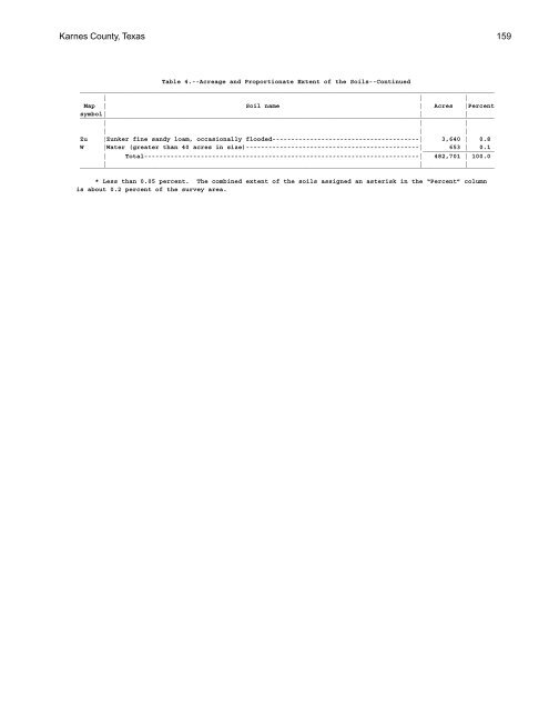
<strong>Karnes</strong> <strong>County</strong>, <strong>Texas</strong> 159 Table 4.--Acreage and Proportionate Extent <strong>of</strong> the <strong>Soil</strong>s--Continued ______________________________________________________________________________________________________________ | | | Map | <strong>Soil</strong> name | Acres |Percent symbol| ______________________________________________________________________________________________________________ | | | | | | | | Zu |Zunker fine sandy loam, occasionally flooded---------------------------------------| 3,640 | 0.8 W |Water (greater than 40 acres in size)----------------------------------------------| ___________________ 653 | 0.1 | Total-------------------------------------------------------------------------| 482,701 | 100.0 ______________________________________________________________________________________________________________ | | | * Less than 0.05 percent. The combined extent <strong>of</strong> the soils assigned an asterisk in the “Percent” column is about 0.2 percent <strong>of</strong> the survey area.
- Page 1:
United States Department of Agricul
- Page 4 and 5:
This soil survey is a publication o
- Page 6 and 7:
6 SrD—Shiner fine sandy loam, 1 t
- Page 9:
Foreword This soil survey contains
- Page 12 and 13:
12 Soil Survey College Station Aust
- Page 14 and 15:
14 miscellaneous area is associated
- Page 16 and 17:
16 Soil Survey Figure 2.—Typical
- Page 18 and 19:
18 Soil Survey Figure 4.—Typical
- Page 20 and 21:
20 Soil Survey Figure 6.—Typical
- Page 22 and 23:
22 Soil Survey Figure 7.—Typical
- Page 25 and 26:
25 Detailed Soil Map Units The map
- Page 27 and 28:
Karnes County, Texas 27 This Bryde
- Page 29 and 30:
Karnes County, Texas 29 texture of
- Page 31 and 32:
Karnes County, Texas 31 18 to 45 in
- Page 33 and 34:
Karnes County, Texas 33 This soil i
- Page 35 and 36:
Karnes County, Texas 35 in similar
- Page 37 and 38:
Karnes County, Texas 37 14 to 18 in
- Page 39 and 40:
Karnes County, Texas 39 stocking ra
- Page 41 and 42:
Karnes County, Texas 41 Subsoil: 12
- Page 43 and 44:
Karnes County, Texas 43 Important s
- Page 45 and 46:
Karnes County, Texas 45 grazing can
- Page 47 and 48:
Karnes County, Texas 47 sidewalls c
- Page 49 and 50:
Karnes County, Texas 49 44 to 54 in
- Page 51 and 52:
Karnes County, Texas 51 cropland, m
- Page 53 and 54:
Karnes County, Texas 53 Subsoil: 5
- Page 55 and 56:
Karnes County, Texas 55 capacity li
- Page 57 and 58:
Karnes County, Texas 57 Figure 9.
- Page 59 and 60:
Karnes County, Texas 59 Figure 10.
- Page 61 and 62:
Karnes County, Texas 61 This soil i
- Page 63 and 64:
Karnes County, Texas 63 and improve
- Page 65 and 66:
Karnes County, Texas 65 This soil i
- Page 67 and 68:
Karnes County, Texas 67 drainage di
- Page 69 and 70:
Karnes County, Texas 69 Runoff: hig
- Page 71 and 72:
Karnes County, Texas 71 Figure 12.
- Page 73 and 74:
Karnes County, Texas 73 controlled
- Page 75 and 76:
Karnes County, Texas 75 Figure 13.
- Page 77:
77 Prime Farmland Prime farmland is
- Page 80 and 81:
80 Soil Survey be absorbed by the s
- Page 82 and 83:
82 Soil Survey at three levels—ca
- Page 84 and 85:
84 Soil Survey climax plant species
- Page 86 and 87:
86 Soil Survey lovegrass grow near
- Page 88 and 89:
88 Soil Survey windmillgrass, sand
- Page 90 and 91:
90 Soil Survey burning are methods
- Page 92 and 93:
92 Soil Survey Shallow excavations
- Page 94 and 95:
94 Soil Survey cobbles and stones,
- Page 97 and 98:
97 Soil Properties Data relating to
- Page 99 and 100:
Karnes County, Texas 99 of undistur
- Page 101:
Karnes County, Texas 101 capacity,
- Page 104 and 105:
104 Soil Survey The soils of this s
- Page 106 and 107:
106 Soil Survey 1 or 2. These horiz
- Page 108 and 109: 108 Soil Survey county road, and 0.
- Page 110 and 111: 110 Soil Survey medium and coarse m
- Page 112 and 113: 112 Soil Survey Bt1—3 to 14 inche
- Page 114 and 115: 114 Soil Survey common prominent pr
- Page 116 and 117: 116 Soil Survey The 2BCtk horizon i
- Page 118 and 119: 118 Soil Survey medium mottles in s
- Page 120 and 121: 120 Soil Survey Figure 16.—Profil
- Page 122 and 123: 122 Soil Survey Figure 19.—Profil
- Page 124 and 125: 124 Soil Survey Figure 23.—Profil
- Page 126 and 127: 126 Soil Survey light brown in hue
- Page 128 and 129: 128 Soil Survey fine subangular blo
- Page 130 and 131: 130 Soil Survey noncalcareous, silt
- Page 132 and 133: 132 Soil Survey blocky structure; e
- Page 134 and 135: 134 Soil Survey Schattel Series The
- Page 136 and 137: 136 Soil Survey and medium angular
- Page 138 and 139: 138 Soil Survey Weesatche Series Th
- Page 141 and 142: 141 Formation of the Soils In this
- Page 143 and 144: Karnes County, Texas 143 volcanic a
- Page 145 and 146: 145 References (1) American Associa
- Page 147 and 148: 147 Glossary AC soil. A soil having
- Page 149 and 150: Karnes County, Texas 149 Erosion (g
- Page 151 and 152: Karnes County, Texas 151 gypsum or
- Page 153 and 154: Karnes County, Texas 153 soil textu
- Page 155 and 156: Tables 155
- Page 157: Karnes County, Texas 157 Table 2.--
- Page 161 and 162: Karnes County, Texas 161 Table 6.--
- Page 163 and 164: Karnes County, Texas 163 Table 6.--
- Page 165 and 166: Karnes County, Texas 165 Table 7.--
- Page 167 and 168: Karnes County, Texas 167 Table 8.--
- Page 169 and 170: Karnes County, Texas 169 Table 8.--
- Page 171 and 172: Karnes County, Texas 171 Table 9.--
- Page 173 and 174: Karnes County, Texas 173 Table 9.--
- Page 175 and 176: Karnes County, Texas 175 Table 10.-
- Page 177 and 178: Karnes County, Texas 177 Table 10.-
- Page 179 and 180: Karnes County, Texas 179 Table 11.-
- Page 181 and 182: Karnes County, Texas 181 Table 11.-
- Page 183 and 184: Karnes County, Texas 183 Table 12.-
- Page 185 and 186: Karnes County, Texas 185 Table 13.-
- Page 187 and 188: Karnes County, Texas 187 Table 13.-
- Page 189 and 190: Karnes County, Texas 189 Table 14.-
- Page 191 and 192: Karnes County, Texas 191 Table 14.-
- Page 193 and 194: Karnes County, Texas 193 Table 14.-
- Page 195 and 196: Karnes County, Texas 195 Table 14.-
- Page 197 and 198: Karnes County, Texas 197 Table 15.-
- Page 199 and 200: Karnes County, Texas 199 Table 15.-
- Page 201 and 202: Karnes County, Texas 201 Table 15.-
- Page 203 and 204: Table 16.--Soil and Water Features-
- Page 205 and 206: Table 16.--Soil and Water Features-
- Page 207 and 208: Table 17.--Physical Analyses of Sel
- Page 209 and 210:
Table 17.--Physical Analyses of Sel
- Page 211 and 212:
Table 18.--Chemical Analyses of Sel
- Page 213 and 214:
Karnes County, Texas 213 Table 19.-
- Page 215 and 216:
Karnes County, Texas 215 Table 20.-