

Soil Survey of Karnes County, Texas - Soil Data Mart - US ...
Soil Survey of Karnes County, Texas - Soil Data Mart - US ...
Soil Survey of Karnes County, Texas - Soil Data Mart - US ...

Create successful ePaper yourself
Turn your PDF publications into a flip-book with our unique Google optimized e-Paper software.
<strong>Karnes</strong> <strong>County</strong>, <strong>Texas</strong> 59<br />
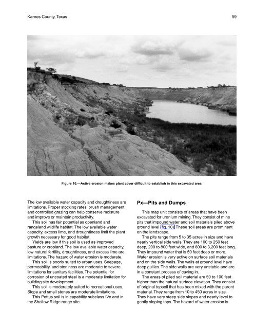
Figure 10.—Active erosion makes plant cover difficult to establish in this excavated area.<br />
The low available water capacity and droughtiness are<br />
limitations. Proper stocking rates, brush management,<br />
and controlled grazing can help conserve moisture<br />
and improve or maintain productivity.<br />
This soil has fair potential as openland and<br />
rangeland wildlife habitat. The low available water<br />
capacity, excess lime, and droughtiness limit the plant<br />
growth necessary for good habitat.<br />
Yields are low if this soil is used as improved<br />
pasture or cropland. The low available water capacity,<br />
low natural fertility, droughtiness, and excess lime are<br />
limitations. The hazard <strong>of</strong> water erosion is moderate.<br />
This soil is poorly suited to urban uses. Seepage,<br />
permeability, and stoniness are moderate to severe<br />
limitations for sanitary facilities. The potential for<br />
corrosion <strong>of</strong> uncoated steel is a moderate limitation for<br />
building site development.<br />
This soil is moderately suited to recreational uses.<br />
Slope and small stones are moderate limitations.<br />
This Pettus soil is in capability subclass IVe and in<br />
the Shallow Ridge range site.<br />
Px—Pits and Dumps<br />
This map unit consists <strong>of</strong> areas that have been<br />
excavated for uranium mining. They consist <strong>of</strong> mine<br />
pits that impound water and soil materials piled above<br />
ground level (fig. 10). These soil areas are prominent<br />
on the landscape.<br />
The pits range from 5 to 35 acres in size and have<br />
nearly vertical side walls. They are 100 to 250 feet<br />
deep, 200 to 800 feet wide, and 600 to 3,200 feet long.<br />
They impound water that is 50 feet deep or more.<br />
Water erosion is very active on surface soil materials<br />
and on the side walls. The walls at ground level have<br />
deep gullies. The side walls are very unstable and are<br />
in a constant process <strong>of</strong> caving in.<br />
The areas <strong>of</strong> piled soil material are 50 to 100 feet<br />
higher than the natural surface elevation. They consist<br />
<strong>of</strong> original topsoil that has been mixed with the parent<br />
material. They range from 10 to 450 acres in size.<br />
They have very steep side slopes and nearly level to<br />
gently sloping tops. The hazard <strong>of</strong> water erosion is


