

Soil Survey of Karnes County, Texas - Soil Data Mart - US ...
Soil Survey of Karnes County, Texas - Soil Data Mart - US ...
Soil Survey of Karnes County, Texas - Soil Data Mart - US ...

You also want an ePaper? Increase the reach of your titles
YUMPU automatically turns print PDFs into web optimized ePapers that Google loves.
22 <strong>Soil</strong> <strong>Survey</strong><br />
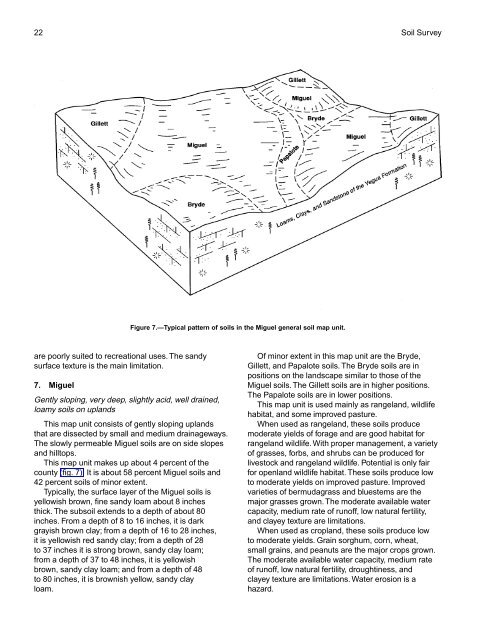
Figure 7.—Typical pattern <strong>of</strong> soils in the Miguel general soil map unit.<br />
are poorly suited to recreational uses. The sandy<br />
surface texture is the main limitation.<br />
7. Miguel<br />
Gently sloping, very deep, slightly acid, well drained,<br />
loamy soils on uplands<br />
This map unit consists <strong>of</strong> gently sloping uplands<br />
that are dissected by small and medium drainageways.<br />
The slowly permeable Miguel soils are on side slopes<br />
and hilltops.<br />
This map unit makes up about 4 percent <strong>of</strong> the<br />
county (fig. 7). It is about 58 percent Miguel soils and<br />
42 percent soils <strong>of</strong> minor extent.<br />
Typically, the surface layer <strong>of</strong> the Miguel soils is<br />
yellowish brown, fine sandy loam about 8 inches<br />
thick. The subsoil extends to a depth <strong>of</strong> about 80<br />
inches. From a depth <strong>of</strong> 8 to 16 inches, it is dark<br />
grayish brown clay; from a depth <strong>of</strong> 16 to 28 inches,<br />
it is yellowish red sandy clay; from a depth <strong>of</strong> 28<br />
to 37 inches it is strong brown, sandy clay loam;<br />
from a depth <strong>of</strong> 37 to 48 inches, it is yellowish<br />
brown, sandy clay loam; and from a depth <strong>of</strong> 48<br />
to 80 inches, it is brownish yellow, sandy clay<br />
loam.<br />
Of minor extent in this map unit are the Bryde,<br />
Gillett, and Papalote soils. The Bryde soils are in<br />
positions on the landscape similar to those <strong>of</strong> the<br />
Miguel soils. The Gillett soils are in higher positions.<br />
The Papalote soils are in lower positions.<br />
This map unit is used mainly as rangeland, wildlife<br />
habitat, and some improved pasture.<br />
When used as rangeland, these soils produce<br />
moderate yields <strong>of</strong> forage and are good habitat for<br />
rangeland wildlife. With proper management, a variety<br />
<strong>of</strong> grasses, forbs, and shrubs can be produced for<br />
livestock and rangeland wildlife. Potential is only fair<br />
for openland wildlife habitat. These soils produce low<br />
to moderate yields on improved pasture. Improved<br />
varieties <strong>of</strong> bermudagrass and bluestems are the<br />
major grasses grown. The moderate available water<br />
capacity, medium rate <strong>of</strong> run<strong>of</strong>f, low natural fertility,<br />
and clayey texture are limitations.<br />
When used as cropland, these soils produce low<br />
to moderate yields. Grain sorghum, corn, wheat,<br />
small grains, and peanuts are the major crops grown.<br />
The moderate available water capacity, medium rate<br />
<strong>of</strong> run<strong>of</strong>f, low natural fertility, droughtiness, and<br />
clayey texture are limitations. Water erosion is a<br />
hazard.


