The Granite Industry of Southwestern New Brunswick: A Historical ...
The Granite Industry of Southwestern New Brunswick: A Historical ...
The Granite Industry of Southwestern New Brunswick: A Historical ...

You also want an ePaper? Increase the reach of your titles
YUMPU automatically turns print PDFs into web optimized ePapers that Google loves.
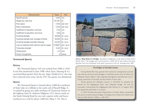
Part One — <strong>The</strong> St. George District 57<br />
Characteristic Value Unit<br />
Specific gravity 2.924 n/a<br />
Weight per cubic foot 181.557 lb<br />
Pore space 0.535 per cent<br />
Ratio <strong>of</strong> absorption 0.224 per cent<br />
Coefficient <strong>of</strong> saturation: one hour 0.45 n/a<br />
Coefficient <strong>of</strong> saturation: two hours 0.66 n/a<br />
Crushing strength 38,906 lb / sq in<br />
Crushing strength (wet, average <strong>of</strong> three) 35,620 lb / sq in<br />
Crushing strength (wet after freezing) 34,000 lb / sq in<br />
Loss on treatment with carbonic acid & oxygen 0.00607 gm / sq in<br />
Transverse strength 3,545 lb / sq in<br />
Drilling factor 5.5 mm<br />
Factor <strong>of</strong> toughness 9 blows<br />
Townsend Quarry<br />
History<br />
<strong>The</strong> Townsend Quarry (52) was worked from 1908 to 1910.<br />
It was first mentioned in June 1908, when Tayte, Meating & Co.<br />
excavated black granite from the site. Epps, Dodds & Co. also may<br />
have removed some stone, but by 1911 the quarry was abandoned.<br />
Quarry<br />
<strong>The</strong> Townsend Quarry is located about 2,000 feet southwest<br />
<strong>of</strong> Stein Lake on a hillside at the south end <strong>of</strong> Russell Ridge. It<br />
is reached by going two miles northeast <strong>of</strong> Chamcook Station on<br />
the highway from St. Andrews (Highway 127), thence north on<br />
the South Glenelg Road for one and a quarter miles and hence<br />
northwest on a trail for about 1,600 feet (Map 2, 52). This is<br />
Above: <strong>New</strong> River # 1 Bridge, situated on Highway 1 just west <strong>of</strong> <strong>New</strong> River<br />
Beach Park. <strong>The</strong> bridge was constructed in 1943–46 <strong>of</strong> red, black and grey<br />
granite from the Stillwater and other quarries in the St. George area. GM<br />
<strong>The</strong> Bridges <strong>of</strong> Charlotte County<br />
During World War Two, granite from several St. George-area quarries<br />
was used to construct stone bridges in Charlotte County. One <strong>of</strong> these, the<br />
Stillwater Quarry (Map 2, 49), originally belonged to manufacturer Levi H.<br />
Young, proprietor <strong>of</strong> the Bolt and Nut Works <strong>of</strong> Saint John.<br />
Young opened the Stillwater Quarry in mid-1874 on property he<br />
owned by the Digdeguash River near Stillwater Bridge. He and his<br />
associates incorporated the Digdeguash Red <strong>Granite</strong> Co. in August 1875<br />
but apparently sold little or no stone.<br />
In 1943 the <strong>New</strong> <strong>Brunswick</strong> Department <strong>of</strong> Public Works reactivated<br />
the quarry to build several bridges, including ones at <strong>New</strong> River Beach and<br />
Moores Mills (Martin 1990b, p. 206–207).