The Granite Industry of Southwestern New Brunswick: A Historical ...
The Granite Industry of Southwestern New Brunswick: A Historical ...
The Granite Industry of Southwestern New Brunswick: A Historical ...

Create successful ePaper yourself
Turn your PDF publications into a flip-book with our unique Google optimized e-Paper software.
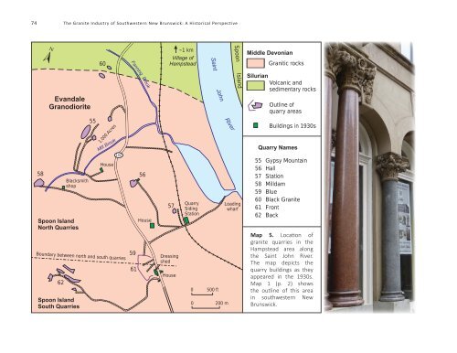
74 <strong>The</strong> <strong>Granite</strong> <strong>Industry</strong> <strong>of</strong> <strong>Southwestern</strong> <strong>New</strong> <strong>Brunswick</strong>: A <strong>Historical</strong> Perspective<br />
60<br />
~1 km<br />
Village <strong>of</strong><br />
Hampstead<br />
Middle Devonian<br />
Granitic rocks<br />
Saint<br />
Evandale<br />
Granodiorite<br />
Fanning<br />
Brook<br />
John<br />
Spoon Island<br />
Silurian<br />
Volcanic and<br />
sedimentary rocks<br />
Outline <strong>of</strong><br />
quarry areas<br />
58<br />
62<br />
Blacksmith<br />
shop<br />
Spoon Island<br />
North Quarries<br />
55<br />
1,000 Acres<br />
Mill Brook<br />
House<br />
102<br />
Boundary between north and south quarries<br />
Spoon Island<br />
South Quarries<br />
56<br />
House<br />
59<br />
61<br />
57<br />
Dressing<br />
shed<br />
House<br />
Quarry<br />
Siding<br />
Station<br />
0 500 ft<br />
River<br />
0 200 m<br />
Loading<br />
wharf<br />
Buildings in 1930s<br />
Quarry Names<br />
55 Gypsy Mountain<br />
56 Hall<br />
57 Station<br />
58 Milldam<br />
59 Blue<br />
60 Black <strong>Granite</strong><br />
61 Front<br />
62 Back<br />
Map 5. Location <strong>of</strong><br />
granite quarries in the<br />
Hampstead area along<br />
the Saint John River.<br />
<strong>The</strong> map depicts the<br />
quarry buildings as they<br />
appeared in the 1930s.<br />
Map 1 (p. 2) shows<br />
the outline <strong>of</strong> this area<br />
in southwestern <strong>New</strong><br />
<strong>Brunswick</strong>.