14th street and union square preservation plan - Columbia ...
14th street and union square preservation plan - Columbia ...
14th street and union square preservation plan - Columbia ...

You also want an ePaper? Increase the reach of your titles
YUMPU automatically turns print PDFs into web optimized ePapers that Google loves.
the West Side Highway that divides the Hudson River<br />
Park <strong>and</strong> 14 th Street.<br />
We propose to use design as a way to physically bridge<br />
the Pier 56 area with the High Line. The addition of<br />
a footbridge from the pier to the High Line would<br />
encourage <strong>and</strong> increase pedestrian traffic <strong>and</strong> thus<br />
increase the acknowledgement of this important historic<br />
resource. Secondly, the pier’s history should be recognized<br />
<strong>and</strong> interpreted in the redevelopment of the site. We<br />
have created a design that interprets the pier as both<br />
the unused place of the twentieth century by keeping it<br />
as an archaeological ruin, <strong>and</strong> as the important thriving<br />
pier of the late nineteenth century by the installation of<br />
historic plaques (Figure 17). Our proposal intervenes in<br />
a minimal way with the physical remains of the pier by<br />
adding a pedestrian ramp on which informational panels<br />
are located. The walk along the ramp in between the<br />
panels reveals images <strong>and</strong> facts pertaining to the history<br />
of the pier.<br />
Increasing recognition of the intrinsic design value of<br />
industrial sites, <strong>and</strong> the rich history they possess, has led<br />
cities around the country, <strong>and</strong> even around the world, to<br />
reclaim ab<strong>and</strong>oned industrial sites for public parks. New<br />
York City has demonstrated its willingness to reinvest in<br />
its own industrial past with the High Line Park project,<br />
<strong>and</strong> Pier 56 presents a natural extension of this effort.<br />
Example: Union Square Park<br />
Union Square is the most important <strong>and</strong> most highly used<br />
open space on 14 th Street. Its long history, connected<br />
with the development of the area, further emphasizes its<br />
importance to the study area. However, its history—both<br />
in the evolution of the park’s design <strong>and</strong> in the <strong>square</strong>’s<br />
relationship to the labor movement <strong>and</strong> surrounding<br />
buildings—has not been clearly expressed to the public.<br />
Though the park’s <strong>plan</strong>s have changed many times<br />
throughout its 150 year history, the use has remained<br />
generally the same within the park; it is the activity<br />
THE PLAN: ENHANCING INTERPRETATION OF OPEN SPACES<br />
<strong>and</strong> circulation patterns on the park’s perimeter that<br />
have seen the most change. Historically, the northern<br />
end of the park was used for public gatherings <strong>and</strong><br />
demonstrations; however since the renovation of the<br />
south end in the 1980’s, <strong>and</strong> with the Greenmarket in<br />
the north end, the stepped plaza has become the popular<br />
spot for gatherings today.<br />
After analysis of the current design, it was decided that<br />
the design proposals would focus on four objectives:<br />
first, that Union Square should be a place primarily<br />
for people, not for cars; second, that the evolution of<br />
the park’s designs need to be expressed to the public;<br />
third, that the park connect to its building context <strong>and</strong><br />
concurrent labor history; <strong>and</strong> fourth, that the park have<br />
a means of conveying its use as a political gathering<br />
space, in the past, <strong>and</strong> for current <strong>and</strong> future use.<br />
Objective 1: Circulation<br />
In order to ease the circulation conflicts throughout<br />
Union Square, the focus of the design should be the<br />
movement of people throughout the <strong>square</strong>, not the<br />
movement of automobile traffic on the <strong>street</strong>. Exp<strong>and</strong>ing<br />
the park’s boundaries to the north <strong>and</strong> the east solves<br />
many of the problems Union Square currently faces.<br />
The expansion creates one-way <strong>street</strong>s at Union Square<br />
East <strong>and</strong> 17 th Street, turning the <strong>street</strong>s around Union<br />
Square into a traffic circle <strong>and</strong> allowing easier <strong>and</strong> safer<br />
pedestrian crossings. The expansion allows more room<br />
for people to move around the perimeter of the park<br />
<strong>and</strong> also provides more space for the Greenmarket on<br />
three sides of the park. If, historically, the park was the<br />
only densely l<strong>and</strong>scaped space in Union Square, new<br />
proposals should maintain Olmsted’s intention that the<br />
park be a place of repose <strong>and</strong> isolation in the middle of<br />
the <strong>square</strong>.<br />
Objective 2: Evolution of park designs<br />
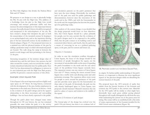
The formal <strong>plan</strong> of the design has evolved over the<br />
park’s 150-year history but there is no evidence left of<br />
18. PROPOSED MASTER PLAN FOR UNION SQUARE PARK.<br />
its origins. To further public underst<strong>and</strong>ing of the park’s<br />
history, it is important to illustrate the most significant<br />
aspects of the previous designs while not disturbing the<br />
current function of the park.<br />
The proposal layers the 1872 network of paths that<br />
radiate from the historic location of the fountain <strong>and</strong><br />
connects the 1872 paths to the current ones. Materials<br />
for the 1872 paths will be similar to what might have<br />
historically been used; grass cellular paving <strong>plan</strong>ted<br />
throughout will visually distinguish the old from the new,<br />
while maintaining the current use of the grassy areas for<br />
sitting. The center will be re-established with a flat circle<br />
of water, representative of the fountain installed for the<br />
1842 Croton water celebration (Figure 18).<br />
37