John Oxley Drive Precinct Structure Plan, July 2012 - Hastings ...
John Oxley Drive Precinct Structure Plan, July 2012 - Hastings ...
John Oxley Drive Precinct Structure Plan, July 2012 - Hastings ...

Create successful ePaper yourself
Turn your PDF publications into a flip-book with our unique Google optimized e-Paper software.
JOHN OXLEY DRIVE PRECINCT - <strong>Structure</strong> <strong>Plan</strong>, <strong>July</strong> <strong>2012</strong><br />
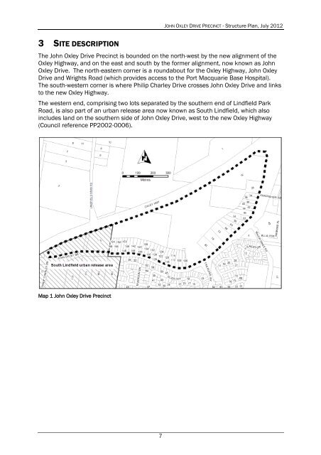
3 SITE DESCRIPTION<br />
The <strong>John</strong> <strong>Oxley</strong> <strong>Drive</strong> <strong>Precinct</strong> is bounded on the north-west by the new alignment of the<br />
<strong>Oxley</strong> Highway, and on the east and south by the former alignment, now known as <strong>John</strong><br />
<strong>Oxley</strong> <strong>Drive</strong>. The north-eastern corner is a roundabout for the <strong>Oxley</strong> Highway, <strong>John</strong> <strong>Oxley</strong><br />
<strong>Drive</strong> and Wrights Road (which provides access to the Port Macquarie Base Hospital).<br />
The south-western corner is where Philip Charley <strong>Drive</strong> crosses <strong>John</strong> <strong>Oxley</strong> <strong>Drive</strong> and links<br />
to the new <strong>Oxley</strong> Highway.<br />
The western end, comprising two lots separated by the southern end of Lindfield Park<br />
Road, is also part of an urban release area now known as South Lindfield, which also<br />
includes land on the southern side of <strong>John</strong> <strong>Oxley</strong> <strong>Drive</strong>, west to the new <strong>Oxley</strong> Highway<br />
(Council reference PP2002-0006).<br />
Map 1 <strong>John</strong> <strong>Oxley</strong> <strong>Drive</strong> <strong>Precinct</strong><br />
7