A National Interpretation of the High Conservation Value Forest ...
A National Interpretation of the High Conservation Value Forest ...
A National Interpretation of the High Conservation Value Forest ...
You also want an ePaper? Increase the reach of your titles
YUMPU automatically turns print PDFs into web optimized ePapers that Google loves.
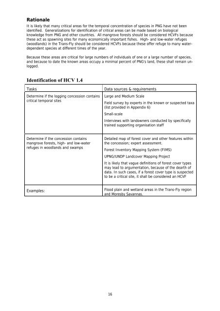
Rationale<br />
It is likely that many critical areas for <strong>the</strong> temporal concentration <strong>of</strong> species in PNG have not been<br />
identified. Generalizations for identification <strong>of</strong> critical areas can be made based on biological<br />
knowledge from PNG and o<strong>the</strong>r countries. All mangrove forests should be considered HCVFs because<br />
<strong>the</strong>se act as spawning sites for many economically important fishes. <strong>High</strong>- and low-water refuges<br />
(woodlands) in <strong>the</strong> Trans-Fly should be considered HCVFs because <strong>the</strong>se <strong>of</strong>fer refuge to many waterdependent<br />
species at different times <strong>of</strong> <strong>the</strong> year.<br />
Because <strong>the</strong>se areas are critical for large numbers <strong>of</strong> individuals <strong>of</strong> one or a large number <strong>of</strong> species,<br />
and because to date <strong>the</strong> known areas occupy a minimal percent <strong>of</strong> PNG’s land, <strong>the</strong>se shall remain unlogged.<br />
Identification <strong>of</strong> HCV 1.4<br />
Tasks<br />
Determine if <strong>the</strong> logging concession contains<br />
critical temporal sites<br />
Data sources & requirements<br />
Large and Medium Scale<br />
Field survey by experts in <strong>the</strong> known or suspected taxa<br />
(list provided in Appendix 6)<br />
Small-scale<br />
Interviews with landowners conducted by specifically<br />
trained supporting organisation staff<br />
Determine if <strong>the</strong> concession contains<br />
mangrove forests, high- and low-water<br />
refuges in woodlands and swamps<br />
Detailed map <strong>of</strong> forest cover and o<strong>the</strong>r features within<br />
<strong>the</strong> concession; expert assessment.<br />
<strong>Forest</strong> Inventory Mapping System (FIMS)<br />
UPNG/UNDP Landcover Mapping Project<br />
It is likely that vague definitions <strong>of</strong> forest cover types<br />
may lead to argumentation, because <strong>of</strong> <strong>the</strong> dearth <strong>of</strong><br />
data. In such cases, if a forest cover type is suspected<br />
to be a critical site, it shall be considered an HCVF<br />
Examples:<br />
Flood plain and wetland areas in <strong>the</strong> Trans-Fly region<br />
and Moresby Savannas.<br />
16


