Water Resource Publication Airport Dam 4A OPP-WRP-DM-4A:(1 ...
Water Resource Publication Airport Dam 4A OPP-WRP-DM-4A:(1 ...
Water Resource Publication Airport Dam 4A OPP-WRP-DM-4A:(1 ...

Create successful ePaper yourself
Turn your PDF publications into a flip-book with our unique Google optimized e-Paper software.
Introduction<br />
<strong>Water</strong> <strong>Resource</strong> <strong>Publication</strong><br />
<strong>Airport</strong> <strong>Dam</strong> <strong>4A</strong><br />
<strong>OPP</strong>-<strong>WRP</strong>-<strong>DM</strong>-<strong>4A</strong>:(1)-2007<br />
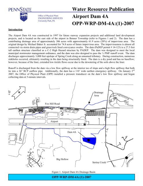
The <strong>Airport</strong> <strong>Dam</strong> <strong>4A</strong> was constructed in 1997 for future runway expansion projects and additional land development<br />
projects, and is located on the east side of the airport in Benner Township (refer to Figures 1 and 2). The dam has a<br />
contributing drainage area of approximately 306 acres with approximately 61.9 acres (20%) of impervious area. The<br />
original design by Michael Baker Jr. accounted for 74.8 acres of future impervious area. The imperviousness is almost all<br />
connected via storm drain pipes and grass/rock lined conveyance swales. The dam (PaDEP permit # 14-123) is a 27.5 feet<br />
tall earthen structure classified as a C-2 High Hazard structure by PADEP. The dam was designed to meet the local<br />
municipal stormwater management ordinance, and the dam was also designed to pass the ½ PMF runoff event. The dam<br />
discharges approximately 3,000 feet upslope of Spring Creek along an unnamed tributary. During construction, numerous<br />
sinkholes occurred, ultimately resulting in the dam being structurally lined. The dam is a dry pond and has no baseflow;<br />
however, because of the liner, extended low trickle flows occur due to the dewatering of the soils above the liner.<br />
Runoff is discharged from the dam via a low flow spillway at the interior toe of slope and a high flow spillway that both<br />
tie into a 36” RCP outflow pipe. Additionally, the dam has a 110’ wide earthen emergency spillway. On January 2 nd<br />
2007, the Office of Physical Plant (<strong>OPP</strong>) installed a pressure transducer on the dam’s low flow spillway and began<br />
collecting data at 5-minute intervals.<br />
N<br />
Drainage<br />
Area<br />
Fox Hill Road<br />
<strong>Airport</strong><br />
<strong>Dam</strong> <strong>4A</strong><br />
Big Hollow<br />
Spring Creek<br />
Figure 1. <strong>Airport</strong> <strong>Dam</strong> <strong>4A</strong> Drainage Basin<br />
<strong>OPP</strong>-<strong>WRP</strong>-<strong>DM</strong>-<strong>4A</strong>:(1)-2007
Penn State University<br />
<strong>Water</strong> <strong>Resource</strong> <strong>Publication</strong><br />
Soils and Geology<br />
Figure 2. Photograph of <strong>Dam</strong> <strong>4A</strong> with High Flow Spillway Shown in the Foreground<br />
The majority of the <strong>Dam</strong>’s drainage basin soils are identified as the Hublersburg Silt Loam Series by the Soil Survey of<br />
Centre County. The Hublersburg series consists of deep, well-drained soils that formed in cherty limestone residuum.<br />
The most significant limitation identified in the soil survey for Hublersburg soils is possible sinkhole formation. The dam<br />
was built near a small area of Hagerstown Silty Clay Loam. Hublersburg soils have a hydrologic soil group (HSG) B as<br />
defined by the USDA NRCS.<br />
The basin is underlain by bedrock of the Mines Member of the Gatesburg Formation and the Lower Member of the<br />
Gatesburg Formation undivided. The geologic contact between these two formations runs parallel and south of the<br />
runways splitting the basin.<br />
Hydrologic Response<br />
The low flow spillway has a series of four 3” diameter holes located 2 feet below the normal basin ground elevation to<br />
dewater soils above the liner. These holes are partially blocked by large boulders. The pressure transducer is located at<br />
the elevation of these four under drain holes; however, minor trickle flows through the holes cannot be determined<br />
accurately. These holes have no significant effect on the larger event peak runoff rates or runoff volumes.<br />
The During the year 2007, 35.9 inches of rainfall were measured at the Walker Building; however, 44.2” of rainfall were<br />
recorded at the <strong>Airport</strong> Weather Station (KUNV) located within the drainage basin. The precipitation resulted in 32<br />
runoff events being measured at the dam’s outflow pipe (refer to Figure 3). The total annual runoff volume discharged<br />
from the dam was 117.45 ac-ft, or 4.6 watershed inches. This runoff volume equates to 12.8% of the annual precipitation<br />
at the Walker Building or 10.4% of the annual precipitation at the <strong>Airport</strong>.<br />
As would be expected, four precipitation events (3/2, 8/8, 8/21, and 12/24) resulted in generating a significant amount of<br />
the runoff volume equivalent to 51.0 ac-ft or 2.0 watershed inches, which represented 43% of the total annual runoff<br />
volume. These four precipitation events had a total of 6.93” of rainfall, or 15.6% of the total annual precipitation.<br />
<strong>OPP</strong>-<strong>WRP</strong>-<strong>DM</strong>-<strong>4A</strong>:(1)-2007
Penn State University<br />
<strong>Water</strong> <strong>Resource</strong> <strong>Publication</strong><br />
1131<br />
1129<br />
1127<br />
1125<br />
Stage (ft)<br />
1123<br />
1121<br />
1119<br />
1117<br />
1115<br />
1113<br />
1/1/2007 4/1/2007 6/30/2007 9/28/2007 12/27/2007<br />
Date<br />
Significant Runoff Events of 2007<br />
Figure 3. Discharge from <strong>Dam</strong> <strong>4A</strong> from 1/2/2007 to 12/31/2007<br />
Five precipitation events over 1 inch in depth occurred during 2007, the largest being 2.76” of rainfall on August 21st.<br />
These five precipitation events and a small rainfall event on snow (March 2 nd ) are shown in the table below along with<br />
the event peak runoff rates and runoff volumes.<br />
Walker <strong>Airport</strong> Max<br />
Event Event WSE Outlet Out Out<br />
Date P (in) P (in) (ft) Qp (cfs) Q (ac-ft) Q (in)<br />
3/2/2007 0.53 0.88 1124.2 5.9 20.8 0.8<br />
6/4/2007 1.01 1.13 1116.7 3.9 1.6 0.1<br />
7/12/2007 1.09 0.47 1114.5 2.3 0.3 0.0<br />
8/8/2007 1.21 1.10 1121 5.1 7.0 0.3<br />
8/21/2007 2.18 2.76 1117.9 4.3 7.1 0.3<br />
12/24/2007 1.02 2.19 1124.4 6.0 16.1 0.6<br />
The minor rainfall event of March 2 nd occurred with an average of 3” of snow on the ground and resulted in the highest<br />
annual runoff volume. The highest peak runoff rate was generated from the December 24 th precipitation event, which was<br />
a high intensity event with approximately 1.4” of rainfall occurring over a 4-hour period. While these two events<br />
represent completely different hydrologic conditions, the resulting extended hydrologic responses in the dam were similar<br />
(compared Figures 4 and 5). This is most likely due to the drainage basin’s time of concentration and the low and fairly<br />
constant discharge from the dam’s low flow spillway. The dam’s discharge at elevation 1131 (representing 18 feet of<br />
head and 41.4 ac-ft of storage) is only approximately 14.5 cfs.<br />
<strong>OPP</strong>-<strong>WRP</strong>-<strong>DM</strong>-<strong>4A</strong>:(1)-2007
Penn State University<br />
<strong>Water</strong> <strong>Resource</strong> <strong>Publication</strong><br />
1131.0<br />
1129.0<br />
1127.0<br />
1125.0<br />
Stage (ft)<br />
1123.0<br />
1121.0<br />
1119.0<br />
1117.0<br />
1115.0<br />
1113.0<br />
1111.0<br />
3/1/07 0:00 3/2/07 0:00 3/3/07 0:00 3/4/07 0:00 3/5/07 0:00<br />
Date<br />
Figure 4. Runoff Event of March 2, 2007<br />
1131.0<br />
1129.0<br />
1127.0<br />
1125.0<br />
Stage (ft)<br />
1123.0<br />
1121.0<br />
1119.0<br />
1117.0<br />
1115.0<br />
1113.0<br />
1111.0<br />
12/22/07 0:00 12/23/07 0:00 12/24/07 0:00 12/25/07 0:00 12/26/07 0:00<br />
Date<br />
Figure 5. Runoff Event of December 24, 2007<br />
<strong>OPP</strong>-<strong>WRP</strong>-<strong>DM</strong>-<strong>4A</strong>:(1)-2007
Penn State University<br />
<strong>Water</strong> <strong>Resource</strong> <strong>Publication</strong><br />
<strong>Water</strong> Quality, Thermal and Recharge Issues<br />
No water quality sampling of surface water was conducted during the record period. Because there is no baseflow within<br />
the Basin, and it is unknown at this time how much of the dam’s discharges are infiltrated downslope prior to reaching<br />
Spring Creek, the thermal impact is not know. However, since the runoff volumes are so small compared to stream flow<br />
within Spring Creek, the thermal impacts are assumed to be negligible. This topic may be explored more in the future as<br />
additional data are collected.<br />
Miscellaneous Information<br />
<strong>Dam</strong> Permit Number: 14-123<br />
Design storm: ½ PMF<br />
Interior Embankment Bottom Elevation = 1113.00<br />
Emergency Spillway Elevation = 1131.60<br />
Top of <strong>Dam</strong> Elevation = 1135.00<br />
Surface Drainage Basins: Spring Creek/Bald Eagle Creek/West Branch Susquehanna River<br />
PA Title 25, Chapter 93 <strong>Water</strong> Quality Classification: High Quality-Cold <strong>Water</strong> Fishery (HQ-CWF)<br />
USGS Quadrangle: State College<br />
Hydrologic Unit Code: 02050204<br />
Latitude/Longitude: 40° 51’ 15” / 77° 50’ 00”<br />
Municipalities: Benner Township<br />
Publisher: Penn State University, Office of Physical Plant, Energy and Engineering Division, Engineering Services<br />
Editor: Larry Fennessey, <strong>OPP</strong> Stormwater Engineer, Ph: (814) 863-8743, email: laf8@psu.edu<br />
<strong>OPP</strong>-<strong>WRP</strong>-<strong>DM</strong>-<strong>4A</strong>:(1)-2007