High Wind Drag Coefficient and Sea Surface Roughness in Shallow ...
High Wind Drag Coefficient and Sea Surface Roughness in Shallow ...
High Wind Drag Coefficient and Sea Surface Roughness in Shallow ...

Create successful ePaper yourself
Turn your PDF publications into a flip-book with our unique Google optimized e-Paper software.
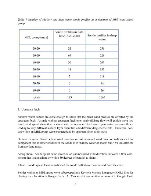
Table 1 Number of shallow <strong>and</strong> deep water sonde profiles as a function of MBL w<strong>in</strong>d speed<br />
group.<br />
MBL group (m/s)<br />
Sonde profiles <strong>in</strong> database<br />
(3-20-2006)<br />
Sonde profiles <strong>in</strong> deep<br />
water<br />
20-29 32 256<br />
30-39 65 229<br />
40-49 30 207<br />
50-59 18 133<br />
60-69 5 118<br />
70-79 0 94<br />
80-89 0 26<br />
totals 143 1063<br />
3. Upstream fetch<br />
<strong>Shallow</strong> water sondes are close enough to shore that the mean w<strong>in</strong>d profiles are affected by the<br />
upstream fetch. A sonde with an upstream fetch over l<strong>and</strong> (offshore flow) will exhibit more low<br />
level w<strong>in</strong>d speed shear than a sonde with an upstream fetch over open water (onshore flow),<br />
lead<strong>in</strong>g to very different surface layer quantities <strong>and</strong> different drag coefficients. Therefore sondes<br />
with<strong>in</strong> an MBL group were characterized by upstream fetch as follows:<br />
Onshore or open: Sonde splash w<strong>in</strong>d direction or last measured w<strong>in</strong>d direction <strong>in</strong>dicates a flow<br />
component that is either onshore or the sonde is <strong>in</strong> shallow water or shoals but > 50 km offshore<br />
from any l<strong>and</strong> mass.<br />
Along-shore: Sonde splash w<strong>in</strong>d direction or last measured w<strong>in</strong>d direction <strong>in</strong>dicates a flow component<br />
that is alongshore or with<strong>in</strong> 30 degrees of parallel to shore.<br />
Inl<strong>and</strong>: Sonde splash location <strong>in</strong>dicated the sonde drifted over l<strong>and</strong> <strong>in</strong>l<strong>and</strong> from the coast.<br />
Sondes with<strong>in</strong> an MBL group were subgrouped <strong>in</strong>to Keyhole Markup Language (KML) files for<br />
plott<strong>in</strong>g their location <strong>in</strong> Google Earth. A JAVA servlet was written to connect to Google Earth<br />
2