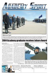
2008-2009 Catalog - United States Air Force Academy
2008-2009 Catalog - United States Air Force Academy
2008-2009 Catalog - United States Air Force Academy

Create successful ePaper yourself
Turn your PDF publications into a flip-book with our unique Google optimized e-Paper software.
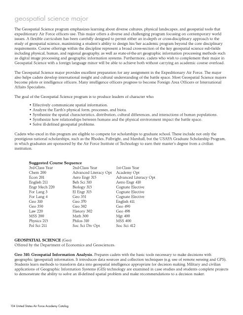
geospatial science major<br />
The Geospatial Science program emphasizes learning about diverse cultures, physical landscapes, and geospatial tools that<br />
expeditionary <strong>Air</strong> <strong>Force</strong> officers use. This major offers a diverse and challenging program focusing on contemporary world<br />
issues. A flexible curriculum has been carefully designed to permit either an in-depth or cross-disciplinary approach to the<br />
study of geospatial science, maximizing a student’s ability to design his/her academic program beyond the core disciplinary<br />
requirements. Course offerings within the discipline represent a broad cross-section of the key geospatial science sub-fields<br />
including physical, human, and regional geography, as well as state-of-the-art geographic information processing methods such<br />
as digital image processing and geographic information systems. Furthermore, cadets who wish to complement their major in<br />
Geospatial Science with a foreign language minor will be able to achieve both without carrying an academic course overload.<br />
The Geospatial Science major provides excellent preparation for any assignment in the Expeditionary <strong>Air</strong> <strong>Force</strong>. The major<br />
also helps cadets develop international insight and cultural understanding of the battle space. Most Geospatial Science majors<br />
become pilots or intelligence officers. Many intelligence officers progress to become Foreign Area Officers or International<br />
Affairs Specialists.<br />
The goal of the Geospatial Science program is to produce leaders of character who:<br />
• Effectively communicate spatial information.<br />
• Analyze the Earth’s physical form, processes, and biota.<br />
• Synthesize the spatial characteristics, distribution, cultural differences, and interactions of human populations.<br />
• Synthesize how relationships between humans and the physical environment impact the battle space.<br />
• Solve ill-defined geospatial problems.<br />
Cadets who excel in this program are eligible to compete for scholarships to graduate school. These include not only the<br />
prestigious national scholarships, such as the Rhodes, Fulbright, and Marshall, but the USAFA Graduate Scholarship Program,<br />
in which graduates are sponsored by the <strong>Air</strong> <strong>Force</strong> Institute of Technology to earn their master’s degree from a civilian<br />
institution.<br />
Suggested Course Sequence<br />
3rd-Class Year 2nd-Class Year 1st-Class Year<br />
Chem 200 Advanced Literacy Opt <strong>Academy</strong> Opt<br />
Econ 201 Aero Engr 315 Advanced Literacy Opt<br />
English 211 Beh Sci 310 Astro Engr 410<br />
Engr Mech 220 Biology 315 Cognate Elective<br />
For Lang 3 El Engr 315 Cognate Elective<br />
For Lang 4 Geo 351 Cognate Elective<br />
Geo 310 Geo 370 English 411<br />
Geo 350 Geo 382 Geo 490<br />
Law 220 History 302 Geo 498<br />
MSS 200 Math 300 Mgt 400<br />
Physics 215 Philos 310 MSS 400<br />
Pol Sci 211 Soc Sci Div Opt Soc Sci 412<br />
GEOSPATIAL SCIENCE (Geo)<br />
Offered by the Department of Economics and Geosciences.<br />
Geo 310. Geospatial Information Analysis. Prepares cadets with the basic tools necessary to make decisions with<br />
geographic (geospatial) information. It introduces data sources and collection techniques (e.g. use of remote sensing and GPS).<br />
Students learn methods to transform data into geospatial intelligence appropriate for decision making. Military and civilian<br />
applications of Geographic Information Systems (GIS) technology are examined in case studies and students complete projects<br />
to demonstrate the ability to solve an ill-defined spatial problem and make recommendations to a decision maker.<br />
104 <strong>United</strong> <strong>States</strong> <strong>Air</strong> <strong>Force</strong> <strong>Academy</strong> <strong>Catalog</strong>