No information found
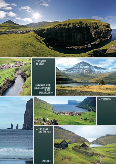
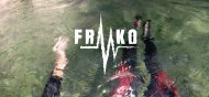
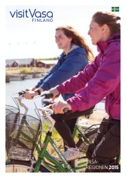
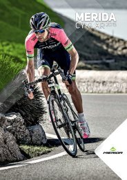
GJÓGV and other attractions in the area Tjörnuvík Saksun Eiði Gjógv The most photographed village in the Faroes is probably Gjógv, which is located in the northernmost part of Eysturoy. In order to reach Gjógv you will have to cross a high mountain ridge from where you will see a large green valley with striking mountains on both sides. At the very bottom of the valley, the colourful houses are dotted around a beautiful crystal-clear river with a little dam where children play all summer. But the village is best known for its natural harbour. Gjógv means gorge in Faroese and it is precisely in the great gorge cutting into the landscape that the natural harbour is located. Take all the steps down into the gorge, down to the harbour and take in the immense power of nature in surroundsound. The coastal area where the village is located is low, however, eastwards, towards Múli, and onwards around this headland to the southeastern coast, the coast rises steeply from the sea. In the other direction, a deep valley stretches down towards the village and almost parallel to it, across the ridge, you will find another of nature’s gems, Ambadalur valley. The hike to Ambadalur is one of the most popular in the Faroes and is rewarded with the view of the tallest freestanding cliff column in the Faroes called Búgvin. There are two roads to Gjógv and, to make the most of the trip, you could take one on the way to the village and the other when you depart. If you are out exploring in your own vehicle, you should make the most of it and do the whole itinerary with Funningur, Gjógv, Slættaratindur, Risin and Kellingen, Tjörnuvík and Saksun. This would be a full day-trip leaving you with lasting impressions of magnificent landscapes and lots of fresh air. Funningur is located in the fiord Funningsfjörður, it is a charming little village that has a beautiful traditional church built in 1847 with tarred walls, grass clad roof and a bell tower. The village is at the bottom of a valley and the homes here follow along the river streaming down from the steep surrounding mountains. From Funningur you travel up along the mountain road to Gjógv. Having visited Funningur and Gjógv the mountains beckon, because this is where you will find the highest mountains in the archipelago. Slættaratindur with its 882 metres is the tallest and next to it towers Gráfelli with its 857 metres as the second tallest mountain in the Faroes. If you take the mountain road from Gjógv to Eiði, you will drive through the pass between Slættaratindur and Gráfelli. You will already be around 400 metres above sea level here, so the hike all the way up to Slættaratindur’s summit is not as strenuous as it might otherwise seem. This is probably also why so many can boast that they have been to the summit of the Faroes where the view is dazzling. When the skies are clear, the view from Slættaratindur’s summit spans all 18 islands making up the Faroes – or almost at least. Off Eysturoy’s northern coast you will spot the sea stacks Risin and Kellingin. Legend has it that the giant, Risin, <strong>FAROE</strong> <strong>ISLANDS</strong> S and the hag, Kellingin, were on a mission from Iceland to steal the Faroes and haul them up to Iceland. Giants and hags are, of course, creatures of the night and they knew that they had to hurry before the sun came up. Unfortunately for them, they were so consumed by their task this one night that they did not reach shelter before the sun’s first rays hit team and turned them to stone. Since then, the pair has stood there gazing longingly towards their home country. Eiðiskoltur, the mountain where they fastened their rope, still bears the mark of their work, as the cliff cracked when they tugged on the rope in their futile efforts. Risin and Kellingin can be admired from both Slættaratindur and Tjörnuvík, but the best vantage point is from the road between Slættaratindur and Eiði. A telescope is available there for you to take a closer look at these mysterious creatures. Tjörnuvík in northern Streymoy is a pretty little village in a cove girded by tall mountains; in fact, the mountains are so tall that they block out all direct sunlight for a couple of months every winter. Tjörnuvík has a large sandy beach with a view over the sea stacks Risin and Kellingen off the northernmost point of Eysturoy. Tjörnuvík is also known for its musical heritage, here, villagers have remained faithful to the old singing traditions and still sing hymns in the old Kingo style. Saksun is one of the archipelago’s great surprises. In order to reach Saksun, you have to drive through a long valley from the village Hvalvík. After driving past the picturesque lake, Saksunarvatn, the village suddenly emerges from the landscape. A deep ravine runs through the village and you will have to stay on its right to reach the smallest neighbourhood where there is a wonderful little museum, Dúvugarður, which will allow you to catch a rare glimpse of what life was like on a farm in the old days. This is also where you will find the beautiful chalked church with a grass roof clinging to the mountain rim. If, on the other hand, you choose to turn left, the road will take you through the village and from here you should continue on foot into the immense stunning bay. There is a sandy beach in the bay itself, and, when the tide is low, you can walk out through the bay, along the beach, and out towards the even larger sandy beach, which faces the Atlantic unguarded. Do remember the tidal times, though, as you will not be able to walk along the beach out through the bay, or back again, when the tide is high. 13