(PIC) Protocol Manual - Kitsap Public Health District
(PIC) Protocol Manual - Kitsap Public Health District
(PIC) Protocol Manual - Kitsap Public Health District

You also want an ePaper? Increase the reach of your titles
YUMPU automatically turns print PDFs into web optimized ePapers that Google loves.
<strong>Kitsap</strong> <strong>Public</strong> <strong>Health</strong> <strong>District</strong><br />
Pollution Source Identification and Correction: <strong>Protocol</strong> <strong>Manual</strong><br />
NOTE: If necessary, a composite sample may be collected when there are multiple small discharges that<br />
appear to emanate from one parcel and/or are close together.<br />
Sometimes discharges are too small to sample without capturing underlying sediment. This is not a<br />
significant problem - simply try to minimize the amount of sediment collected.<br />
• Note any unusual odors, matting, vegetative growth, laundry lint, food waste, temperature,<br />
animal tracks, animal waste, or any other characteristics that may indicate a sewage or laundry<br />
source at or near the water sample.<br />
• Wash hands as soon as possible after sampling and before you eat.<br />
Labeling and Recording samples:<br />
• Use a black permanent marker (or regular pen) to label the 100 milliliter sample bottle with the<br />
sample identifier, date, and time the sample was collected on the label.<br />
• Clearly record the sample name, collection time, location, drainage size, pipe diameter, and pipe<br />
material (if applicable) in the field notebook.<br />
• Record detailed parcel-oriented sample descriptions in the field notebook so that outfalls can be<br />
resampled by different staff, if necessary.<br />
• Note any characteristics that will help distinguish the property when accessed from upland so<br />
that the outfall can be easily found for resampling and the associated property address can be<br />
identified, if necessary.<br />
• Record latitude and longitude of the discharge with a GPS unit and take digital photographs.<br />
• Photographs are helpful for re-identification of sample stations during subsequent surveys.<br />
• Generally one partner will collect the water sample and photo and the other will record field<br />
notes and GPS coordinates.<br />
• Enter the sample information in the field notebook.<br />
• Print the Project Name at the top of the page, the start/end locations, include the date, staff<br />
initials and the weather and tide conditions. An example of the field notebook entry is shown<br />
below:<br />
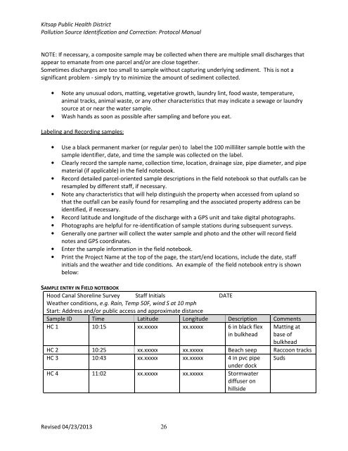
SAMPLE ENTRY IN FIELD NOTEBOOK<br />
Hood Canal Shoreline Survey Staff Initials DATE<br />
Weather conditions, e.g. Rain, Temp 50F, wind S at 10 mph<br />
Start: Address and/or public access and approximate distance<br />
Sample ID Time Latitude Longitude Description Comments<br />
HC 1 10:15 xx.xxxxx xx.xxxxx 6 in black flex<br />
in bulkhead<br />
Matting at<br />
base of<br />
bulkhead<br />
HC 2 10:25 xx.xxxxx xx.xxxxx Beach seep Raccoon tracks<br />
HC 3 10:43 xx.xxxxx xx.xxxxx 4 in pvc pipe Suds<br />
under dock<br />
HC 4 11:02 xx.xxxxx xx.xxxxx Stormwater<br />
diffuser on<br />
hillside<br />
Revised 04/23/2013 26