Flora & Fauna Survey & Ecological Assessment (pdf. 5MB)
Flora & Fauna Survey & Ecological Assessment (pdf. 5MB)
Flora & Fauna Survey & Ecological Assessment (pdf. 5MB)

You also want an ePaper? Increase the reach of your titles
YUMPU automatically turns print PDFs into web optimized ePapers that Google loves.
<strong>Flora</strong> & <strong>Fauna</strong> <strong>Survey</strong> & <strong>Ecological</strong> <strong>Assessment</strong>s – 35 Water Street Wahroonga<br />
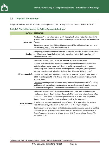
2.2 Physical Environment<br />
The physical characteristics of the Subject Property and the Locality have been summarised in Table 2.3.<br />
Table 2.2: Physical Features of the Subject Property & Environs 6<br />
FEATURE DESCRIPTION<br />
Topography<br />
Geology<br />
Soil Landscape Unit<br />
Local Hydrology<br />
The Subject Property is located on gently sloping land, with a moderately steep (10%)<br />
gradient from north-west to south-east – downslope towards Young Street and Billyard<br />
Avenue.<br />
Site elevation ranges from 200m AHD at the top to 176m AHD at the lower southern<br />
site boundary, sloping towards Billyard Avenue.<br />
The geology has been mapped as Ashfield Shale (Rwa), which is a unit (or substrate) of<br />
the Wianamatta Group Shales. It typically comprises black to dark-grey shale and<br />
laminite (Herbert 1983).<br />
The Subject Property is located on the Glenorie (gn) Soil Landscape Unit.<br />
Glenorie soils are erosional landscapes, comprising shallow to moderately deep red<br />
podzolic soils on crests, moderately deep red and brown podzolic soils on upper<br />
slopes, deep yellow podzolic soils on lower slopes and humic gleys, yellow podzolic<br />
soils and gleyed podzolic soils along drainage lines (Chapman & Murphy 1989).<br />
Glenorie Soil Landscape comprises undulating to rolling low hills with a local relief of<br />
50-80 m, and slopes of 5-20%. Ridges, hillcrests and valleys are narrow (Chapman &<br />
Murphy 1989).<br />
Limitations: As the gardens at Rippon Grange were developed in the late 19 th Century,<br />
and have until recently been maintained as a managed landscape, it may be assumed<br />
that the native soil profile described above has been extensively modified.<br />
The Subject Property is located with the Lovers Jump Creek sub-catchment of the<br />
Hawkesbury-Nepean Catchment (see Table 1.1). There is no external catchment inflow<br />
to the site. There are no natural drainage lines within, or in close proximity to the<br />
Subject Property. Runoff drains generally overland, to the south-east.<br />
An ephemeral man-made drainage line runs from north to south along the western<br />
side of the driveway in the south-eastern portion of the Subject Property.<br />
Existing stormwater drainage is limited to the developed areas, and consists of building<br />
roof drainage and sparsely located surface inlet pits on pavement, with discharge to<br />
Council’s stormwater system at Billyard Avenue (LHO Group, Drainage Concept Plan<br />
November 2007).<br />
6 Information in Table 2.3 has been sourced from the Vegetation Management Plan UBM 2007<br />
UBM <strong>Ecological</strong> Consultants Pty Ltd Page 15