District Plan - Isthmus Section: Appendix B ... - Auckland Council
District Plan - Isthmus Section: Appendix B ... - Auckland Council
District Plan - Isthmus Section: Appendix B ... - Auckland Council

You also want an ePaper? Increase the reach of your titles
YUMPU automatically turns print PDFs into web optimized ePapers that Google loves.
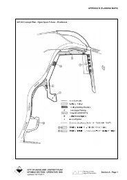
APPENDIX B (PLANNING MAPS)<br />
C08-27 CONCEPT PLAN - KARANGAHAPE<br />
ROAD PLAZA<br />
DOMINANT ACTIVITIES<br />
Area A - Residential<br />
Area B - Office<br />
Area C - Retail Fronting Karangahape Road<br />
PERMITTED ACTIVITIES<br />
Area A<br />
• Ancillary activities to any permitted activity<br />
• Home occupations<br />
• Healthcare services<br />
• Residential units<br />
• Restaurants, cafes and other eating places.<br />
Area B<br />
• Ancillary activities to any permitted activity<br />
• Care centres<br />
• Education facility<br />
• Healthcare services<br />
• Visitor Accommodation<br />
• Offices<br />
• Retail<br />
• Restaurants, cafes and other eating places<br />
• Tavern<br />
• Workrooms<br />
Area C<br />
• Any activity listed as a permitted activity in the<br />
Business 2 zone in Rule 8.7.1 ACTIVITIES IN<br />
BUSINESS 1,2,3,4,5,5A AND 6 ZONES.<br />
• Taverns<br />
DEVELOPMENT CONTROLS<br />
All development is subject to the development controls of<br />
Clause 8.8.3 DEVELOPMENT CONTROLS FOR THE<br />
BUSINESS 8 ZONE except where specified otherwise<br />
on the Concept <strong>Plan</strong>.<br />
1. Building Platform<br />
Building development is limited to the building<br />
platforms illustrated on the Concept <strong>Plan</strong>.<br />
2. Maximum Height<br />
Area B -<br />
Area C - 12.5 metres<br />
3. Maximum Gross Floor Area<br />
Area A<br />
The maximum total aggregate gross floor area for<br />
permitted activities other then residential units and<br />
home occupations shall not exceed 1000m 2<br />
Area B<br />
The maximum total aggregate gross floor area<br />
permitted to be used for the following activities shall<br />
not exceed:<br />
• Taverns, restaurants, cafes and other eating<br />
places: 840m 2<br />
• Retail premises: 1550m 2<br />
Area C<br />
The maximum total aggregate gross floor area<br />
permitted for taverns is 1000m 2<br />
4. Parking<br />
Area A<br />
A minimum number of parking spaces to be provided<br />
shall comply with Clause 12.8.1.1 PARKING<br />
STANDARDS OTHER THAN IN THE CENTRAL<br />
PARKING DISTRICT at all times for the<br />
combination of activities on the site, and located<br />
below the podium (level 5).<br />
Areas B & C<br />
A minimum of 469 carparking spaces are to be<br />
provided to service the combination of activities in<br />
Areas B & C, and may be located anywhere within<br />
those areas below the podium (level 5).<br />
5. Pedestrian Amenity<br />
49 metres with the exception of the<br />
colonnade where the maximum height<br />
shall be 8 metres above the podium<br />
(level 5).<br />
• Plaza with a minimum area of 1200m 2 to be<br />
provided on the podium (level 5).<br />
• Landscaping indicated on Concept <strong>Plan</strong> is to be<br />
provided and maintained to the satisfaction of the<br />
<strong>Council</strong>.<br />
Area A -<br />
46.9 metres<br />
CITY OF AUCKLAND - DISTRICT PLAN<br />
See key on last<br />
ISTHMUS SECTION - OPERATIVE 1999 <strong>Section</strong> C3 - Page 1<br />
page of this section<br />
updated 01/11/2011
APPENDIX B (PLANNING MAPS)<br />
CITY OF AUCKLAND - DISTRICT PLAN<br />
See key on last<br />
<strong>Section</strong> C3 - Page 2 ISTHMUS SECTION - OPERATIVE 1999<br />
page of this section<br />
updated 01/11/2011
APPENDIX B (PLANNING MAPS)<br />
6. Additional Provisions Relating to the Karangahape<br />
Road Frontage<br />
• Karangahape Road frontage to be subject to both<br />
the retail frontage and verandah controls as set<br />
out in Clause 8.8.1.3 FRONTAGES.<br />
• The construction or reconstruction of the street<br />
facade of any existing or new building fronting<br />
Karangahape Road is a controlled activity. The<br />
<strong>Council</strong>, where assessing an application for a<br />
resource consent to construct any new building or<br />
structure will have regard to the <strong>Auckland</strong> City<br />
Design Guideline No: 1 Karangahape Road<br />
Facades, particularly guidelines on:<br />
- Facade Modulation;<br />
- Walls;<br />
- Windows;<br />
- Parapets and Cornices;<br />
- Decoration;<br />
- Colour;<br />
- Verandahs;<br />
- Under Verandahs;<br />
- Signs.<br />
C08-31 UPPER SYMONDS STREET<br />
CHARACTER OVERLAY<br />
(Refer to diagram C08-31)<br />
C08-33 SCHEDULED BUILDING - 143-149<br />
NEWTON ROAD, EDEN TERRACE<br />
ORANGE BALLROOM<br />
(Refer to diagram C08-33)<br />
C08-33 Scheduled building - 143-149 Newton Road, Eden Terrace<br />
Orange Ballroom<br />
NEWTON ROAD<br />
E<br />
6m<br />
E<br />
EXMOUTH STREET<br />
Extent of building protected<br />
Surrounds protected<br />
E<br />
E<br />
6m<br />
DUNDONALD STREET<br />
CITY OF AUCKLAND - DISTRICT PLAN<br />
See key on last<br />
ISTHMUS SECTION - OPERATIVE 1999 <strong>Section</strong> C3 - Page 3<br />
page of this section<br />
updated 01/11/2011
APPENDIX B (PLANNING MAPS)<br />
CITY OF AUCKLAND - DISTRICT PLAN<br />
See key on last<br />
<strong>Section</strong> C3 - Page 4 ISTHMUS SECTION - OPERATIVE 1999<br />
page of this section<br />
updated 01/11/2011
APPENDIX B (PLANNING MAPS)<br />
C09-04 AUCKLAND WAR MEMORIAL<br />
MUSEUM<br />
Resource Management Issues<br />
The <strong>Auckland</strong> War Memorial Museum (“Museum”) is<br />
the subject of an approved Conservation <strong>Plan</strong> dated<br />
November 1993. This Conservation <strong>Plan</strong> identifies the<br />
heritage elements of the Museum and without being<br />
definitive, assists in the description of works which can<br />
occur without detracting from heritage elements.<br />
Common terms used in the following rules are defined in<br />
Part 5C.6 INTERPRETATION AND DEFINITIONS of<br />
this <strong>Plan</strong>.<br />
Rules: <strong>Auckland</strong> War Memorial Museum<br />
Notwithstanding anything in 5C.7.1.3 RULES :<br />
BUILDINGS, OBJECT, HERITAGE PROPERTIES OR<br />
PLACES OF SPECIAL VALUE:<br />
1. The following shall be permitted activities -<br />
• Redecoration, or restoration of all or any part of<br />
the Museum.<br />
• Routine repair and maintenance of the Museum<br />
provided that the work is carried out in a manner<br />
which will not damage or detract from or impair<br />
the heritage value for which the Museum was<br />
scheduled.<br />
• Alteration, removal or replacement of existing<br />
non-heritage fabric which does not detract from<br />
or impair the appreciation of the heritage value<br />
for which the Museum was scheduled.<br />
• insignificant alteration of existing heritage fabric<br />
or detailing of the Museum which:<br />
- Does not detract from or impair the<br />
appreciation of the heritage value for which<br />
the Museum was scheduled; and<br />
- Does not involve structural alteration of<br />
heritage fabric; and<br />
- Is carried out in a manner, and is of a design<br />
and appearance that is not materially different<br />
to the original heritage fabric or detailing of<br />
the Museum; or<br />
- Is able to be repaired or reinstated to a state<br />
and appearance that is not materially different<br />
to the original heritage fabric and detailing.<br />
• The affixing of signs to the Museum, within the<br />
Museum or at its entrances, where:<br />
- The signs are for the purpose of providing<br />
directions or promoting and informing the<br />
public and visitors of the programmes and<br />
services of the Museum; and<br />
- The manner and place of fixing does not<br />
detract from or impair the appreciation of the<br />
heritage value for which the Museum was<br />
scheduled.<br />
• Alterations to the existing fabric and detailing for<br />
the purpose of lighting to enhance the use of the<br />
Museum or the appreciation of the Museum<br />
which:<br />
- Do not detract from or impair the appreciation<br />
of the heritage value for which it was<br />
scheduled;<br />
- Do not involve structural alteration of the<br />
Museum;<br />
- Do not involve alteration to any heritage fabric<br />
or detailing which is not able to be repaired or<br />
reinstated to a state and appearance that is not<br />
materially different to the original heritage<br />
fabric or detailing; and<br />
- Minimise any disturbance to heritage fabric or<br />
detailing.<br />
• Affixing within the interior of the Museum,<br />
temporary and permanent displays and exhibits,<br />
and furniture, to the existing fabric or detailing<br />
which:<br />
- Does not detract from or impair the<br />
appreciation of the heritage value for which<br />
the Museum was scheduled; and<br />
- Does not involve affixing to heritage fabric or<br />
detailing which is not able to be reversed so as<br />
to return the heritage fabric or detailing to a<br />
state and appearance not materially different<br />
to its original state and appearance.<br />
2. The following shall be restricted discretionary<br />
activities where the work/activity takes place wholly<br />
within the building or buildings and is not otherwise<br />
provided for as a permitted activity:<br />
• Removal, alteration and replacement of any<br />
existing heritage fabric or detailing;<br />
• Affixing objects, including temporary and<br />
permanent displays and exhibits and furniture, to<br />
any existing fabric or detailing not otherwise<br />
permitted above.<br />
• Structural alterations to the interior;<br />
• The erection of banners and signs not otherwise<br />
exempt.<br />
3. Alterations to and removal of structures within the<br />
courtyard of the Museum, including to the exterior<br />
CITY OF AUCKLAND - DISTRICT PLAN<br />
See key on last<br />
ISTHMUS SECTION - OPERATIVE 1999 <strong>Section</strong> C3 - Page 5<br />
page of this section<br />
updated 01/11/2011
APPENDIX B (PLANNING MAPS)<br />
wall surfaces of the Museum which define the<br />
courtyard, are deemed to be restricted discretionary<br />
activities.<br />
4. Minor structural alterations to the exterior of the<br />
Museum (eg to improve patron comfort, accessibility,<br />
or servicing), are deemed to be discretionary<br />
activities where they do not detract from or impair the<br />
appreciation of the heritage value for which the<br />
Museum was scheduled.<br />
C09-06 BUILDING LINE FOR ROAD<br />
WIDENING AND AMENITY<br />
PURPOSES, PARNELL ROAD<br />
Development of this designation is subject to the<br />
following condition -<br />
1. That the term for implementation of this designation<br />
is 12 years from the inclusion of the designation in the<br />
<strong>District</strong> <strong>Plan</strong>, in accordance with <strong>Section</strong> 184 of the<br />
Resource Management Act 1991.<br />
2. Unless lapsed prior to 15 June 2010, the expiry date<br />
of this designation was extended to 1 November<br />
2015, by S78 of the Local Government (<strong>Auckland</strong><br />
Transitional Provisions) Act 2010.<br />
See also Diagram C09-06<br />
C09-15 CONCEPT PLAN - PARNELL ROAD,<br />
NEWMARKET<br />
PERMITTED ACTIVITIES IN ALL BUILDINGS<br />
• Community welfare facilities<br />
• Education facility<br />
• Healthcare services<br />
• Offices<br />
• Places of assembly<br />
• Premises for cultural activity and/or natural display<br />
• Restaurants, cafes and other eating premises<br />
ADDITIONAL ACTIVITIES WITHIN BUILDING<br />
ENVELOPE A<br />
• Parking<br />
ADDITIONAL PERMITTED ACTIVITIES<br />
WITHIN WORKSHOPS BUILDING, JUBILEE<br />
BUILDING AND BUILDING ENVELOPE B<br />
• Libraries<br />
• Retail premises excluding supermarkets, grocery<br />
stores and department stores as defined below,<br />
provided that the total gross floor area of all such<br />
activities within the concept plan area shall not<br />
exceed 3500m 2<br />
Definitions<br />
(a) Supermarket and Grocery Stores<br />
This activity consists of premises mainly engaged<br />
in retailing groceries or non-specialised food<br />
lines, whether or not the selling is organised on a<br />
self-service basis.<br />
(b) Department Stores<br />
This activity consists of premises where 50% or<br />
more of the value of retail sales are in a<br />
combination of products from all of the following<br />
categories:<br />
(i)<br />
(ii)<br />
Household linen and manchester<br />
Clothing and clothing accessories<br />
(iii) China, glassware and kitchenware<br />
(iv) Perfumes, cosmetics and toiletries<br />
(v)<br />
Toys and games<br />
PERMITTED ACTIVITIES ELSEWHERE ON<br />
SITE<br />
• Outdoor eating areas<br />
• Parking (at ground level or underground)<br />
• Landscaping<br />
CONTROLLED ACTIVITIES<br />
• New buildings within Building Envelopes A and C.<br />
CITY OF AUCKLAND - DISTRICT PLAN<br />
See key on last<br />
<strong>Section</strong> C3 - Page 6 ISTHMUS SECTION - OPERATIVE 1999<br />
page of this section<br />
updated 01/11/2011
APPENDIX B (PLANNING MAPS)<br />
CITY OF AUCKLAND - DISTRICT PLAN<br />
See key on last<br />
ISTHMUS SECTION - OPERATIVE 1999 <strong>Section</strong> C3 - Page 7<br />
page of this section<br />
updated 01/11/2011
APPENDIX B (PLANNING MAPS)<br />
CITY OF AUCKLAND - DISTRICT PLAN<br />
See key on last<br />
<strong>Section</strong> C3 - Page 8 ISTHMUS SECTION - OPERATIVE 1999<br />
page of this section<br />
updated 01/11/2011
APPENDIX B (PLANNING MAPS)<br />
PARTICULAR MATTERS TO BE ADDRESSED<br />
WHEN ASSESSING BUILDING APPLICATIONS<br />
WITHIN BUILDING ENVELOPE A<br />
The design and external appearance of the building with<br />
particular reference to the following -<br />
1. The overall form of the building which includes its<br />
bulk, shape, building element masses and the<br />
proportions of the building elevation elements shall<br />
be compatible with the nearby scheduled heritage<br />
places.<br />
2. The upper levels of the building should preferably be<br />
located towards the western end of the building<br />
envelope and be designed in such a manner as to<br />
achieve a gradual, rather than pronounced increase in<br />
height, from the north and south.<br />
3. The roof shapes and building materials and colours<br />
should all be selected so as to be compatible with the<br />
existing heritage buildings which are constructed<br />
predominantly of brick. Building forms which<br />
contain extensive curtain wall glazing will not be<br />
permitted.<br />
PARTICULAR MATTERS TO BE ADDRESSED<br />
WHEN ASSESSING BUILDING APPLICATIONS<br />
WITHIN BUILDING ENVELOPE C<br />
1. Any new building in this area shall be designed and<br />
detailed in such a manner that they are<br />
(i) architecturally compatible with and<br />
(ii) architecturally subordinate to<br />
the nearby scheduled heritage places<br />
2. Any structure on the southern face of the workshop<br />
building shall be suitably glazed so as to allow views<br />
through the structure to the face of the workshop<br />
building behind.<br />
3. Any replacement of the building presently known as<br />
Cavit’s shall be no more than two stories and<br />
sympathetic in appearance to the Jubilee building.<br />
DEVELOPMENT CONTROLS<br />
1. New Buildings<br />
The construction of new buildings may only take<br />
place in Building Envelopes A and C.<br />
2. Maximum Floor Area Ratio of all Buildings (in this<br />
Concept <strong>Plan</strong>)<br />
1:1<br />
3. Floor Area Distribution within Building Envelope A<br />
The maximum allowable floor areas for each level<br />
within Building Envelope A are as follows:<br />
Building Level<br />
Basement<br />
Levels<br />
Notes:<br />
(i) Datum is the ground floor level of Pearson<br />
House (at the Titoki Street entrance)<br />
(ii) Basement levels (and their associated roof<br />
cover) may extend to the north west and<br />
north east beyond Building Envelope A.<br />
4. Additional Building Controls within Building<br />
Envelope A<br />
(a) A 45 0 recession plane shall apply towards the<br />
north west from the south eastern side of the<br />
building envelope, and a 35 0 recession plane shall<br />
apply towards the south west from the north<br />
eastern side of the building envelope,<br />
commencing in both cases at a level 15.0m above<br />
datum.<br />
(b) A set back of 5.0m from the George Street<br />
frontage shall apply to those parts of any building<br />
within Envelope A which are at a level of 9.0m or<br />
more above datum.<br />
5. Maximum Building Coverage<br />
40%<br />
6. Landscaping<br />
The minimum landscaped area shall be 30% inclusive<br />
of the required landscaping areas shaded on the<br />
Concept <strong>Plan</strong> (except as referred to in item (ii) below)<br />
Provided that -<br />
Max. height of<br />
floor levels<br />
above or below<br />
datum (see<br />
footnote)<br />
m<br />
Max. allowable<br />
floor area<br />
m 2<br />
-3.5 3,500<br />
Ground -0.5 2,250<br />
1st Floor +3.5 2,250<br />
2nd Floor +7.0 1,650<br />
3rd Floor +10.5 1,650<br />
4th Floor +14.0 1,250<br />
5th Floor +17.5 800<br />
Roof Top +21.5 0<br />
(i) Paths up to 1.2 metres wide, ramps and steps may<br />
form part of the landscaped area.<br />
CITY OF AUCKLAND - DISTRICT PLAN<br />
See key on last<br />
ISTHMUS SECTION - OPERATIVE 1999 <strong>Section</strong> C3 - Page 9<br />
page of this section<br />
updated 01/11/2011
APPENDIX B (PLANNING MAPS)<br />
(ii) Up to 15% of the land shown as “required<br />
landscaping” and shaded on the Concept <strong>Plan</strong> may<br />
be used for vehicle access to buildings provided<br />
that any areas so used shall not be included in the<br />
30% minimum landscaped area requirement<br />
7. Heritage Buildings<br />
The interior and exterior of the Jubilee Building and<br />
Pearson House, and the exterior of the Workshops<br />
Building and site surrounds as shown on the Concept<br />
<strong>Plan</strong> are included in the schedule of heritage buildings<br />
(Category B) in <strong>Appendix</strong> 1.<br />
8. Parking<br />
All development on the site must comply with the<br />
parking standards in Part 12.<br />
9. Site Surrounds<br />
Area A<br />
For the purpose of Rule 5C.7.1.3A(i) the area marked<br />
(a) on the Concept <strong>Plan</strong> diagram shall be exempt from<br />
this rule in terms of work associated with at grade<br />
access, parking and landscaping.<br />
Area B<br />
The provisions of Rule 5C.7.1.3 RULES :<br />
BUILDINGS, OBJECT, HERITAGE PROPERTIES<br />
OR PLACES OF SPECIAL VALUE apply to this<br />
area.<br />
Explanation<br />
The Business 8 zone between Parnell Road and Titoki<br />
Street covers an area of land which is owned, and<br />
formerly occupied, by the Royal New Zealand<br />
Foundation for the Blind. This is a relatively large site<br />
which contains a mix of community facilities and<br />
appropriate commercial activities.<br />
The <strong>Plan</strong> schedules three buildings and associated areas<br />
of site surrounds for protection. The <strong>Plan</strong> recognises the<br />
importance of responding to the location and extent of the<br />
scheduled buildings. The <strong>Plan</strong> also recognises the<br />
impact three protected buildings on three road frontages<br />
has on the potential for the site.<br />
The Concept <strong>Plan</strong> therefore identifies an appropriate<br />
part of the site for relatively intense development<br />
complemented by the low level of development which<br />
exists on the remainder of the site.<br />
Special design criteria and set back and height controls<br />
have been applied to the proposed building envelope at<br />
the corner of George Street and Titoki Street. These<br />
controls will ensure that the effects of any new<br />
development are controlled and the new building will be<br />
sympathetic to the existing heritage buildings on the site.<br />
To further minimise potential adverse effects the location<br />
selected for further development is set well away from<br />
land zoned residential.<br />
The relevant planning controls that apply to any new<br />
building development include a special floor area<br />
distribution requirement (which regulates building bulk),<br />
and a requirement that any new buildings are subject to<br />
an application for controlled activity consent (which will<br />
ensure that any new development is of an appropriate<br />
scale and appearance and in keeping with its<br />
surroundings).<br />
The Concept <strong>Plan</strong> broadens the range of allowable<br />
activities (by contrast with previous district plans) in<br />
recognition of the existing activities, which make good<br />
use of the heritage buildings on the site.<br />
C09-16 CONCEPT PLAN - AUCKLAND<br />
REGIONAL BLOOD CENTRE<br />
DOMINANT ACTIVITY: BLOOD TRANSFUSION<br />
CENTRE<br />
PERMITTED ACTIVITIES<br />
• Activities associated with a Blood Transfusion<br />
Centre<br />
• Ambulance facilities<br />
• Carparking areas<br />
• Healthcare services up to 1000m 2 gross floor area for<br />
the site in total<br />
DISCRETIONARY ACTIVITIES<br />
• Healthcare services over 1000m 2 gross floor area for<br />
the site in total<br />
DEVELOPMENT CONTROLS<br />
All development is subject to the development controls<br />
contained in Clause 10.8.1 ALL SITES SUBJECT TO<br />
CONCEPT PLANS IN THE SPECIAL PURPOSE 1<br />
AND 2 ZONES of the <strong>Plan</strong>, except where otherwise<br />
specified below.<br />
1. Building Platform<br />
Building development is limited to the building<br />
platform illustrated on the Concept <strong>Plan</strong>.<br />
2. Maximum Permitted Height<br />
18m, except the maximum height of the transformer<br />
and generator building shall not exceed 3.5m.<br />
3. Landscaping<br />
All landscaping should be maintained to create and<br />
preserve a good standard of visual amenity.<br />
CITY OF AUCKLAND - DISTRICT PLAN<br />
See key on last<br />
<strong>Section</strong> C3 - Page 10 ISTHMUS SECTION - OPERATIVE 1999<br />
page of this section<br />
updated 01/11/2011
APPENDIX B (PLANNING MAPS)<br />
CITY OF AUCKLAND - DISTRICT PLAN<br />
See key on last<br />
ISTHMUS SECTION - OPERATIVE 1999 <strong>Section</strong> C3 - Page 11<br />
page of this section<br />
updated 01/11/2011
APPENDIX B (PLANNING MAPS)<br />
4. Parking<br />
a) The minimum number of carparking spaces shall<br />
be 64.<br />
b) The minimum number of spaces for parking buses<br />
shall be 2.<br />
5. General<br />
Buildings, loading spaces, vehicle ingress and egress<br />
points and landscaping shall be located in the<br />
positions shown on the Concept <strong>Plan</strong>.<br />
6. Hours of Operation<br />
Healthcare services up to 1000m 2 gross floor area for<br />
the site in total are restricted to operating between<br />
7.00am-10.00pm Monday to Saturday and 9.00am-<br />
6.00pm on Sundays and Public holidays.<br />
See also Concept <strong>Plan</strong> Diagram C09-16<br />
Explanation<br />
The provisions applying to this site are designed to<br />
ensure that the activities on it do not adversely impact on<br />
adjoining residential properties in terms of bulk and<br />
scale. They also recognise the shortage of on-street<br />
parking within the area by requiring a minimum number<br />
of parking spaces on the site.<br />
Criteria for Assessing Applications for<br />
Resource Consent<br />
In addition to the matters set out in Clause 10.7.1.3<br />
DISCRETIONARY ACTIVITIES, the following matters<br />
are of concern –<br />
1. The lack of parking on the site. A need to provide<br />
further parking has been recognised by requiring a<br />
minimum of 64 car parking spaces. Where it is not<br />
possible to provide further on-site carparking,<br />
alternative sites in the vicinity that have available<br />
parking spaces which are not required at the same<br />
time as the proposed activity may be considered.<br />
2. The close proximity of the site to residential zoned<br />
sites is of concern. The potential of new activites to<br />
generate excessive noise which can create adverse<br />
effects on the surrounding residential environment<br />
needs to be assessed. Recognising this, the <strong>Council</strong><br />
may impose conditions on the hours of operation of<br />
new activities to control unreasonable or excessive<br />
noise levels.<br />
3. In assessing the appropriateness of allowing an<br />
activity to be located on the site, consideration will be<br />
given to the presence of activities already located in<br />
the area and on the site, and their effect on the<br />
surrounding residential environment. Of particular<br />
concern is the cumulative effect of activities that<br />
currently generate traffic, noise, etc. The effect on the<br />
surrounding residential environment of further<br />
intensification of activites on the site is of concern,<br />
therefore the ability to internalise effects if more than<br />
one activity is seeking to operate from it will also be<br />
considered.<br />
Lapse Date<br />
Unless lapsed prior to 15 June 2010, the expiry date of<br />
this designation was extended to 1 November 2015, by<br />
S78 of the Local Government (<strong>Auckland</strong> Transitional<br />
Provisions) Act 2010.<br />
C09-17 CONCEPT PLAN - UNIVERSITY OF<br />
AUCKLAND, SCHOOL OF MEDICINE<br />
DOMINANT ACTIVITY: EDUCATION AND<br />
RESEARCH<br />
PERMITTED ACTIVITIES<br />
• Carparking areas and buildings<br />
• Education facilities<br />
• Laboratories and research facilities<br />
• Morgue and Coroner's office<br />
• Residential accommodation associated with the<br />
primary use of the site<br />
• Staff and student amenities (including common<br />
rooms, cafeteria, health and childcare services)<br />
DEVELOPMENT CONTROLS<br />
All development is subject to the development controls<br />
contained in Clause 10.8.1 ALL SITES SUBJECT TO<br />
CONCEPT PLANS IN THE SPECIAL PURPOSE 1<br />
AND 2 ZONES of the <strong>Plan</strong>, except where otherwise<br />
specified below.<br />
1. Building Platform<br />
Building development is limited to the building<br />
platform illustrated on the Concept <strong>Plan</strong>.<br />
2. Maximum Permitted Height<br />
20m<br />
3. Building in Relation to Boundary<br />
No part of any building shall exceed a height equal to<br />
3m plus the shortest horizontal distance between that<br />
part of the building and any residential zone or the<br />
provisions of Clause 7.8.1.3(c) shall apply; which<br />
ever is the least restrictive.<br />
4. Yards<br />
Front yards on Boyle Crescent and Glasgow Terrace:<br />
6m.<br />
All other front yards: 3m<br />
CITY OF AUCKLAND - DISTRICT PLAN<br />
See key on last<br />
<strong>Section</strong> C3 - Page 12 ISTHMUS SECTION - OPERATIVE 1999<br />
page of this section<br />
updated 01/11/2011
APPENDIX B (PLANNING MAPS)<br />
All yards abutting land zoned Residential: 8m<br />
CITY OF AUCKLAND - DISTRICT PLAN<br />
See key on last<br />
ISTHMUS SECTION - OPERATIVE 1999 <strong>Section</strong> C3 - Page 13<br />
page of this section<br />
updated 01/11/2011
APPENDIX B (PLANNING MAPS)<br />
The provisions of 10.8.1.5A(ii) and (iii) shall apply<br />
with respect to landscaping of yards.<br />
5. Parking<br />
Additional parking spaces shall be required for any<br />
increase in floor area on the site. This shall be<br />
provided at a ratio of 1 space per 40m² gfa. Present<br />
provision on the site is -<br />
P1 = 106<br />
P2 = 92<br />
P3 = 22<br />
6. Landscaping<br />
Any land area not covered by buildings, carparking<br />
and pedestrian or vehicle access shall be landscaped<br />
and maintained to create and preserve a good standard<br />
of visual amenity.<br />
Lapse Date<br />
Unless lapsed prior to 15 June 2010, the expiry date of<br />
this designation was extended to 1 November 2015, by<br />
S78 of the Local Government (<strong>Auckland</strong> Transitional<br />
Provisions) Act 2010.<br />
Explanation<br />
220<br />
The dominant activity provided for on the site is<br />
university medical education and research.<br />
The site occupies an area of approximately 19,300m² and<br />
is substantially developed with the existing Medical<br />
School facilities. The University presently owns land<br />
holdings on the western side of Park Avenue (not part of<br />
this Concept <strong>Plan</strong>) and if appropriate in the future,<br />
related activities could be linked by bridge or tunnel.<br />
The provisions for the site are designed to take into<br />
account the proximity of residentially zoned sites; and the<br />
need to provide adequate on-site parking.<br />
C09-18 WATER SUPPLY PURPOSES,<br />
AUCKLAND DOMAIN<br />
Development to be in accordance with the following -<br />
1. All activities, works and buildings not fully described<br />
in the notice of requirement shall be the subject of<br />
either:<br />
(a) a new notice of requirement, which shall be<br />
publicly notified, pursuant to <strong>Section</strong> 168 or 168A<br />
of the Resource Management Act; or<br />
(b) a notice to alter the designation, pursuant to<br />
<strong>Section</strong> 181 of the Resource Management Act,<br />
which notice shall be publicly notified unless the<br />
alteration is minor and the affected persons agree<br />
in accordance with the provisions of <strong>Section</strong><br />
181(3) of the Act.<br />
2. Unless lapsed prior to 15 June 2010, the expiry date<br />
of this designation was extended to 1 November<br />
2015, by S78 of the Local Government (<strong>Auckland</strong><br />
Transitional Provisions) Act 2010.<br />
C09-19 BUILDING LINE FOR ROAD<br />
WIDENING, GARFIELD STREET<br />
Development of this designation is subject to the<br />
following condition -<br />
1. That the term for implementation of this designation<br />
be 12 years from the inclusion of the designation in<br />
the <strong>District</strong> <strong>Plan</strong>, in accordance with <strong>Section</strong> 184 of<br />
the Resource Management Act 1991.<br />
2. Unless lapsed prior to 15 June 2010, the expiry date<br />
of this designation was extended to 1 November<br />
2015, by S78 of the Local Government (<strong>Auckland</strong><br />
Transitional Provisions) Act 2010.<br />
See also Diagram C09-19<br />
C09-20 BUILDING LINE FOR ROAD<br />
WIDENING, CHESHIRE STREET<br />
1. That the term for implementation of this designation<br />
be 12 years from the inclusion of the designation in<br />
the <strong>District</strong> <strong>Plan</strong>, in accordance with <strong>Section</strong> 184 of<br />
the Resource Management Act 1991.<br />
2. <strong>Council</strong>, when designing the works will have regard<br />
to any scheduled or protected item directly affected<br />
by the works.<br />
3. Unless lapsed prior to 15 June 2010, the expiry date<br />
of this designation was extended to 1 November<br />
2015, by S78 of the Local Government (<strong>Auckland</strong><br />
Transitional Provisions) Act 2010.<br />
See also Diagram C09-20<br />
C09-21 BUILDING LINE FOR ROAD<br />
WIDENING, FALCON STREET<br />
1. That the term for implementation of this designation<br />
be 12 years from the inclusion of the designation in<br />
the <strong>District</strong> <strong>Plan</strong>, in accordance with <strong>Section</strong> 184 of<br />
the Resource Management Act 1991.<br />
2. <strong>Council</strong>, when designing the works will have regard<br />
to any scheduled or protected item directly affected<br />
by the works.<br />
CITY OF AUCKLAND - DISTRICT PLAN<br />
See key on last<br />
<strong>Section</strong> C3 - Page 14 ISTHMUS SECTION - OPERATIVE 1999<br />
page of this section<br />
updated 01/11/2011
APPENDIX B (PLANNING MAPS)<br />
CITY OF AUCKLAND - DISTRICT PLAN<br />
See key on last<br />
ISTHMUS SECTION - OPERATIVE 1999 <strong>Section</strong> C3 - Page 15<br />
page of this section<br />
updated 01/11/2011
APPENDIX B (PLANNING MAPS)<br />
CITY OF AUCKLAND - DISTRICT PLAN<br />
See key on last<br />
<strong>Section</strong> C3 - Page 16 ISTHMUS SECTION - OPERATIVE 1999<br />
page of this section<br />
updated 01/11/2011
APPENDIX B (PLANNING MAPS)<br />
3. Unless lapsed prior to 15 June 2010, the expiry date<br />
of this designation was extended to 1 November<br />
2015, by S78 of the Local Government (<strong>Auckland</strong><br />
Transitional Provisions) Act 2010.<br />
See Diagram C09-20.<br />
C09-22 CONCEPT PLAN - AUCKLAND<br />
HOSPITAL<br />
DOMINANT ACTIVITY: HOSPITAL<br />
PERMITTED ACTIVITIES<br />
• Ambulance facilities<br />
• Carparking areas and buildings<br />
• Care centres<br />
• Community welfare facilities<br />
• Healthcare services<br />
• Helicopter facilities associated with a hospital<br />
• Hospital<br />
• Libraries<br />
• Residential accommodation within existing<br />
residential buildings<br />
• Residential accommodation associated with the<br />
primary use of the site<br />
• Marae associated with a hospital<br />
DISCRETIONARY ACTIVITIES<br />
• Any permitted activity listed not associated with the<br />
primary use of the site<br />
DEVELOPMENT CONTROLS<br />
All development is subject to the development controls<br />
contained in Clause 10.8.1 ALL SITES SUBJECT TO<br />
CONCEPT PLANS IN THE SPECIAL PURPOSE 1<br />
AND 2 ZONES of the <strong>Plan</strong>, except where otherwise<br />
specified below.<br />
1. Building Platform<br />
Building development is limited to the building<br />
platform illustrated on the Concept <strong>Plan</strong>.<br />
2. Maximum Permitted Height<br />
Area A: As per existing structures provided the<br />
buildings do not exceed the maximum height in the<br />
area as shown on Reference <strong>Plan</strong> 3947 dated<br />
September 1992.<br />
Area B: 20 m above bench mark as shown on<br />
Reference <strong>Plan</strong> 3947 dated September 1992<br />
Area C: 18 m<br />
Area D: 15 m<br />
Area E: 12 m<br />
Existing structures in Area E maybe reconstructed or<br />
altered provided the buildings do not exceed the<br />
present height as shown on Reference <strong>Plan</strong> 3947<br />
dated September 1992.<br />
3. Maximum Building Coverage<br />
40%<br />
4. Building in Relation to Boundary Control<br />
The provisions of Clause 10.8.1.3 BUILDING IN<br />
RELATION TO BOUNDARY shall apply.<br />
5. Yards<br />
The following yards are required:<br />
Park Road:<br />
All other boundaries:<br />
6. Parking<br />
10 m<br />
6 m<br />
As at 1 July 1993 1710 carparking spaces were<br />
provided on the site and the gross floor of buildings<br />
on the site was 117,078m 2 .<br />
Additional parking spaces to that already provided<br />
shall be required for any increase in this floor area.<br />
These shall be assessed in accordance with the<br />
standards set out in Part 12. These standards do not<br />
apply to buildings for garaging of vehicles and standalone<br />
storage facilities. These activities shall be<br />
assessed at a ratio of 1 space per 65m 2 . The minimum<br />
number of parking spaces presently available on the<br />
site is:<br />
P1 = 86 P7 = 53<br />
P2 = 363 P8 = 51<br />
P3 = 30 P9 = 56<br />
P4 = 42 P10 = 61<br />
P5 = 83 P11 = 54<br />
P6 = 175 P12 =<br />
Scattered =<br />
42<br />
214<br />
1710<br />
No development shall reduce the number of parking<br />
spaces presently available on the site.<br />
CITY OF AUCKLAND - DISTRICT PLAN<br />
See key on last<br />
ISTHMUS SECTION - OPERATIVE 1999 <strong>Section</strong> C3 - Page 17<br />
page of this section<br />
updated 01/11/2011
APPENDIX B (PLANNING MAPS)<br />
7. Landscaping<br />
Any land area not covered by buildings, storage,<br />
carparking and pedestrian or vehicle access shall be<br />
landscaped and maintained in such a manner as to<br />
create and preserve a good standard of visual amenity.<br />
8. Refer to PART 10 - SPECIAL PURPOSE<br />
ACTIVITY for any development controls not<br />
covered by this Concept <strong>Plan</strong> including the reference<br />
at the end to other parts of the <strong>District</strong> <strong>Plan</strong>.<br />
Criteria for Assessing Applications for<br />
Resource Consent<br />
In addition to the matters set out in Clause 10.7.1.3<br />
DISCRETIONARY ACTIVITIES, the following matters<br />
are of concern:<br />
1. The location of hospital buildings and the effect on<br />
the <strong>Auckland</strong> Domain. Measures will be required to<br />
avoid excessive dominance of buildings, and to<br />
ensure harmony of visual appearance.<br />
2. The lack of parking on the site. A need to provide<br />
further parking areas on the site is recognised by<br />
hospital management. Additional parking spaces will<br />
be required for any increase in site floor area which<br />
increases numbers of visitors and/or staff.<br />
3. The need for appropriate traffic controls with regard<br />
to access to avoid disruption of traffic on surrounding<br />
roads.<br />
C09-24 CONCEPT PLAN - CARLAW PARK<br />
PERMITTED ACTIVITIES<br />
• Ancillary activities for any permitted, restricted<br />
controlled, controlled or discretionary activity<br />
• Earthworks up to 25m 3<br />
• Home occupations<br />
• Residential units in existing buildings<br />
• Visitor Accommodation in existing buildings<br />
(excluding existing buildings at March 1998)<br />
• Student housing in existing buildings (excluding<br />
existing buildings at March 1998)<br />
RESTRICTED CONTROLLED ACTIVITIES<br />
• Care centres or rest homes<br />
• Community welfare facilities<br />
• Healthcare services limited to 100m 2 per premise<br />
with the total gross floor area of healthcare services<br />
not exceeding 450m 2 .<br />
• Residential units<br />
• Restaurants, cafes and other eating places limited to<br />
100m 2 per premise with the total gross floor area of<br />
restaurants, cafes and other eating places not<br />
exceeding 450m 2 .<br />
• Retail premises limited to 150m 2 per premise with<br />
the total gross floor area of retail premises not<br />
exceeding 450m 2<br />
• Student housing<br />
• Accessory buildings for any of the activities listed<br />
above.<br />
• Housing development for the elderly or disabled<br />
• Boarding house/ hostel<br />
• Visitor accommodation<br />
• Integrated Housing Development<br />
CONTROLLED ACTIVITIES<br />
• Offices with the total gross floor area of offices not<br />
exceeding 8000m 2 .<br />
DISCRETIONARY ACTIVITIES<br />
• Garden centres<br />
• Healthcare services<br />
• Offices exceeding 8000m 2 total gross floor area<br />
• Commercial or public carparking areas<br />
• Drive-through facilities<br />
• Earthworks exceeding 25m 2<br />
• Educational facilities<br />
• Entertainment Facilities<br />
• Hospitals<br />
• Outdoor eating areas<br />
• Places of assembly<br />
• Restaurants, cafes and other eating places exceeding<br />
100m 2 per premise and/or a total gross floor area of<br />
450m 2<br />
• Taverns<br />
• Tourist complex<br />
• Warehousing and storage<br />
• Any activity which requires discretionary activity<br />
consent in terms of the traffic generation threshold<br />
control.<br />
• Any permitted, restricted controlled, controlled or<br />
discretionary activity listed above which does not<br />
comply with any other development control.<br />
• Any activity not otherwise nominated as a permitted,<br />
CITY OF AUCKLAND - DISTRICT PLAN<br />
See key on last<br />
<strong>Section</strong> C3 - Page 18 ISTHMUS SECTION - OPERATIVE 1999<br />
page of this section<br />
updated 01/11/2011
APPENDIX B (PLANNING MAPS)<br />
CITY OF AUCKLAND - DISTRICT PLAN<br />
See key on last<br />
ISTHMUS SECTION - OPERATIVE 1999 <strong>Section</strong> C3 - Page 19<br />
page of this section<br />
updated 01/11/2011
APPENDIX B (PLANNING MAPS)<br />
restricted controlled, controlled or discretionary<br />
activity which meets the development controls.<br />
• Accessory buildings for any of the activities listed<br />
above.<br />
Definition<br />
For the purpose of this Concept <strong>Plan</strong> the definition of<br />
‘student housing’ is as follows -<br />
Residential accommodation, including hostel<br />
accommodation, owned, provided or managed by:<br />
• an educational institution established under the<br />
Education Act;<br />
• an organisation related to such an institution; or<br />
• any other institutions offering full or part time study<br />
courses;<br />
for the purpose of providing accommodation to persons<br />
who are attending, on a full time or part time basis, such<br />
an institution for the purpose of their education provided<br />
however that such accommodation can be made available<br />
outside the educational year for that institution, for the<br />
purpose of accommodating persons attending or<br />
associated with conventions, conferences, seminars,<br />
sporting events and other similar activities, whether<br />
related to that institution and its educational courses or<br />
not.<br />
DEVELOPMENT CONTROLS<br />
All development is subject to the development controls<br />
specified in this Concept <strong>Plan</strong>.<br />
1. Building Location<br />
Building development is limited to the building<br />
platform illustrated on the Concept <strong>Plan</strong>.<br />
2. Maximum Height<br />
Residential units, visitor accommodation, boarding<br />
house/ hostel, integrated housing developments,<br />
housing developments for the elderly or disabled,<br />
student housing and tourist complex - 15 metres,<br />
provided that for an area of up to 1000m 2 of the site<br />
area within the building platform, this limit may be<br />
exceeded up to a height of 30 metres.<br />
All other activities - 15 metres.<br />
However, the special height limits in Clause 5C.7.6<br />
VIEWS and as shown on the Concept <strong>Plan</strong> shall apply<br />
where relevant.<br />
3. Amenity Buffers and Landscaping<br />
The buffer areas as shown on the Concept <strong>Plan</strong> shall<br />
be landscaped and maintained to the satisfaction of<br />
the <strong>Council</strong>. If required, provision shall be made in<br />
the buffer area on the northern boundary of the site for<br />
a 3m x 90m railway platform.<br />
Clause 8.8.3.6A YARDS shall not apply in a areas<br />
where required landscaping is identified on the<br />
Concept <strong>Plan</strong>.<br />
4. Screening<br />
Storage and service areas adjoining or directly facing<br />
any open space zone or public road, shall be screened<br />
to not less than 1.8 metres in height to the satisfaction<br />
of the <strong>Council</strong>.<br />
5. Drainage<br />
Stormwater control systems are to be provided and<br />
maintained on the site to the satisfaction of <strong>Council</strong>.<br />
In addition measures designed to mitigate stormwater<br />
flooding (refer Clause 5D.6.1 LAND SUBJECT TO<br />
FLOODING OR INSTABILITY of the <strong>Plan</strong>) may<br />
need to be instigated.<br />
6. Pedestrian Access<br />
Provision for direct, safe and highly visible 2 metre<br />
wide pedestrian walkways shall be made to the<br />
railway platform (if provided) and through the site<br />
linking the Domain to Nichols Lane and Carlaw Park<br />
Avenue.<br />
7. Parking and Access<br />
Refer PART 12 - TRANSPORTATION except that<br />
the parking spaces required for student housing shall<br />
be one space per 2.5 single bedrooms.<br />
8. Traffic Generation Threshold Control<br />
No proposed activity or activities shall contribute to<br />
the cumulative effect of generating traffic which leads<br />
to more than 500 vehicle movements per hour to and<br />
from the site in either of the peak periods of 7.00am<br />
to 9.00am and 4.00pm to 6.00pm weekdays (referred<br />
to as the morning and the afternoon peak periods).<br />
In order to establish compliance with this rule any<br />
proposed activity or activities must be assessed in<br />
terms of the matrix provided below. This will<br />
indicate whether the traffic generation of the proposal<br />
is likely to have the cumulative effect of exceeding<br />
500 vehicle movements per hour to and from the site<br />
in the morning or the afternoon peak period.<br />
Process to be followed in the calculation of the Traffic<br />
Generation Threshold Test:<br />
(i) Calculate generation figure for any existing<br />
development on the site using the table below;<br />
(ii) Calculate generation figures for the proposed<br />
activity/activities, using the table below;<br />
(iii)Add both generation figures together;<br />
(iv)If the total generation figure does not exceed 500<br />
vehicle movements per hour to and from the site<br />
CITY OF AUCKLAND - DISTRICT PLAN<br />
See key on last<br />
<strong>Section</strong> C3 - Page 20 ISTHMUS SECTION - OPERATIVE 1999<br />
page of this section<br />
updated 01/11/2011
APPENDIX B (PLANNING MAPS)<br />
in either of the peak periods then the traffic<br />
generation threshold control is deemed to have<br />
been met.<br />
Any permitted or restricted controlled, or controlled<br />
activity or activities failing this test shall be a<br />
discretionary activity in terms of this Concept <strong>Plan</strong>.<br />
Activity<br />
Accessory<br />
buildings or<br />
ancillary<br />
activities<br />
Care centres<br />
or rest homes<br />
Community<br />
welfare<br />
facilities<br />
Home<br />
occupations<br />
Retail<br />
premises<br />
listed as a<br />
restricted<br />
controlled<br />
activity<br />
Healthcare<br />
services<br />
listed as a<br />
restricted<br />
controlled<br />
activity<br />
Restaurants,<br />
cafes and<br />
other eating<br />
places listed<br />
as a<br />
restricted<br />
controlled<br />
activity<br />
Offices listed<br />
as a<br />
controlled<br />
activity<br />
Proposed<br />
Floor<br />
Area<br />
Traffic<br />
Generation<br />
Factor<br />
(Vehicles<br />
per hr per<br />
m 2 GFA)<br />
As for<br />
Primary<br />
Activity<br />
Estimated<br />
Generation<br />
=<br />
x 0.007 =<br />
x 0.01 =<br />
x 0.001 =<br />
x 0.125 =<br />
x 0.04 =<br />
x 0.05 =<br />
x 0.03 =<br />
Activity<br />
Integrated<br />
Housing<br />
Development<br />
Visitor<br />
accommodation<br />
Residential units<br />
Student housing<br />
Housing<br />
development for<br />
the elderly or<br />
disabled<br />
Explanation<br />
The traffic generation threshold control is designed<br />
to ensure that activities on the site will not adversely<br />
impact on the surrounding road network, particularly<br />
Stanley Street and the intersection of Stanley Street,<br />
The Strand, Beach Road and Parnell Rise. The<br />
control identifies the cumulative number of vehicle<br />
trips which can occur to and from the site during the<br />
morning or the afternoon peak period without<br />
significantly affecting the flow of traffic along Stanley<br />
Street and the capacity of the intersection. The<br />
control enables the <strong>Council</strong> to consider new activities<br />
on the site and the cumulative effect of their<br />
additional traffic generation. Where the test is not<br />
met then a discretionary activity resource consent is<br />
required.<br />
9. Site Intensity Control<br />
Subject to the provisions of the traffic generation<br />
threshold control (where applicable) the maximum<br />
floor area ratio shall not exceed 2:1.<br />
10. Tree Protection<br />
Proposed<br />
Number<br />
of Units<br />
In addition to meeting the requirements of the general<br />
tree protection control in Clause 5C.7.3.3C<br />
GENERAL TREE PROTECTION of the <strong>Plan</strong>, the<br />
trees identified in the Concept <strong>Plan</strong> shall be retained,<br />
subject to the exceptions set out in Clause 5C.7.3.3C.<br />
11. Archaeological Report<br />
Traffic<br />
Generation<br />
Factor<br />
(Vehicles per<br />
hr per unit)<br />
0.5 vehicles<br />
per unit<br />
0.4 vehicles<br />
per unit<br />
0.6 vehicles<br />
per unit<br />
0.4 vehicles<br />
per unit<br />
0.2 vehicles<br />
per unit<br />
Estimated<br />
Traffic<br />
Generation<br />
(Vehicles<br />
per hour)<br />
Prior to development commencing, the <strong>Council</strong> must<br />
be satisfied that the following consultation and action<br />
has been undertaken:<br />
=<br />
=<br />
=<br />
=<br />
=<br />
CITY OF AUCKLAND - DISTRICT PLAN<br />
See key on last<br />
ISTHMUS SECTION - OPERATIVE 1999 <strong>Section</strong> C3 - Page 21<br />
page of this section<br />
updated 01/11/2011
APPENDIX B (PLANNING MAPS)<br />
x<br />
x<br />
x<br />
x<br />
CITY OF AUCKLAND - DISTRICT PLAN<br />
See key on last<br />
<strong>Section</strong> C3 - Page 22 ISTHMUS SECTION - OPERATIVE 1999<br />
page of this section<br />
updated 01/11/2011
APPENDIX B (PLANNING MAPS)<br />
(i) a full photographic record and study of the old<br />
northern grandstand shall be undertaken in<br />
addition to consultation with NZ Historic Places<br />
Trust over the grandstand;<br />
(ii) tangata whenua are consulted with regard to the<br />
existence of and if necessary the protection of any<br />
sites of value;<br />
(iii)in respect of the area of archaeological interest<br />
identified on the Concept <strong>Plan</strong>, any excavation<br />
must be monitored by the <strong>Council</strong> or by a person<br />
with the appropriate qualifications and expertise<br />
as nominated or approved by the <strong>Council</strong> and if<br />
any evidence of an archaeological site is found,<br />
then no further excavation shall proceed until<br />
mana whenua who have an interest in the area<br />
have been consulted and until an authority to<br />
destroy, damage or modify is obtained from the<br />
New Zealand Historic Places Trust.<br />
12. Land Stability<br />
Prior to any use, development or subdivision of the site,<br />
the <strong>Council</strong> will require an engineering assessment and<br />
investigate evidence that the site can safely be<br />
developed. This assessment shall indicate any<br />
measures to be undertaken to mitigate any adverse<br />
effects of the use or development.<br />
SUBDIVISION<br />
1. Subdivision of the site is a controlled activity and will<br />
be assessed against the objectives and policies of the<br />
Business 8 zone. Pedestrian linkages through the site,<br />
as indicated on the Concept <strong>Plan</strong>, will be a requirement<br />
of any subdivision.<br />
2. Rule 11.5.2.6 NEW VACANT SITE SUBDIVISION<br />
REQUIREMENTS FOR RESIDENTIAL AND<br />
BUSINESS ZONES does not apply.<br />
FINANCIAL CONTRIBUTION<br />
1. Reserve Contribution<br />
The reserve contribution for subdivision of the site<br />
shall be assessed based on an equivalent area of land to<br />
that which would be required as a reserve contribution<br />
if the site were zoned Business 2 or 3, and may be met<br />
in whole or in part by land or any estate in land<br />
sufficient to allow for the items set out below in order<br />
of priority, provided that in appropriate circumstances<br />
the developer may provide such items as works to<br />
improve public amenities as a credit against its reserve<br />
contribution.<br />
The transfer of any estate in land to the <strong>Council</strong> shall be<br />
protected by an appropriate registrable instrument to<br />
the reasonable satisfaction of the <strong>Council</strong>.<br />
In the event that the developer provides these items or<br />
any of them by way of works to improve public<br />
amenities, such provision shall be to the satisfaction of<br />
the <strong>Council</strong> and the ongoing performance of the<br />
provision of the item shall be protected by way of a<br />
covenant in favour of the <strong>Council</strong> pursuant to <strong>Section</strong><br />
108(1)(c) of the Act.<br />
Item<br />
Suburban Train Station<br />
Criteria for Assessing Applications for<br />
Resource Consent<br />
In addition to being assessed against the objectives and<br />
policies of the Business 8 zone, the following provisions<br />
shall apply:<br />
1. Controlled Activities and Restricted Controlled<br />
Activities<br />
In assessing any controlled or restricted controlled<br />
activity, regard shall be had to the following criteria:<br />
(a) Development adjacent to the Domain<br />
The proposed development adjacent to the domain<br />
should be sympathetic to the neighbouring Domain<br />
environment. (Reference to the Domain<br />
Management <strong>Plan</strong> may be useful in this regard.) It<br />
should not result in visual domination of the<br />
Domain due to building shape, bulk or location.<br />
Appropriate building materials and colours should<br />
be used and development should connect strongly<br />
to and visually integrate with the Domain<br />
landscape.<br />
(b) Protection of Views to the Domain<br />
30% of the boundary length in a horizontal line<br />
between the points A and B (see Concept <strong>Plan</strong>)<br />
should be kept clear of construction to retain views<br />
of the Domain bush.<br />
(c) Views up to the Parnell Ridgeline<br />
Land Requirement<br />
Strip within the site 6m<br />
wide by 90m long<br />
adjoining the railway<br />
cutting at a location to be<br />
determined prior to the<br />
commencement of the<br />
building works on the<br />
site.<br />
This criteria is designed to ensure that development<br />
in the site either frames or allows unobstructed<br />
views of the Bishop’s Court spire on the Parnell<br />
ridgeline. This view protection requirement is to<br />
apply within the view corridor defined between<br />
points C and D and E on the Concept <strong>Plan</strong> from<br />
Alten Road/Stanley Street intersection to the<br />
Parnell ridgeline.<br />
Note: The view corridor and yard landscaping controls<br />
are intended to ensure that an awareness of the<br />
CITY OF AUCKLAND - DISTRICT PLAN<br />
See key on last<br />
ISTHMUS SECTION - OPERATIVE 1999 <strong>Section</strong> C3 - Page 23<br />
page of this section<br />
updated 01/11/2011
APPENDIX B (PLANNING MAPS)<br />
Domain’s proximity and of the Parnell context and<br />
character is retained.<br />
(d) Pedestrian Linkages<br />
The design and location of the public pedestrian<br />
linkages to the railway platform and through the site<br />
and whether they are safe and accessible are another<br />
matter of concern. A minimum of two connections<br />
(in addition to that providing access to the railway<br />
platform) linking the Domain to Stanley Street and<br />
Carlaw Park Avenue with City footpath and open<br />
space networks would be considered appropriate.<br />
Issues relating to appropriate levels of lighting,<br />
informational signage and maintenance of public<br />
pedestrian linkages will need to be addressed.<br />
e) Site Layout<br />
The <strong>Council</strong> will need to be assured that the site<br />
layout of buildings and parking and vehicle<br />
circulation areas do not impact adversely on the<br />
site’s internal environment and on the visual<br />
quality of the surrounding environment, in<br />
particular, the <strong>Council</strong> will seek to ensure that<br />
parking and vehicle circulation areas do not<br />
visually dominate views of the site from the<br />
Domain.<br />
(f) Bypass<br />
Internal roadways through the site should be<br />
designed and located to discourage their use by<br />
vehicles seeking to bypass the intersection at<br />
Stanley Street / The Strand / Beach Road / Parnell<br />
Rise.<br />
2. Discretionary Activities<br />
In assessing any discretionary activity application,<br />
regard shall be had to the assessment criteria for<br />
controlled and restricted controlled activities set out<br />
above and additionally, the following criteria:<br />
(a) All activities including those which fail the<br />
Traffic Generation Threshold Control<br />
The <strong>Council</strong> is concerned to ensure the efficient<br />
operation of the adjacent road network and<br />
associated intersections, in particular the Stanley<br />
Street, Alten Road and Nichols Lane, and the<br />
Stanley Street, The Strand, Beach Road, Parnell<br />
Rise intersections. Therefore some activities may<br />
not be appropriate for this location as a<br />
consequence of their scale and the volume of<br />
traffic that they may generate or attract to the site.<br />
Entertainment facilities or places of assembly<br />
over 2,000m 2 must demonstrate to the satisfaction<br />
of the <strong>Council</strong> that any significant adverse effects<br />
on existing commercial centres zoned Business 2,<br />
3 or 8 can be avoided, or reduced by mitigation<br />
measures and/or by positive effects arising from<br />
the proposed development.<br />
(b) Development Controls<br />
Whether the proposal complies with or respects<br />
the development controls set out in the Concept<br />
<strong>Plan</strong>.<br />
3. Subdivision Assessment Criteria<br />
The applicant shall demonstrate that the proposed use<br />
of any new site or sites created is in accordance with<br />
the Concept <strong>Plan</strong>’s permitted activities or with an<br />
application for resource consent which has or will be<br />
granted.<br />
Explanation<br />
The provisions of this Concept <strong>Plan</strong> are designed to<br />
achieve a high standard of visual amenity reflecting the<br />
site’s location abutting the Domain. To this end,<br />
development has been limited to a building platform<br />
which excludes significant buffer areas on the<br />
boundaries of the site. These buffer areas will be<br />
landscaped to continue the green treed character of the<br />
Domain into the development. In assessing controlled<br />
activities, a proposal’s compatibility with the Domain<br />
environment, together with the maintenance of views to<br />
the spire of Bishop’s Court on the Parnell Ridgeline and<br />
general site layout are criteria for assessment. Whilst<br />
maintaining high standards of visual amenity, the<br />
Concept <strong>Plan</strong> provides a mechanism for allowing<br />
innovative and flexible development, and avoiding<br />
adverse effects on the environment, including the effects<br />
of traffic generated by use of the site.<br />
The Concept <strong>Plan</strong> reflects:<br />
(a) The proximity of the site to the <strong>Auckland</strong> Domain;<br />
(b) Limitations placed on the site by the adjacent roading<br />
network and the likely upgrading of Stanley Street to<br />
a State Highway;<br />
(c) Constraints placed on the land by limited stormwater<br />
disposal.<br />
Activities which require individual assessment and which<br />
have particular traffic and parking needs and may have<br />
significant impacts on the adjacent roading network are<br />
discretionary activities.<br />
CITY OF AUCKLAND - DISTRICT PLAN<br />
See key on last<br />
<strong>Section</strong> C3 - Page 24 ISTHMUS SECTION - OPERATIVE 1999<br />
page of this section<br />
updated 01/11/2011
APPENDIX B (PLANNING MAPS)<br />
CITY OF AUCKLAND - DISTRICT PLAN<br />
See key on last<br />
ISTHMUS SECTION - OPERATIVE 1999 <strong>Section</strong> C3 - Page 25<br />
page of this section<br />
updated 01/11/2011
APPENDIX B (PLANNING MAPS)<br />
C09-27 COUNCIL CARPARK, PARNELL<br />
ROAD / GARFIELD STREET<br />
Development to be in accordance with the following -<br />
1. All activities, works and buildings not fully described<br />
in the notice of requirement shall be the subject of<br />
either:<br />
(a) a new notice of requirement, which shall be<br />
publicly notified, pursuant to <strong>Section</strong> 168A of the<br />
Resource Management Act; or<br />
(b) a notice to alter the designation, pursuant to<br />
<strong>Section</strong> 181 of the Resource Management Act,<br />
which notice shall be publicly notified unless the<br />
alteration is minor and the affected persons agree<br />
in accordance with the provisions of <strong>Section</strong><br />
181(3) of the Act.<br />
2. Unless lapsed prior to 15 June 2010, the expiry date<br />
of this designation was extended to 1 November<br />
2015, by S78 of the Local Government (<strong>Auckland</strong><br />
Transitional Provisions) Act 2010.<br />
SECTION CONTINUED<br />
<strong>Plan</strong> change annotations - key<br />
x<br />
Indicates where content is affected by proposed plan modification x.<br />
Refer to plan modification folder or website for details.<br />
x<br />
Indicates where the content is part of plan modification x, which is <br />
subject to appeal.<br />
Underlined content to be inserted.<br />
Struck through content to be deleted.<br />
CITY OF AUCKLAND - DISTRICT PLAN<br />
See key on last<br />
<strong>Section</strong> C3 - Page 26 ISTHMUS SECTION - OPERATIVE 1999<br />
page of this section<br />
updated 01/11/2011