District Plan - Isthmus Section: Appendix B ... - Auckland Council
District Plan - Isthmus Section: Appendix B ... - Auckland Council
District Plan - Isthmus Section: Appendix B ... - Auckland Council
- No tags were found...

You also want an ePaper? Increase the reach of your titles
YUMPU automatically turns print PDFs into web optimized ePapers that Google loves.
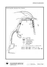
APPENDIX B (PLANNING MAPS)B05-01 WASTEWATER PURPOSES,WESTMERE PARKDevelopment to be in accordance with the following -1. All activities, works and buildings not fullydescribed in the notice of requirement shall be thesubject of either:(a) a new notice of requirement, which shall bepublicly notified, pursuant to <strong>Section</strong> 168 or 168Aof the Resource Management Act; or(b) a notice to alter the designation, pursuant to<strong>Section</strong> 181 of the Resource Management Act,which notice shall be publicly notified unless thealteration is minor and affected persons agree inaccordance with the provisions of <strong>Section</strong> 181(3)of the Act.2. Unless lapsed prior to 15 June 2010, the expiry dateof this designation was extended to 1 November2015, by S78 of the Local Government (<strong>Auckland</strong>Transitional Provisions) Act 2010.See also Diagram B05-01B05-01 Wastewater Purposes, Westmere ParkB06-03 PONSONBY PRIMARY SCHOOL,CURRAN STREETDevelopment to be in accordance with the following -1. The following trees shall not be cut, damaged,altered, injured, destroyed or partly destroyed otherthan in accordance with an outline plan submittedand processed in terms of <strong>Section</strong> 176A of theResource Management Act 1991:• indigenous trees (including the roots) over 6m inheight or with a girth (measured at 1.4m abovethe ground) greater than 600mm;• exotic trees (including the roots) over 8m inheight or with a girth (measured at 1.4m abovethe ground) greater than 800mm;• trees which are identified in the <strong>District</strong> <strong>Plan</strong> asscheduled trees as at 20 June 1995.In the case of a tree with multiple trunks (such aspohutukawa) the girth measurement shall be theaggregate or collective measurement of all trunkswhich have a circumference of 250mm or more.Provided that regular minor trimming ormaintenance effected by hand operated secateurs orpruning shears, may be undertaken in accordancewith accepted arboricultural practice, and thatremoval or trimming required to safeguard life andproperty is permitted without an outline plan.2. No works shall be carried out within the dripline ofthe following trees other than in accordance with anoutline plan submitted and processed in terms of<strong>Section</strong> 176A of the Resource Management Act1991:• indigenous trees (including the roots) over 6m inheight or with a girth (measured at 1.4m abovethe ground) greater than 600mm;• exotic trees (including the roots) over 8m inheight or with a girth (measured at 1.4m abovethe ground) greater than 800mm;• trees which are identified in the <strong>District</strong> <strong>Plan</strong> asscheduled trees as at 20 June 1995.In the case of a tree with multiple trunks (such aspohutukawa) the girth measurement shall be theaggregate or collective measurement of all trunkswhich have a circumference of 250mm or more.3. Carparking shall be provided at the rate of twocarparks per classroom, except where the <strong>Council</strong>accepts, on the basis of a specifically commissionedparking study by an appropriately qualified engineer,that a lesser level is appropriate.CITY OF AUCKLAND - DISTRICT PLANISTHMUS SECTION - OPERATIVE 1999 <strong>Section</strong> B1 - Page 1updated 28/10/2011
APPENDIX B (PLANNING MAPS)4. Unless lapsed prior to 15 June 2010, the expiry dateof this designation was extended to 1 November2015, by S78 of the Local Government (<strong>Auckland</strong>Transitional Provisions) Act 2010.B06-04 PACIFIC ISLAND EDUCATIONRESOURCE CENTRE, JERVOISROADDevelopment to be in accordance with the following -1. The following trees shall not be cut, damaged,altered, injured, destroyed or partly destroyed otherthan in accordance with an outline plan submittedand processed in terms of <strong>Section</strong> 176A of theResource Management Act 1991:• indigenous trees (including the roots) over 6m inheight or with a girth (measured at 1.4m abovethe ground) greater than 600mm;• exotic trees (including the roots) over 8m inheight or with a girth (measured at 1.4m abovethe ground) greater than 800mm;• trees which are identified in the <strong>District</strong> <strong>Plan</strong> asscheduled trees as at 20 June 1995.In the case of a tree with multiple trunks (such aspohutukawa) the girth measurement shall be theaggregate or collective measurement of all trunkswhich have a circumference of 250mm or more.Provided that regular minor trimming ormaintenance effected by hand operated secateurs orpruning shears, may be undertaken in accordancewith accepted arboricultural practice, and thatremoval or trimming required to safeguard life andproperty is permitted without an outline plan.2. No works shall be carried out within the dripline ofthe following trees other than in accordance with anoutline plan submitted and processed in terms of<strong>Section</strong> 176A of the Resource Management Act1991:• indigenous trees (including the roots) over 6m inheight or with a girth (measured at 1.4m abovethe ground) greater than 600mm;• exotic trees (including the roots) over 8m inheight or with a girth (measured at 1.4m abovethe ground) greater than 800mm;• trees which are identified in the <strong>District</strong> <strong>Plan</strong> asscheduled trees as at 20 June 1995.In the case of a tree with multiple trunks (such aspohutukawa) the girth measurement shall be theaggregate or collective measurement of all trunkswhich have a circumference of 250mm or more.3. Carparking shall be provided at the rate of twocarparks per classroom, except where the <strong>Council</strong>accepts, on the basis of a specifically commissionedparking study by an appropriately qualified engineer,that a lesser level is appropriate.4. No additions or alterations shall be made to thebuilding scheduled in the <strong>District</strong> <strong>Plan</strong> (MapReference B06-01, Pacific Island EducationResource Centre, formerly Bayfield Primary School)other than in accordance with an outline plansubmitted and processed in terms of <strong>Section</strong> 176A ofthe Resource Management Act 1991. This provisionshall not apply to the interior of the building but shallapply to the site surrounds as dimensioned in the<strong>Plan</strong>.5. Unless lapsed prior to 15 June 2010, the expiry dateof this designation was extended to 1 November2015, by S78 of the Local Government (<strong>Auckland</strong>Transitional Provisions) Act 2010.B06-05 BAYFIELD PRIMARY SCHOOL,JERVOIS ROADDevelopment to be in accordance with the following -1. The following trees shall not be cut, damaged,altered, injured, destroyed or partly destroyed otherthan in accordance with an outline plan submittedand processed in terms of <strong>Section</strong> 176A of theResource Management Act 1991:• indigenous trees (including the roots) over 6m inheight or with a girth (measured at 1.4m abovethe ground) greater than 600mm;• exotic trees (including the roots) over 8m inheight or with a girth (measured at 1.4m abovethe ground) greater than 800mm;• trees which are identified in the <strong>District</strong> <strong>Plan</strong> asscheduled trees as at 20 June 1995.In the case of a tree with multiple trunks (such aspohutukawa) the girth measurement shall be theaggregate or collective measurement of all trunkswhich have a circumference of 250mm or more.Provided that regular minor trimming ormaintenance effected by hand operated secateurs orpruning shears, may be undertaken in accordancewith accepted arboricultural practice, and thatremoval or trimming required to safeguard life andproperty is permitted without an outline plan.2. No works shall be carried out within the dripline ofthe following trees other than in accordance with anoutline plan submitted and processed in terms ofCITY OF AUCKLAND - DISTRICT PLAN<strong>Section</strong> B1 - Page 2 ISTHMUS SECTION - OPERATIVE 1999updated 28/10/2011
APPENDIX B (PLANNING MAPS)<strong>Section</strong> 176A of the Resource Management Act1991:• indigenous trees (including the roots) over 6m inheight or with a girth (measured at 1.4m abovethe ground) greater than 600mm;• exotic trees (including the roots) over 8m inheight or with a girth (measured at 1.4m abovethe ground) greater than 800mm;• trees which are identified in the <strong>District</strong> <strong>Plan</strong> asscheduled trees as at 20 June 1995.In the case of a tree with multiple trunks (such aspohutukawa) the girth measurement shall be theaggregate or collective measurement of all trunkswhich have a circumference of 250mm or more.3. Carparking shall be provided at the rate of twocarparks per classroom, except where the <strong>Council</strong>accepts, on the basis of a specifically commissionedparking study by an appropriately qualified engineer,that a lesser level is appropriate.4. Unless lapsed prior to 15 June 2010, the expiry dateof this designation was extended to 1 November2015, by S78 of the Local Government (<strong>Auckland</strong>Transitional Provisions) Act 2010.B06-07 PROPOSED ACCESSWAY, PARAWAICRESCENT / HECTOR STREETDevelopment will be a permitted activity provided that -1. Any works and activities shall be subject to theprovisions of the Coastal Management Area.2. The term for implementation of this designation shallbe within 12 years from the inclusion of thedesignation in the <strong>District</strong> <strong>Plan</strong> in accordance with<strong>Section</strong> 184 of the Resource Management Act 1991.3. Unless lapsed prior to 15 June 2010, the expiry dateof this designation was extended to 1 November2015, by S78 of the Local Government (<strong>Auckland</strong>Transitional Provisions) Act 2010.B06-10 CONCEPT PLAN - JERVOIS ROAD,HERNE BAYDOMINANT ACTIVITY: TAVERNPERMITTED ACTIVITIES• Retail premises• Tavern• Restaurants, cafes and other eating placesDEVELOPMENT CONTROLSAll development is subject to the development controlscontained in Clause 8.8.3 DEVELOPMENTCONTROLS FOR THE BUSINESS 8 ZONE of the<strong>Plan</strong>, except where otherwise specified.1. Building PlatformBuilding development is limited to the buildingplatform illustrated on the Concept <strong>Plan</strong>.2. Maximum Floor Area of Tavern Bar269m².3. ParkingA minimum number of 60 carparking spaces isrequired to be provided and maintained on site.Additional parking, in terms of the standards in Part12, will be required for any increase in gross floorarea. Adequate loading spaces in accordance withPart 12 must be provided and maintained on site.4. LandscapingThat part of the site not required for building,parking and vehicle manoeuvring must be plantedand maintained in trees and shrubs or otherwiselandscaped to the satisfaction of the <strong>Council</strong>.5. AccessNo reverse manoeuvring, of delivery vehicles to thesite, onto the adjoining roads shall occur.6. Building in Relation to BoundaryRule 8.8.3.5 BUILDING IN RELATION TOBOUNDARY shall not apply to buildings locatedwithin the building platform identified on theConcept <strong>Plan</strong>.7. Amenity BuffersRule 8.8.3.6 ACTIVITY BUFFERS shall not applyin areas where required landscaping is identified onthe Concept <strong>Plan</strong>ExplanationThe provisions for the site take into account the closeproximity of residentially zoned properties, and limitactivity on the site accordingly. Of particular concern isto ensure that adjoining residential properties areadequately screened and that landscaping is providedand maintained.B06-11 WASTEWATER PURPOSES,RESERVE END OF NOTTINGHAMSTREETDevelopment to be in accordance with the following -CITY OF AUCKLAND - DISTRICT PLANISTHMUS SECTION - OPERATIVE 1999 <strong>Section</strong> B1 - Page 3updated 28/10/2011
APPENDIX B (PLANNING MAPS)1. All activities, works and buildings not fullydescribed in the notice of requirement shall be thesubject of either:(a) a new notice of requirement, which shall bepublicly notified, pursuant to <strong>Section</strong> 168 or 168Aof the Resource Management Act; or(b) a notice to alter the designation, pursuant to<strong>Section</strong> 181 of the Resource Management Act,which notice shall be publicly notified unless thealteration is minor and affected persons agree inaccordance with the provisions of <strong>Section</strong> 181(3)of the Act.2. Unless lapsed prior to 15 June 2010, the expiry dateof this designation was extended to 1 November2015, by S78 of the Local Government (<strong>Auckland</strong>Transitional Provisions) Act 2010.See also Diagram B06-11B06-11 Wasterwater Purposes, Reserve Endof Nottingham Street (Coxs Bay Park)CITY OF AUCKLAND - DISTRICT PLAN<strong>Section</strong> B1 - Page 4 ISTHMUS SECTION - OPERATIVE 1999updated 28/10/2011
APPENDIX B (PLANNING MAPS)CITY OF AUCKLAND - DISTRICT PLANISTHMUS SECTION - OPERATIVE 1999 <strong>Section</strong> B1 - Page 5updated 28/10/2011
APPENDIX B (PLANNING MAPS)B06-33 CONCEPT PLAN- MARIST SCHOOLACTIVITIESPermitted Activities• Buildings used for recreational purposes• Care centres• Car parking areas• Community welfare facilities• Educational facilities• Organised sports and recreation, and associatedgrounds and playing fields• Places of Assembly• Residential accommodation associated with any ofthe above permitted activities• Community use of school facilities not otherwiseprovided for as a permitted activity in this Concept<strong>Plan</strong>Restricted Controlled Activities• The provision of on-site student pick up and drop offfacilitiesDiscretionary Activities• The provision of parking in areas not indicated on theconcept plan.DEVELOPMENT CONTROLSAll development is subject to the development controlscontained in Clause 10.8.1 ALL SITES SUBJECT TOCONCEPT PLANS IN THE SPECIAL PURPOSE 1AND 2 ZONES of the <strong>Plan</strong>, except where otherwisespecified below.Building LocationBuilding development is limited to the buildingplatforms illustrated on the Concept <strong>Plan</strong>.Provided that:1. Retaining walls and fences are permitted outside ofthe nominated building platforms subject tocompliance with all other controls in this Concept<strong>Plan</strong>.2. Covered walkways are permitted outside of thenominated building platforms subject to compliancewith all other controls in this Concept <strong>Plan</strong>.Building CoverageArea A -100%Area B-100%Area C-50%HeightArea A-9 metresArea B-8 metresArea C -8 metresProvided that a church spire may exceed the aboveheight limits by up to 8 metres.YardsNorthern boundary-8 metresSouthern boundary-8 metresWestern boundary-2 metresEastern boundary-nilProvided that:1. Retaining walls are permitted to a maximum heightof 2 metres within the southern yard provided theretaining walls are at least 4 metres from theboundary.2. Fencing required under the Building Act or anybylaws or regulations to be placed above a retainingwall within the southern yard, or provided to reducenoise transmission or headlight spill from parkingareas, is permitted to a maximum height of 1.5metres above the retaining wall.LandscapingThe Required Landscaping areas shown on the Concept<strong>Plan</strong> shall be densely planted with trees and shrubssufficient to provide a screen during all seasons of theyear.For the northern boundary, the particular species shouldbe selected to provide screening to a height of at least 3metres at maturity.For the southern and western boundaries, the particularspecies should be selected to provide screening to aheight of between 2 metres and 5 metres at maturity.Species that typically grow to a height greater than 5metres should be avoided.Vehicle AccessPrior to the occupation of any new development that willincrease the school roll above 200 or the size of thechurch auditorium:1. The major access/egress shown on the Concept <strong>Plan</strong>shall be widened to provide two-way access to thecarpark in front of the church; and2. In the case of an increase in the school roll, provisionshall be made for safe and efficient on-site studentpick-up and drop off.CITY OF AUCKLAND - DISTRICT PLAN<strong>Section</strong> B1 - Page 6 ISTHMUS SECTION - OPERATIVE 1999updated 28/10/2011
APPENDIX B (PLANNING MAPS)ParkingParking shall be provided in accordance with therequirements of Part 12 of the <strong>District</strong> <strong>Plan</strong>.Land Subject to InstabilityResource consent is not required under Rule 5D.6.1 ofthe <strong>District</strong> <strong>Plan</strong> where works are undertaken inaccordance with the recommendations, and under thesupervision, of a registered engineer.Where resource consent is required for other matters, thecouncil may impose a condition requiring thesubmission of a geotechnical report with the buildingconsent application.CRITERIA FOR ASSESSING RESTRICTEDDISCRETIONARY ACTIVITIESThe <strong>Council</strong> will seek to ensure that:• Headlight spill to adjoining residential properties isminimised;• The visual impact from adjoining residentialproperties is minimised;• The transmission of vehicle noise to adjoiningresidential properties is minimised;• The layout of the vehicle access and parking areasprovides for safe and efficient circulation and pickupand drop-off of students.The <strong>Council</strong> may impose conditions in relation to thefollowing matters:• The provision of visual and/or acoustic screeningbetween parking areas and adjoining residentialproperties (any screening will apply in lieu of thescreening requirement in Part 12 of the <strong>District</strong> <strong>Plan</strong>).• The layout of vehicle access and parking areas.ExplanationThe Marist School site performs an important communityfunction in addition to its education function.The School grounds include a church which is regularlyused by both the School and by a congregationindependent of the School.The grounds also include a former convent, which hasbeen used for a wide range of activities in the past,including parish administration, education andcommunity welfare services.The Concept <strong>Plan</strong> provides for a continuation of theseactivities and an expansion of the School roll, throughfurther development, subject to controls over the locationand scale of that development, the provision of additionalparking and the provision of improved access and pickupand drop-off facilities.The School is within a mainly residential area, directlyadjoining residential properties to the north, south, andpart of the western boundaries. The residential area tothe north is recognised as a special character area. Thelocation and scale of development permitted under theConcept <strong>Plan</strong> site has been defined to minimise thepotential for impact on the special character of that area.The residential area to the south sits below the Schoolsite. Accordingly, the Concept <strong>Plan</strong> requires asignificant buffer along the southern boundary, tominimise the potential for visual domination.The School adjoins St Paul's College to the east. StPaul's College has a Special Purpose 2 zoning, the sameas that applying to the School.B07-16 ROYAL NZ NAVY VOLUNTEERRESERVE HEADQUARTERS, STMARYS BAYDevelopment to be in accordance with the following -1. The Maori heritage site (Ko Takerehaea) which isscheduled in the <strong>District</strong> <strong>Plan</strong> shall not be excavated,physically investigated, damaged, or altered otherthan in accordance with an outline plan of workssubmitted and processed in terms of <strong>Section</strong> 176A ofthe Resource Management Act 1991.2. Unless lapsed prior to 15 June 2010, the expiry dateof this designation was extended to 1 November2015, by S78 of the Local Government (<strong>Auckland</strong>Transitional Provisions) Act 2010.B07-19 FREEMANS BAY PRIMARY SCHOOL,WELLINGTON STREETDevelopment to be in accordance with the following -1. The following trees shall not be cut, damaged,altered, injured, destroyed or partly destroyed otherthan in accordance with an outline plan submittedand processed in terms of <strong>Section</strong> 176A of theResource Management Act 1991:• indigenous trees (including the roots) over 6m inheight or with a girth (measured at 1.4m above theground) greater than 600mm;• exotic trees (including the roots) over 8m in heightor with a girth (measured at 1.4m above theground) greater than 800mm;• trees which are identified in the <strong>District</strong> <strong>Plan</strong> asscheduled trees as at 20 June 1995.In the case of a tree with multiple trunks (such aspohutukawa) the girth measurement shall be theaggregate or collective measurement of all trunksCITY OF AUCKLAND - DISTRICT PLANISTHMUS SECTION - OPERATIVE 1999 <strong>Section</strong> B1 - Page 7updated 28/10/2011
APPENDIX B (PLANNING MAPS)PART 5B - COASTAL;PART 5C - HERITAGE; andPART 13 - INTERPRETATIONS ANDDEFINITIONS.2. The term for implementation of this designation shallbe within 12 years from the inclusion of thedesignation in the <strong>District</strong> <strong>Plan</strong> in accordance with<strong>Section</strong> 184 of the Resource Management Act.3. Unless lapsed prior to 15 June 2010, the expiry dateof this designation was extended to 1 November2015, by S78 of the Local Government (<strong>Auckland</strong>Transitional Provisions) Act 2010.B07-30 COUNCIL CARPARK ANDPROPOSED RESERVE, DEDWOODTERRACEDevelopment to be in accordance with the following -1. All activities, works and buildings not fullydescribed in the notice of requirement shall be thesubject of either:(a) a new notice of requirement, which shall bepublicly notified, pursuant to <strong>Section</strong> 168A of theResource Management Act; or(b) a notice to alter the designation, pursuant to<strong>Section</strong> 181 of the Resource Management Act,which notice shall be publicly notified unless thealteration is minor and the affected persons agreein accordance with the provisions of <strong>Section</strong>181(3) of the Act.2. Unless lapsed prior to 15 June 2010, the expiry dateof this designation was extended to 1 November2015, by S78 of the Local Government (<strong>Auckland</strong>Transitional Provisions) Act 2010.B07-31 COUNCIL CARPARK, REDMONDSTREETDevelopment to be in accordance with the following -1. All activities, works and buildings not fullydescribed in the notice of requirement shall be thesubject of either:(a) a new notice of requirement, which shall bepublicly notified, pursuant to <strong>Section</strong> 168A of theResource Management Act; or(b) a notice to alter the designation, pursuant to<strong>Section</strong> 181 of the Resource Management Act,which notice shall be publicly notified unless thealteration is minor and the affected persons agreein accordance with the provisions of <strong>Section</strong>181(3) of the Act.2. Unless lapsed prior to 15 June 2010, the expiry dateof this designation was extended to 1 November2015, by S78 of the Local Government (<strong>Auckland</strong>Transitional Provisions) Act 2010.B07-32 COUNCIL CARPARK, MARGARETSTREETDevelopment to be in accordance with the following -1. All activities, works and buildings not fullydescribed in the notice of requirement shall be thesubject of either:(a) a new notice of requirement, which shall bepublicly notified pursuant to <strong>Section</strong> 168A of theResource Management Act; or(b) a notice to alter the designation, pursuant to<strong>Section</strong> 181 of the Resource Management Act,which notice shall be publicly notified unless thealteration is minor and the affected persons agreein accordance with the provisions of <strong>Section</strong>181(3) of the Act.2. Unless lapsed prior to 15 June 2010, the expiry dateof this designation was extended to 1 November2015, by S78 of the Local Government (<strong>Auckland</strong>Transitional Provisions) Act 2010.B07-33 COUNCIL CARPARK, POMPALLIERTERRACEDevelopment to be in accordance with the following -1. All activities, works and buildings not fullydescribed in the notice of requirement shall be thesubject of either:(a) a new notice of requirement, which shall bepublicly notified, pursuant to <strong>Section</strong> 168A of theResource Management Act, or(b) a notice to alter the designation, pursuant to<strong>Section</strong> 181 of the Resource Management Act,which notice shall be publicly notified unless thealteration is minor and the affected persons agreein accordance with the provisions of <strong>Section</strong>181(3) of the Act.2. Unless lapsed prior to 15 June 2010, the expiry dateof this designation was extended to 1 November2015, by S78 of the Local Government (<strong>Auckland</strong>Transitional Provisions) Act 2010.CITY OF AUCKLAND - DISTRICT PLANISTHMUS SECTION - OPERATIVE 1999 <strong>Section</strong> B1 - Page 9updated 28/10/2011
APPENDIX B (PLANNING MAPS)B07-34 COUNCIL CARPARK, ENGLANDSTREETDevelopment to be in accordance with the following -1. All activities, works and buildings not fullydescribed in the notice of requirement shall be thesubject of either:(a) a new notice of requirement, which shall bepublicly notified, pursuant to <strong>Section</strong> 168A of theResource Management Act, or(b) a notice to alter the designation, pursuant to<strong>Section</strong> 181 of the Resource Management Act,which notice shall be publicly notified unless thealteration is minor and the affected persons agreein accordance with the provisions of <strong>Section</strong>181(3) of the Act.2. Unless lapsed prior to 15 June 2010, the expiry dateof this designation was extended to 1 November2015, by S78 of the Local Government (<strong>Auckland</strong>Transitional Provisions) Act 2010.B07-49 PONSONBY INTERMEDIATESCHOOLDevelopment to be in accordance with the following -1. The following trees shall not be cut, damaged, altered,injured, destroyed or partly destroyed other than inaccordance with an outline plan submitted andprocessed in terms of <strong>Section</strong> 176A of the ResourceManagement Act 1991:• indigenous trees (including the roots) over 6m inheight or with a girth (measured at 1.4m above theground) greater than 600mm;• exotic trees (including the roots) over 8m in heightor with a girth (measured at 1.4m above theground) greater than 800mm.In the case of a tree with multiple trunks (such aspohutukawa) the girth measurement shall be theaggregate or collective measurement of all trunkswhich have a circumference of 250mm or more.Provided that regular minor trimming or maintenanceeffected by hand operated secateurs or pruning shears,may be undertaken in accordance with acceptedarboricultural practice, and that removal or trimmingrequired to safeguard life and property is permittedwithout an outline plan.2. No works shall be carried out within the dripline ofthe following trees other than in accordance with anoutline plan submitted and processed in terms of<strong>Section</strong> 176A of the Resource Management Act 1991:• indigenous trees (including the roots) over 6m inheight or with a girth (measured at 1.4m above theground) greater than 600mm;• exotic trees (including the roots) over 8m in heightor with a girth (measured at 1.4m above theground) greater than 800mm.In the case of a tree with multiple trunks (such aspohutukawa) the girth measurement shall be theaggregate or collective measurement of all trunkswhich have a circumference of 250mm or more.3. Carparking shall be provided at the rate of twocarparks per classroom, except where the <strong>Council</strong>accepts, on the basis of a specifically commissionedparking study by an appropriately qualified engineer,that a lesser level is appropriate.B07-88 PONSONBY CENTRE PLANIntroductionThe Ponsonby/Jervois Roads’ ridge area is a mixed usearea with residential, commercial, retail and entertainmentactivities. It is particularly well known for its mixedheritage built environment. The history of the area andbuilt character is described in detail in the Ponsonby andJervois Roads Heritage Study, Volume I, and StreetscapeStudy, Volume II. The Centre <strong>Plan</strong> is aimed at conserving,reinforcing and promoting the environmental quality, theheritage amenity and vitality of the Ponsonby/JervoisRoads’ ridge precinct.The Centre <strong>Plan</strong> identifies the particular factors whichgive the ridge its unique character. It proposes certainmeasures which are designed to maintain and enhance itscharacter; it promotes the amenity of the centre andindicates the future implementation of streetscapeimprovements as proposed and promoted by PonsonbyMainstreet.The provisions of the Centre <strong>Plan</strong> are in addition to or insome cases override the standard controls for therespective zones which would otherwise apply in the<strong>District</strong> <strong>Plan</strong>.Attributes of the CentreA. Design and CharacterThe Ponsonby/Jervois Road ridge contains a number ofheritage items which are scheduled in the <strong>District</strong> <strong>Plan</strong>. Italso contains a great number of other buildings andgroups of buildings which are not scheduled, but are ofhistoric and community value, and contribute to the area’sspecial character and amenity values. These buildings aregenerally grouped together on adjoining sites and displaysimilar building forms and architectural details. The ridgeCITY OF AUCKLAND - DISTRICT PLAN<strong>Section</strong> B1 - Page 10 ISTHMUS SECTION - OPERATIVE 1999updated 28/10/2011
APPENDIX B (PLANNING MAPS)is united historically and aesthetically by form andphysical character. The special character created by theexisting scale and nature of development highlights theorigins of the area which are an important link with thepast and are worth preserving. However, the consistencyof the historic character varies along the ridge.The buildings along Ponsonby Road ridge represent allperiods from the Victorian era to the present day. The areacontains a number of key landmark buildings from theVictorian and Edwardian eras, such as the Ponsonby PostOffice, Leys Institute, and the former Newton PoliceStation and St Johns Church. A number of Victorian andEdwardian commercial / residential buildings, oftengrouped in rows or around major intersections, are alsoconsidered character defining elements. These buildingsmaintain a strong visual presence due to their height,visual rhythms and distinctive detailing. There are also anumber of buildings from the inter-war period.While there is an eclectic mix of buildings from differenteras, the contribution individual buildings make todistinctive groups is a very important feature of the area.These groups of buildings often occur aroundintersections and nodes, which give different parts of thestrip a varying character, and contribute to the variety ofbuilt character that is an important feature of the area.The varying character and mix of buildings has dictated aregime of controls which recognises this. Considerationhas also been given to the fact that some groups ofbuildings have been subjected to more alteration, and thatsome individual buildings are unremarkable. This has ledto identification of Conservation Areas where change tobuilt character is seen as less desirable, and also atransition zone / buffer area around the ConservationAreas, where there is more flexibility, and the emphasisis on controlling activities which will impact on thenearby Conservation Areas.Two types of area have been identified along the ridge asdiscussed above. These are identified in the Centre <strong>Plan</strong>as: Conservation Areas and Conservation InterfaceAreas.The Conservation Areas contain buildings which byvirtue of their individual or group characteristics warranta higher level of protection. The Conservation InterfaceAreas are subject to provisions which seek to preserveand enhance this character and include general provisionswhich protect these features.Clause 5C.7.2 CONSERVATION AREAS of the <strong>District</strong><strong>Plan</strong> includes objectives, policies and strategies relatingto Conservation Areas.B. Traffic System and ParkingPonsonby and Jervois Roads are strategically locatedbetween the Central Area and the western suburbs.Ponsonby and Jervois Roads are both regional arterialroutes. The level of traffic movements which occur onthese roads has created conflicts between local andthrough traffic within the area.Ponsonby has evolved as a well known restaurant andentertainment centre. Much of Ponsonby was developedat a time before the motor car was widely in use. Veryfew of the older residential or commercial sites in thearea have sufficient off street parking to deal with thelevel of parking generated by existing activities. This hasresulted in a parking shortfall on Ponsonby and JervoisRoads. This is taken up to some extent in the adjoiningresidential side streets - particularly at peak hours.C. ActivitiesThe area covered by this Centre <strong>Plan</strong> is set out in theattached map and includes land zoned Business 2 and 4.These zones are applied to existing suburban retail andcommercial centres outside the Central Area. Withinthese zones a range of intensity of activity, including lightindustrial and services in the Business 4 zone is providedfor. The activity rules for the Business 2 and 4 zonesapply within the Centre <strong>Plan</strong>.D. Development ControlsThe development controls set out in the Centre <strong>Plan</strong> arein addition to the development controls applied under theBusiness 2 and 4 zones in the <strong>District</strong> <strong>Plan</strong> and areintended over time to achieve the results outlined in theintroduction.E. DesignationsThe Centre <strong>Plan</strong> also identifies areas where the <strong>Council</strong> isresponsible for public works. These are in the form of<strong>Council</strong> owned carparks, and in the form of land subjectto requirements for road widening or service lanes.Known as ‘designations’ these are listed in <strong>Appendix</strong> Aand <strong>Appendix</strong> B of the <strong>District</strong> <strong>Plan</strong> Maps. In the case ofproposed designations, the Resource Management Act1991 sets out the procedures relating to land subject todesignations.F. Scheduled ItemsThe Ponsonby/Jervois Roads’ ridge contains a number ofscheduled buildings and scheduled trees. These items areindicated on the <strong>District</strong> <strong>Plan</strong> Maps and are detailed inAppendices 1 and 2 to the <strong>District</strong> <strong>Plan</strong> Text. These itemsare subject to the rules outlined in PART 5C -HERITAGE of the <strong>Plan</strong> which override rules containedin the Centre <strong>Plan</strong>.DEVELOPMENT CONTROLS1.0 CONSERVATION AREA CONTROLSThese controls apply to sites identified in theCentre <strong>Plan</strong> as being in Conservation Areas, being-CITY OF AUCKLAND - DISTRICT PLANISTHMUS SECTION - OPERATIVE 1999 <strong>Section</strong> B1 - Page 11updated 28/10/2011
APPENDIX B (PLANNING MAPS)a) Scheduled buildings, objects, heritageproperties, places or notable treesAny scheduled building, object, place,heritage property or tree located in theConservation Area is required to comply withthe provisions of Clauses 5C.7.1BUILDINGS, OBJECTS, HERITAGEPROPERTIES AND PLACES OF SPECIALVALUE and 5C.7.3 TREES of the <strong>Plan</strong>. Thoseprovisions take precedence over the provisionsfor Conservation Areas.b) Demolition, removal, alterations oradditions to any non-scheduled building orfeature or construction of any new buildingNo person shall, without a resource consentfor restricted discretionary activity, destroy,remove, alter or damage any building, orfeature, except that this provision shall notpreclude:i) the redecoration, repair and/or minoralteration of any existing fabric or detailingcarried out in a manner and design, andwith similar materials to those originallyused which does not detract from thosefeatures for which the Conservation Areahas been identified;ii) redecoration, repair or alterations whichare internal;iii) any change of activity otherwise permittedon the sites which is unrelated to thepurpose for which the Conservation Areawas identified, and which does not detractfrom the significant features of theConservation Area.1.1 Criteria for Assessing Applications forResource ConsentThe <strong>Council</strong> will consider as a restricteddiscretionary activity (refer PART 4 - GENERALPROVISIONS AND PROCEDURES of the<strong>District</strong> <strong>Plan</strong>) any application to demolish,construct a building, or make alterations oradditions to any building or feature, includingany works in the street environment, within aConservation Area.1.2 General Assessment CriteriaIn considering an application the <strong>Council</strong> willhave regard to the provisions of Part 4 and thefollowing matters -1. The nature, form and extent of thedevelopment, alteration or change and itseffect on the particular character of theConservation Area. Particular characteristicsare described in the Ponsonby and JervoisRoad Heritage Study, Volume II (streetscapestudy).2. Evidence presented by the applicant in supportof their application.3. Provisions of the ICOMOS NZ Charter whereappropriate (refer APPENDIX 4 of the <strong>District</strong><strong>Plan</strong>).4. Demonstration that any demolition or removalof a building will not significantly affect thestreetscape appearance of the ConservationArea and will not destroy the ConservationArea’s historic character.1.3 Assessment Criteria for Specific Activities1. External additions or alterations to existingbuildingsIt is the intent of these criteria that additionsor alterations to existing structures in theseareas are designed and located in a mannerwhich faithfully respects (and where feasiblereplicates) the surviving original physical andarchitectural character, proportion and designof the area. Restoration, where appropriate,should be faithful to original known states,and new elements should be designed,proportioned and detailed so as to not beimmediately or obtrusively obvious.When assessing an application for a resourceconsent for building additions or alterations,the <strong>Council</strong> shall have regard to the following -a) additions or alterations to the streetelevation of the building shall be avoidedunless they maintain an appearancegenerally similar to the original.b) subject to the above, additions shall be sopositioned or modifications so designed, asnot to detract from the continuity of frontfacade alignment of the subject building.c) any external addition or alterations shall becarried out in a manner and of a design andmaterials similar to those originally usedwhich do not detract from the architecturalcharacter and detailing of the building.d) as much of the existing building fabric aspracticable shall be retained byrefurbishing, restoring and adapting partsof the existing building rather thanreplacing them.e) alterations and additions shall be inkeeping with the architectural and historicCITY OF AUCKLAND - DISTRICT PLAN<strong>Section</strong> B1 - Page 12 ISTHMUS SECTION - OPERATIVE 1999updated 28/10/2011
APPENDIX B (PLANNING MAPS)form, proportions and style of the existingbuilding on the site.f) unpainted masonry and plaster detailingand finishes shall be retained unpainted asoriginal.g) the use of unsympathetic material shall beavoided, such as aluminium window ordoor frames and the use of plaster ormasonry finishes or brick or block workwhere timber was original.h) the colour scheme of buildings shall becompatible with the age and detailing ofthe building, and preferably derived fromresearch into the original colour scheme ofthe building.2. Construction or relocation of any buildingor structure or accessory buildingIt is the intent of these criteria that newbuildings or structures are designed, locatedand finished so as to be strongly empatheticand coherent with the original stylepredominant in the area, regardless ofwhether the construction and detail of the newitem is faithful to its own time or is anaccurate replica of the original style.When assessing an application for a resourceconsent for construction of a new building orrelocation of a building, the <strong>Council</strong> must besatisfied that -a) the form, mass, proportion and materialsand detailing of the building shall beempathetic with the original architecturalstyle predominant in the immediatevicinity of the subject site (on thePonsonby/Jervois Roads ridge).b) on the street facing facade, horizontal andvertical modulation, fenestration, andfacade height proportions and detailingshall be compatible with the originalarchitectural style predominant in theimmediate vicinity of the subject site.c) the building shall be positioned so as not todetract from the continuity of front facadealignment of buildings in the vicinity.d) any building on a corner site shall bedesigned to be compatible with othercorner buildings at the same intersection.e) the colour scheme of new buildings shallnot detract from the overall character of theConservation area.The Karangahape Road guidelines(incorporated in Volume 2 of the Central Area<strong>Section</strong> of the <strong>District</strong> <strong>Plan</strong>) graphicallyillustrate the issues referred to in the criteria.These guidelines are a performance standardthat indicates appropriate solutions foralterations to existing buildings and newbuildings in a precent of buildings similar toparts of Ponsonby Road.ExplanationThe Centre <strong>Plan</strong> identifies certain areas as beingworthy of specific controls. These ConservationAreas are applied to specific sites or groups ofbuildings within the area. The intention of theConservation Area provisions is to maintain theunique authenticity of character of each area.The environment in the Conservation Areas is onewhere the built environment predominates and isfinely articulated. The primary purpose of theConservation Areas is to preserve the uniquecharacter and fabric of the area. It is expectedthat over time, areas subject to the ConservationArea overlay provisions will display a uniquecharacter representing a particular era of<strong>Auckland</strong>’s heritage. Activities which do notadversely affect this character are provided for inthese areas, as will new buildings and additionscomplementary and in keeping with the character.2.0 CONSERVATION INTERFACE AREACONTROLSThis control applies to sites identified in theCentre <strong>Plan</strong> as being in the ConservationInterface Areas.No person shall, without a resource consent forrestricted controlled activity, destroy, remove,alter or damage any building, except that thisprovision shall not preclude:a) the redecoration, repair and/or minoralteration of any existing fabric or detailingcarried out in a manner and design, and withsimilar materials to those originally usedwhich does not detract from the appearanceand character of the building concerned;b) redecoration, repair or alterations which areinternal;c) any change of activity which is otherwisepermitted on the sites which is unrelated to thepurpose for which the Conservation InterfaceArea was identified and which does not detractfrom the built character of the ConservationInterface Area.CITY OF AUCKLAND - DISTRICT PLANISTHMUS SECTION - OPERATIVE 1999 <strong>Section</strong> B1 - Page 13updated 28/10/2011
APPENDIX B (PLANNING MAPS)2.1 Criteria for Assessing Applications forResource ConsentThe <strong>Council</strong> will consider as a restrictedcontrolled activity (refer PART 4 - GENERALPROVISIONS AND PROCEDURES of the<strong>District</strong> <strong>Plan</strong>) any application to demolish,construct a building, or make alterations oradditions to any building or feature, includingany works in the street environment, within aConservation Interface Area. In assessingapplications the <strong>Council</strong> will consider evidencepresented by the applicant in support of theirapplication.2.2 Assessment Criteria for Specific Activities.1. External additions or alterations to existingbuildingsWhen assessing an application for a resourceconsent for building additions or alterations,the <strong>Council</strong> must be satisfied that:a) Changes to the road facade of the buildingshall be empathetic with the existingsubject building and other buildings withinthe Conservation Interface Area;b) Subject to the above, additions shall be sopositioned or modifications so designed asnot to detract from the continuity of frontfacade alignment of the adjoiningbuildings;c) The form, mass, proportion and materialsof the addition or alteration shall becompatible with the prevailingarchitectural style of the existing buildingon the site;d) Materials and the use of materials shall bein sympathy with the traditional characterand material of buildings in the vicinity;e) The colour of buildings in theConservation Interface Area shall becompatible with the character andappearance of the adjacent ConservationArea, and not detract from or dominate thecharacter of the area.2. Criteria for the construction of newbuildings or relocation of existing buildingsWhen assessing an application for a resourceconsent for a new building, the <strong>Council</strong> mustbe satisfied that:a) The form, mass, proportion and materialsof the building shall be empathetic with theoriginal architectural style predominant inthe vicinity and shall not ignore, competewith, or dominate that character. This shallnot limit the size of developments whichcomply with the development controlsproviding an empathy with existingdevelopment is achieved;b) The building shall be so positioned as notto detract from the continuity of the frontfacade alignment of adjoining buildings;c) Vertical and horizontal modulation of thefront facade, fenestration and verandahdesign and detailing shall be compatiblewith buildings in adjacent ConservationAreas, forming a transition betweenConservation Areas and nearby areaswhere design and appearance controls donot apply;d) Buildings on corner sites shall becompatible with original corner buildingsat the same intersections, and whileresponding to the prominence andtraditional use of corner sites, not undulydominate the existing character of the area.Rule 8.8.1.3C of the <strong>Plan</strong> will not apply toany building which is built to the streetboundary;e) The colour of buildings in the transitionalzone shall be compatible with the characterand appearance of the precinct, and notdetract from or dominate the character ofthe area, particularly when adjacent to aConservation Area.ExplanationIt is acknowledged that not all the buildings andsites on the Ponsonby/Jervois Road ridge are ofthe quality of the buildings within theConservation Areas. However, anyredevelopment of these buildings or the sites theyoccupy has the potential to have adverse effects onadjacent Conservation Areas. Buildingdevelopment is a controlled activity. Developmentin the Conservation Interface Areas is limited tothe extent that it will not detract from the adjacentConservation Areas.Also, it is expected that over time, local amenityvalues will be enhanced. In some areas this willoccur to the extent that these areas may becomethe Conservation Areas of the future.3.0 VERANDAH CONTROLThis control applies to sites identified in theCentre <strong>Plan</strong>. A resource consent for a restrictedcontrolled activity is required for any workinvolving a verandah in this area.CITY OF AUCKLAND - DISTRICT PLAN<strong>Section</strong> B1 - Page 14 ISTHMUS SECTION - OPERATIVE 1999updated 28/10/2011
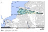
APPENDIX B (PLANNING MAPS)B07-88 Ponsonby Centre <strong>Plan</strong>JERVOIS ROADPROSFORD STREETBLAKE STREETSHEEHAN STREETSEYMOUR STREETREDMOND STREETDEDWOOD TERRACEMARGARET STREETST MARYS ROADDUBLIN STREETGREEN STREETCOLLEGE HILLNEW STREETHARGREAVES STREETBEAUMONT STREETNSOUTHERN MOTORWAYVICTORIA STREET WESTPOMPALLIER TERRACECOWAN STREETRENALL STREETRUSSELL STREETGEORGINA STREETCOSTLEY STREETRUNNELL STREETSPRING STREETSCOTLAND STREETWELD STREETUNION STREETPONSONBY ROADMIDDLE STREETCLARENCE STREETPONSONBY TERRACETOLE STREETO'NEILL STREETARTHUR STREETWOOD STREETPEMBER REEVES STREETELIZABETH STREETRYLE STREETENGLAND STREETGUNSON STREETIRELAND STREETFRANKLIN ROADSHERIDAN LANENAPIER STREETSUMMER STREETPRATT STREETWELLINGTON STREETSTUART STREETHOWE STREETVERMONT STREETCOLLINGWOOD STREETPONSONBY ROADBERESFORD STREET WESTLINCOLN STREETANGLESEA STREETNORFOLK STREETDOUGLAS STREETPAGET STREETWINN ROADMIRA STREETPICTON STREETHEPBURN STREETTAHUNA STREETKENT STREETBROWN STREETBARRIE STREETRICHMOND ROADSUSSEX STREETLEIGHTON STREETSCANLAN STREETPONSONBY ROADMILLAIS STREETROSE ROADHOPETOUN STREETMAHON WAYDICKENS STREETJULIAN STREETMURDOCH ROADArea included inPonsonby Centre <strong>Plan</strong>Conservation Interface AreaConservation AreaWILLIAMSON AVENUEMACKELVIE STREETCRUMMER ROADPOLLEN STREETMAIDSTONE STREETGREAT NORTH ROADKARANGAHAPE ROADNEWTON ROADGUNDRY STREETOPHIR STREETCITY OF AUCKLAND - DISTRICT PLANISTHMUS SECTION - OPERATIVE 1999 <strong>Section</strong> B1 - Page 15updated 28/10/2011
APPENDIX B (PLANNING MAPS)3.1 Criteria for Assessing Applications forResource Consent1. A verandah shall be provided along the fullextent of any frontage on Ponsonby andJervois Roads and on corner sites. Theverandah shall be related to its neighbours insuch a way that it ensures continuouspedestrian cover. The only exception to thiscontrol is where buildings are listed in<strong>Appendix</strong> 1 of the <strong>Plan</strong>. In these instances theconstruction of a verandah has the potential toalter the historic character of the building andmay not therefore be required.2. The minimum height of the verandah is 3.0metres above the footpath immediately belowand the maximum height is 4.0 metres. Thismay be varied if the existing verandahs of theimmediate neighbours do not fall inside theseparameters. Unless there are uniquecircumstances, the verandah shall be the sameheight as its neighbours.3. The verandah shall be set no further than 600mm from the kerbline and, unless there areunique circumstances, will have frontageparallel with its neighbours.4. The design of the verandah and lighting willbe assessed as part of the resource consent todetermine its compatibility with the historiccharacter of the subject building andsurrounding buildings.ExplanationThis control is intended to ensure that pedestriansvisiting the centre are protected from theconstantly changing nature of <strong>Auckland</strong>’sclimate. It is also anticipated that the verandahswill contribute to the character of the streetscapein the centre. The lighting requirements areintended to both help and encourage pedestriansto use the centre at night, as verandahs can reducethe amount of lighting available from street lights.Alternative options to providing lighting inverandahs may be considered if the intendedeffect of lighting the footpath for pedestrians canbe assured.4.0 VEHICLE CROSSING RESTRICTIONSWhere vehicular access to a site for parking andloading is available by way of rear service lanesor right of ways, or from side roads not subject tovehicular crossing restrictions, no vehiclecrossing shall be permitted to sites as shown onthe Centre <strong>Plan</strong> with frontage to Ponsonby Roador Jervois Road.ExplanationAs a consequence of the potential for vehiclecrossings to interfere with the movement ofpedestrians along the main arterial retail area ofthe centre, vehicle crossing is prohibited alongfrontages with a high level of pedestrian activity.Street improvements undertaken to date haveintroduced a high level of pedestrian amenity.This amenity would be compromised by theintroduction of additional vehicle movements.5.0 PARKING1. Exemption for buildings in conservationareas and for scheduled buildingsProperties in the Conservation Areas andbuildings scheduled in <strong>Appendix</strong> 1 of the <strong>Plan</strong>are entitled to a reduction of required parkingof up to a maximum of 10 spaces. Thisexemption shall apply when the activities inexisting buildings change or when theadaptive reuse of these buildings occurswhich would require additional parking inClause 12.8.1 PARKING of the <strong>Plan</strong>.This exemption does not apply toredevelopment of these sites which includesthe removal and/or replacement of existingbuildings. Nor does the exemption apply toany additional floor area which is added tobuildings in the Conservation Areas or anyextension or alteration of the existing buildingwhich will result in a change to the footprintof the building. This form of developmentwill be expected to comply fully with requiredoff-street parking.An annual review of the effects of theexemption provisions will take place from thedate of the exemption having effect. Thisreview will determine the level of effect theexemption is having on the area and if thepolicy relating to exemptions should continueto be operated.2. Bulk parkingWherever possible the <strong>Council</strong> will encouragethe use of bulk parking for activities whichseek to establish in the area and cannotprovide all required parking on site. This caneither be in the form of multiple use ofparking spaces by activities which havedifferent hours of operation. Alternatively thiscould be achieved by development of parkingto serve multiple sites as an alternative to theprovision of parking for separate individualsites.CITY OF AUCKLAND - DISTRICT PLAN<strong>Section</strong> B1 - Page 16 ISTHMUS SECTION - OPERATIVE 1999updated 28/10/2011
APPENDIX B (PLANNING MAPS)3. Location of parking and loadingOn sites covered by the Centre <strong>Plan</strong> the<strong>Council</strong> will not permit the use of the areasbetween buildings existing as at 1 December1997 and the road boundary as a location forany parking or loading spaces.Within the area affected by the Centre <strong>Plan</strong>,parking and loading shall be to the rear of thesites. These parking areas will generally beaccessed from service lanes or right of waysor from roads not subject to the vehicularcrossing restrictions, except where this is notpossible because the only available access isfrom Ponsonby or Jervois Roads.ExplanationThe <strong>Council</strong> recognises that the provision ofrequired parking can be to the detriment of older,heritage buildings which currently have little orno available off-street parking. The main priorityin the Ponsonby/Jervois Roads ridge is thepreservation and enhancement of its heritagecharacter. Exemptions for off-street parking areconsidered appropriate to encourage theretention of scheduled buildings and buildings inthe Conservation Areas while allowing change ofactivity and adaptive reuse. These exemptions arenot available for removal and replacement ofscheduled buildings or buildings in theConservation Areas.The <strong>Council</strong> also recognises that because of theage and style of development in Ponsonby therewill inevitably be a shortfall of parking in thearea. Additional parking can most efficiently beprovided for a number of sites and activitiescomprehensively at one location where accessand manoeuvring areas can be provided, ratherthan sporadically on a number of sites.To encourage the retention of existing buildingsat the street frontage provision of new parkingareas will be to the rear of sites. These willgenerally be accessed from service lanes, rightsof ways and side roads. Where this is not possibleaccess to the rear of sites may be gained fromPonsonby or Jervois Roads.6.0 SIGNSAll proposals for signs on buildings or attached tobuildings or as free standing structures within thearea affected by the Centre <strong>Plan</strong> shall require arestricted discretionary activity resource consent(refer PART 4 - GENERAL PROVISIONS ANDPROCEDURES).The entire area covered by the Ponsonby Centre<strong>Plan</strong> is a special character area for the purpose ofadministration of the Signs Bylaw.6.1 Criteria for Assessing Applications forResource ConsentAll applications for resource consent shallcomply with the Signs Bylaw and the followingassessment criteria shall be used to assessapplications -1. Signage in the Conservation Interface Areashall be of a scale and design that does notdominate the adjacent Conservation Areas.2. Signage on any building shall be designed asan integral part of the building, and notobscure architectural detail or windows.3. Signage shall not visually dominate any part ofa building, including any wall.4. Signage shall be compatible with the originalarchitectural style of any building on which itis placed.5. Product advertising should only be included asa minor element on any sign, and should onlyadvertise products available on the site. (TheSigns Bylaw also requires that not more than25 % of any sign shall be product advertising).In addition, the sign must meet all bylawrequirements.ExplanationSigns on or near buildings of heritagesignificance are parts of buildings or in somecases buildings in their own right. Whilerecognising their function in terms of thecommercial activity in the centre, their impact onthe streetscape of the centre must be recognised.Signs should therefore be sympathetic to thearchitectural pattern of the buildings and shouldnot detract from the visual appearance of theheritage elements and the streetscape.7.0 PERSONAL SAFETYActivities subject to resource consents within thearea affected by the Centre <strong>Plan</strong> will be subject toa personal safety assessment. This will beparticularly so for carparks either new or existingwhich are intended to fulfil the parkingrequirement for new development.As a supporting document to provide assistancewith compliance with these safety provisions,refer to the Safety Guidelines, Annexure 16 to the<strong>Isthmus</strong> <strong>District</strong> <strong>Plan</strong>.7.1 Criteria for Assessing ApplicationsFor carparks:CITY OF AUCKLAND - DISTRICT PLANISTHMUS SECTION - OPERATIVE 1999 <strong>Section</strong> B1 - Page 17updated 28/10/2011
APPENDIX B (PLANNING MAPS)1. The lighting level should be between 10-20lux at a uniformity ratio better that 0.3.2. A high vertical illuminance is required to showmovement of shadows and to otherwise showclear indications of movement3. In the case of any multi level, above orunderground carparking, the installation ofmonitoring (ie areas are constantly viewedwhile the facility is open) camera surveillanceof lifts and stairwells in addition to thecarparking areas.4. Informational signage providing a clearidentification of the hours of operation, andindicating where the access/exit points arelocated.5. A requirement that the area is well maintained.ExplanationFear of crime or attack results in peoplerestricting their activities. This can beparticularly so for people selecting to park in offor on street locations. Poorly signed or litparking areas will discourage use and result inunder use of these facilities with visitors using onstreetparking as an alternative.SECTION CONTINUEDCITY OF AUCKLAND - DISTRICT PLAN<strong>Section</strong> B1 - Page 18 ISTHMUS SECTION - OPERATIVE 1999updated 28/10/2011