section continued - Auckland Council
section continued - Auckland Council
section continued - Auckland Council

You also want an ePaper? Increase the reach of your titles
YUMPU automatically turns print PDFs into web optimized ePapers that Google loves.
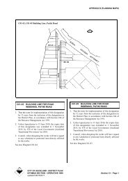
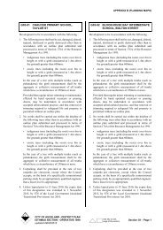
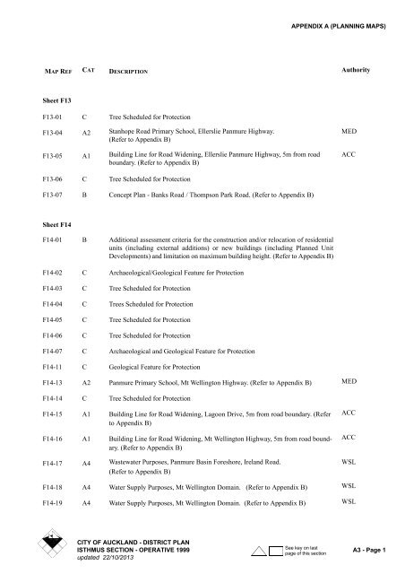
APPENDIX A (PLANNING MAPS)MAP REF CAT DESCRIPTION AuthoritySheet F13F13-01 C Tree Scheduled for ProtectionF13-04 A2 Stanhope Road Primary School, Ellerslie Panmure Highway.(Refer to Appendix B)F13-05 A1 Building Line for Road Widening, Ellerslie Panmure Highway, 5m from roadboundary. (Refer to Appendix B)MEDACCF13-06 C Tree Scheduled for ProtectionF13-07 B Concept Plan - Banks Road / Thompson Park Road. (Refer to Appendix B)Sheet F14F14-01 B Additional assessment criteria for the construction and/or relocation of residentialunits (including external additions) or new buildings (including Planned UnitDevelopments) and limitation on maximum building height. (Refer to Appendix B)F14-02 C Archaeological/Geological Feature for ProtectionF14-03 C Tree Scheduled for ProtectionF14-04 C Trees Scheduled for ProtectionF14-05 C Tree Scheduled for ProtectionF14-06 C Tree Scheduled for ProtectionF14-07 C Archaeological and Geological Feature for ProtectionF14-11 C Geological Feature for ProtectionF14-13 A2 Panmure Primary School, Mt Wellington Highway. (Refer to Appendix B) MEDF14-14 C Tree Scheduled for ProtectionF14-15 A1 Building Line for Road Widening, Lagoon Drive, 5m from road boundary. (Referto Appendix B)F14-16 A1 Building Line for Road Widening, Mt Wellington Highway, 5m from road boundary.(Refer to Appendix B)F14-17 A4 Wastewater Purposes, Panmure Basin Foreshore, Ireland Road.(Refer to Appendix B)ACCACCWSLF14-18 A4 Water Supply Purposes, Mt Wellington Domain. (Refer to Appendix B) WSLF14-19 A4 Water Supply Purposes, Mt Wellington Domain. (Refer to Appendix B) WSLCITY OF AUCKLAND - DISTRICT PLANSee key on lastISTHMUS SECTION - OPERATIVE 1999 A3 - Page 1page of this <strong>section</strong>updated 22/10/2013
APPENDIX A (PLANNING MAPS)MAP REF CAT DESCRIPTION AuthorityF15-50 C Tree Scheduled for ProtectionF15-52 C Tree Scheduled for ProtectionF15-53 A4 Telecommunication and Radiocommunication and Ancillary Purposes Telecom NZLSheet G03G03-01 A2 Chaucer Primary School, Taylor Street. (Refer to Appendix B) MEDG03-02 A2 Blockhouse Bay Intermediate School, Bolton Street. (Refer to Appendix B) MEDG03-03 A4 Wastewater Purposes, Miranda Street. (Refer to Appendix B) WSLG03-04 A1 Proposed Public Reserve, Wolverton Street Estuary. (Refer to Appendix B) ACCG03-05 A1 Proposed Public Reserve, Wolverton Street. (Refer to Appendix B) ACCG03-06 A4 New Zealand Refinery Pipeline NZRFCG03-07 A4 Gas transmission Pipeline Vector GasSheet G04G04-01 A2 Glenavon Primary School, Blockhouse Bay Road. (Refer to Appendix B) MEDG04-02 C Tree Scheduled for ProtectionG04-03 C Tree Scheduled for ProtectionG04-04 B Land subject to Additional Consents. 167 Whitney Street, Blockhouse Bay.(Refer to Appendix B)G04-05 C Building and Site Surrounds Scheduled for Protection (refer to APPENDIX B)Sheet G05G05-01 A4 Power Substation, White Swan Road. (Refer to Appendix B) TRNSPWRG05-02 A2 Lynfield College, White Swan Road. (Refer to Appendix B) MEDG05-03 A2 Marshall Laing Primary School, Marshall Laing Avenue. (Refer to Appendix B) MEDG05-04 A4 Electricity Transmission Purposes, Boundary Road TRNSPWRG05-05 A4 Electricity Transmission Purposes, Haycock Road TRNSPWRG05-06 A4 Electrical Works (Substation), White Swan Road VLCITY OF AUCKLAND - DISTRICT PLANSee key on lastA3 - Page 4 ISTHMUS SECTION - OPERATIVE 1999page of this <strong>section</strong>updated 22/10/2013
APPENDIX A (PLANNING MAPS)MAP REF CAT DESCRIPTION AuthoritySheet G06G06-01 A2 May Road Primary School, Richardson Road. (Refer to Appendix B) MEDG06-02 A2 Police Purposes: Community Policing Centre, Dominion Road MPOLICEG06-03 A4 Water Supply Purposes, Winstone Park. (Refer to Appendix B) WSLG06-04 C Archaeological/Geological Feature for ProtectionG06-06 A1 <strong>Council</strong> Carpark, Richardson Road. (Refer to Appendix B) ACCG06-07 C Tree Scheduled for Protection ACSheet G07G07-01 A2 Mt Roskill Primary School, Intermediate School and Mt. Roskill Grammar, FrostRoad. (Refer to Appendix B)MEDG07-06 C Tree Scheduled for ProtectionG07-07 C Tree Scheduled for Protection ACG07-08 C Tree Scheduled for Protection ACG07-09 C Tree Scheduled for Protection ACG07-10 C Tree Scheduled for Protection ACG07-11 C Tree Scheduled for Protection ACSheet G08G08-01 C Tree Scheduled for ProtectionG08-02 C Building Scheduled for Protection. (Refer to Appendix B)G08-03 A2 Onehunga High School, Pleasant Street. (Refer to Appendix B) MEDG08-04 A2 Three Kings Primary School, Mt Albert and Three Kings Road. (Refer toAppendix B)MEDG08-05 A4 Railway Purposes: Avondale Southdown Line NZRG08-06 C Building Scheduled for ProtectionG08-09 C Trees Scheduled for ProtectionG08-10 C Building Scheduled for Protection. (Refer to Appendix B)G08-11 C Trees Scheduled for ProtectionCITY OF AUCKLAND - DISTRICT PLANSee key on lastISTHMUS SECTION - OPERATIVE 1999 A3 - Page 5page of this <strong>section</strong>updated 22/10/2013
APPENDIX A (PLANNING MAPS)MAP REF CAT DESCRIPTION AuthorityG09-12 C Tree Scheduled for ProtectionG09-14 C Tree Scheduled for ProtectionG09-15 C Tree Scheduled for ProtectionG09-16 C Tree Scheduled for ProtectionG09-17 C Tree Scheduled for ProtectionG09-18 C Tree Scheduled for ProtectionG09-19 C Tree Scheduled for ProtectionG09-20 C Tree Scheduled for ProtectionG09-21 C Trees Scheduled for ProtectionG09-22 A1 Building Line for Corner Cut Off, Trafalgar and Selwyn Street inter<strong>section</strong>, southwest and south east 5m by 5m corner splays. (Refer to Appendix B)ACCG09-23 C Tree Scheduled for ProtectionG09-24 C Building Scheduled for ProtectionG09-25 C Building Scheduled for ProtectionG09-27 C Building Scheduled for ProtectionG09-28 C Building Scheduled for ProtectionG09-29 C Tree Scheduled for ProtectionG09-30 C Building Scheduled for ProtectionG09-31 A2 Royal Oak School, Manukau Road. (Refer to Appendix B) MEDG09-32 C Tree Scheduled for ProtectionG09-34 C Building Scheduled for ProtectionG09-35 C Tree Scheduled for ProtectionG09-36 C Tree Scheduled for ProtectionG09-37 C Building Scheduled for ProtectionG09-38 B Concept Plan - Mt Albert Road, Royal Oak. (Refer to Appendix B)G09-39 A1 Building Line for Road Widening, Manukau Road. (Refer to Appendix B) ACCG09-40 A1Refer toProposed Corner Cut Off, Manukau Road/Mt Smart Road.178(Refer to Appendix B)ACCG09-42 A1 Building Line for Road Widening, Campbell Road. (Refer to Appendix B) ACCCITY OF AUCKLAND - DISTRICT PLANSee key on lastISTHMUS SECTION - OPERATIVE 1999 A3 - Page 7page of this <strong>section</strong>updated 22/10/2013
APPENDIX A (PLANNING MAPS)MAP REF CAT DESCRIPTION AuthorityG10-03 C Tree Scheduled for ProtectionG10-04 C Tree Scheduled for ProtectionG10-06 C Trees Scheduled for ProtectionG10-07 C Tree Scheduled for ProtectionG10-08 C Tree Scheduled for ProtectionG10-09 C Tree Scheduled for ProtectionG10-10 C Tree Scheduled for ProtectionG10-11 C Tree Scheduled for ProtectionG10-12 C Tree Scheduled for ProtectionG10-14 C Tree Scheduled for ProtectionG10-16 C Tree Scheduled for ProtectionG10-17 C Tree Scheduled for ProtectionG10-18 C Building Scheduled for ProtectionG10-20 C Tree Scheduled for ProtectionG10-21 C Building Scheduled for ProtectionG10-22 C Building Scheduled for ProtectionG10-23 C Building Scheduled for ProtectionG10-24 C Tree Scheduled for ProtectionG10-25 C Tree Scheduled for ProtectionG10-26 C Building Scheduled for ProtectionG10-27 C Building Scheduled for ProtectionG10-31 C Geological Feature for ProtectionG10-34 C Geological Feature for ProtectionG10-36 A1 Building Line for Corner Cut Offs, Mt Smart Road and Onehunga Mallinter<strong>section</strong>, south-east corner 5m by 5m corner cut off. (Refer to Appendix B)ACCG10-39 C Tree Scheduled for ProtectionG10-40 C Tree Scheduled for ProtectionG10-41 C Trees Scheduled for ProtectionG10-42 C Tree Scheduled for ProtectionCITY OF AUCKLAND - DISTRICT PLANSee key on lastISTHMUS SECTION - OPERATIVE 1999 A3 - Page 9page of this <strong>section</strong>updated 22/10/2013
APPENDIX A (PLANNING MAPS)MAP REF CAT DESCRIPTION AuthorityG10-44 C Trees Scheduled for ProtectionG10-45 C Tree Scheduled for ProtectionG10-46 C Tree Scheduled for ProtectionG10-47 C Trees Scheduled for ProtectionG10-48 C Trees Scheduled for ProtectionG10-49 C Tree Scheduled for ProtectionG10-50 C Trees Scheduled for ProtectionG10-51 C Tree Scheduled for ProtectionG10-52 C Trees Scheduled for ProtectionG10-53 C Tree Scheduled for ProtectionG10-54 C Tree Scheduled for ProtectionG10-55 C Tree Scheduled for Protection305ACG10-57 C Tree Scheduled for ProtectionG10-58 C Tree Scheduled for ProtectionG10-59 C Building Scheduled for Protection (Refer to Appendix B)G10-60 C Tree Scheduled for Protection ACG10-61 C Tree Scheduled for Protection ACG10-62 C Trees Scheduled for Protection ACG10-63 A,C Tree Scheduled for Protection ACG10-64 C Tree Scheduled for Protection ACG10-65 C Tree Scheduled for Protection ACSheet G11G11-01 A2 Oranga Primary School, Rangipawa / Maroa Roads. (Refer to Appendix B) MEDG11-02 C Tree Scheduled for ProtectionG11-03 C Tree Scheduled for ProtectionG11-05 C Tree Scheduled for ProtectionG11-06 C Tree Scheduled for ProtectionCITY OF AUCKLAND - DISTRICT PLANSee key on lastA3 - Page 10 ISTHMUS SECTION - OPERATIVE 1999page of this <strong>section</strong>updated 22/10/2013
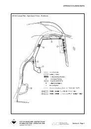
APPENDIX A (PLANNING MAPS)MAP REF CAT DESCRIPTION AuthorityG11-07 C Trees Scheduled for ProtectionG11-08 A2 Te Papapa Primary School, Mt Smart Road/Captain Springs Road. (Refer toAppendix B)G11-09 A1 Building Line for Road Widening, Felix Street, south side 3.05m from roadboundary. (Refer to Appendix B)MEDACCG11-10 B Concept Plan - Mt. Smart Stadium. (APPENDIX B)G11-12 A4 Electrical Works (Substation), Rockfield Road VLG11-13 A3 Mt Smart Sports and Entertainment Centre, Beasley Avenue/O'Rorke Road ARCG11-14 A1 Community Centre, Fergusson Domain. (Refer to Appendix B) ACCG11-16 C Tree Scheduled for ProtectionG11-18 C Trees Scheduled for ProtectionG11-19 C Tree Scheduled for ProtectionG11-20 C Tree Scheduled for ProtectionG11-21 C Tree Scheduled for ProtectionG11-22 C Trees Scheduled for ProtectionG11-23 C Tree Scheduled for ProtectionG11-25 C Tree Scheduled for Protection ACG11-26 C Tree Scheduled for Protection ACG11-27 C Tree Scheduled for Protection ACG11-28 C Tree Scheduled for Protection ACG11-29 C Tree Scheduled for Protection ACSheet G12G12-01 C Tree Scheduled for ProtectionG12-02 C Building Scheduled for ProtectionG12-04 C Tree Scheduled for ProtectionG12-06 A1 Building Line for Road Widening, Great South Road. (Refer to Appendix B) ACCG12-07 A4 Railway Purposes: Onehunga Branch Railway (Refer to Appendix B) NZRG12-08 A4 Electrical Works (Substation), McNab Street VLCITY OF AUCKLAND - DISTRICT PLANSee key on lastISTHMUS SECTION - OPERATIVE 1999 A3 - Page 11page of this <strong>section</strong>updated 22/10/2013
APPENDIX A (PLANNING MAPS)MAP REF CAT DESCRIPTION AuthorityG12-09 A1 Realignment of Great South Road at Penrose ACCSheet G13G13-01 C Tree Scheduled for ProtectionG13-02 C Tree Scheduled for ProtectionG13-03 C Tree Scheduled for ProtectionG13-04 C Tree Scheduled for ProtectionG13-05 C Tree Scheduled for ProtectionG13-06 C Tree Scheduled for ProtectionG13-07 C Tree Scheduled for ProtectionG13-08 C Tree Scheduled for ProtectionG13-09 A2 Sylvia Park Primary School, Longford Street. (Refer to Appendix B) MEDG13-10 A2 Bailey Road Primary School, Bailey Road. (Refer to Appendix B) MEDG13-12 A1 Building Line for Road Widening, off Mt Wellington Highway, south side 7.5mfrom southern boundary of Regional Road. (Refer to Appendix B)ACCG13-13 A4 Electricity Transmission Purposes, Barrack Road. (Refer to Appendix B) TRNSPWRG13-14 C Tree Scheduled for ProtectionG13-16 A1 Building Line for Road Widening, Great South Road, 5m from road boundary.(Refer to Appendix B)ACCG13-17 A1 <strong>Council</strong> Carpark, Mt Wellington Highway. (Refer to Appendix B) ACCG13-18 C Tree Scheduled for ProtectionSheet G14G14-02 C Tree Scheduled for ProtectionG14-04 C Building Scheduled for ProtectionG14-06 C Tree Scheduled for ProtectionG14-07 A1 Building Line for Road Widening, Carbine Road, east side 5m from roadboundary. (Refer to Appendix B)ACCG14-08 A4 Wastewater Purposes, Bowden Road. (Refer to Appendix B) WSLG14-09 C Tree Scheduled for ProtectionCITY OF AUCKLAND - DISTRICT PLANSee key on lastA3 - Page 12 ISTHMUS SECTION - OPERATIVE 1999page of this <strong>section</strong>updated 22/10/2013
APPENDIX A (PLANNING MAPS)MAP REF CAT DESCRIPTION AuthorityG14-10 C Tree Scheduled for ProtectionG14-11 C Tree Scheduled for ProtectionG14-12 C Trees Scheduled for ProtectionG14-14 B Concept Plan - Waipuna International Hotel and Conference Centre. (Refer toAppendix B).G14-15 B Concept Plan - Sylvia Park Business Centre. (Refer to Appendix B)G14-16 B Vehicle and Pedestrian Access Provisions - 77 Carbine Road (Refer to AppendixB)G14-17 B Concept Plan - Coca-Cola Amatil (NZ) Limited (Refer to Appendix B)Sheet G15G15-03 C Building Scheduled for ProtectionG15-04 C Tree Scheduled for ProtectionG15-05 C Tree Scheduled for ProtectionG15-07 C Tree Scheduled for ProtectionG15-08 C Trees Scheduled for ProtectionG15-09 C Trees Scheduled for ProtectionG15-10 A4 Underground Transmission LinesNote: Parts of this route are subject to existing designations. This designation is thelatest designation and the provisions of Section 177 of the Resource ManagementAct 1991 apply accordingly.TRNSPWRSheet H03H03-01 C Tree Scheduled for ProtectionH03-02 B Concept Plan - Powley House Village for the Aged and Disabled. (Refer toAppendix B)H03-03 C Tree Scheduled for ProtectionH03-04 A Blockhouse Bay to Green Bay ForestH03-05 B Craigavon BushH03-06 B Blockhouse Bay ForestH03-07 C Tree Scheduled for Protection ACCITY OF AUCKLAND - DISTRICT PLANSee key on lastISTHMUS SECTION - OPERATIVE 1999 A3 - Page 13page of this <strong>section</strong>updated 22/10/2013
APPENDIX A (PLANNING MAPS)MAP REF CAT DESCRIPTION AuthorityH03-08 C Tree Scheduled for Protection ACH03-09 C Tree Scheduled for Protection ACH03-10 C Tree Scheduled for Protection ACH03-11 C Tree Scheduled for Protection ACH03-12 A,C Tree Scheduled for Protection ACSheet H04H04-01 C Tree Scheduled for ProtectionH04-02 A2 Blockhouse Bay Primary School, Blockhouse Bay Road. (Refer to Appendix B) MEDH04-03 C Archaeological Feature for ProtectionH04-04 A1 <strong>Council</strong> Carpark, Blockhouse Bay Road. (Refer to Appendix B) ACCH04-05 C Tree Scheduled for ProtectionH04-06 A1 Library, Blockhouse Bay Road. (Refer to Appendix B) ACCH04-08 A Avondale South ForestH04-09 A Endeavour BushH04-10 A Blockhouse Bay Coastal Edge Forest 2H04-11 C Building and Site Surrounds Scheduled for Protection (refer to APPENDIX B)H04-12 C Building Scheduled for Protection (refer to APPENDIX B)H04-13 A4 Telecommunication and Radiocommunication and Ancillary Purposes Telecom NZLSheet H05H05-01 A2 Halsey Drive Primary School, Halsey Drive. (Refer to Appendix B) MEDH05-02 A4 Wastewater Purposes, Commodore Drive. (Refer to Appendix B) WSLH05-04 A4 Airport Approach Height Control. (<strong>Auckland</strong> International Airport Specificationfor Obstacle Limitation Surface). (Refer to Appendix B)AKLINAIRH05-05 B Wairaki ForestSheet H06H06-01 A2 Waikowhai Primary School, Hillsborough Road. (Refer to Appendix B) MEDCITY OF AUCKLAND - DISTRICT PLANSee key on lastA3 - Page 14 ISTHMUS SECTION - OPERATIVE 1999page of this <strong>section</strong>updated 22/10/2013
APPENDIX A (PLANNING MAPS)MAP REF CAT DESCRIPTION AuthorityH06-02 A1 Building Line for Corner Cut Offs, Hillsborough Road/Cape Horn Road. (Refer toAppendix B)H06-03 A1 Building Line for Corner Cut Offs, Hillsborough Road / Quona Avenue. (Refer toAppendix B)ACCACCH06-04 B Waikowhai Bay Revegetation 1H06-05 B Waikowhai Bay Revegetation 2H06-06 B Maungakiekie Golf Course BushSheet H07H07-01 A4 Tower Location, Richardson Road. (Refer to Appendix B) TRNSPWRH07-02 A2 Waikowhai Intermediate School, Richardson Road. (Refer to Appendix B) MEDH07-03 A2 Hay Park Primary School, Richardson Road. (Refer to Appendix B) MEDH07-04 A Wesley Bay / Grannys Bay ForestH07-08 A Goodall ForestH07-09 Concept Plan Monte Cecilia School/St John Vianney ParishSheet H08H08-01 A2 Hillsborough Primary School, Belfast Street. (Refer to Appendix B) MEDH08-02 A4 Wastewater Purposes, Frederick Street. (Refer to Appendix B) WSLH08-03 C Building Scheduled for ProtectionH08-04 C Geological Feature for ProtectionH08-05 A4 Road for State Highway/Motorway Purposes. (Extension of State Highway 20from Hillsborough Road to Maioro Road). (Refer to Appendix B)H08-06 A4 Road, Accessway or Service Lane for Access. (Extension of State Highway 20from Hillsborough Road to Maioro Road). (Refer to Appendix B)H08-07 A4 Road for Access to and/or for State Highway/Motorway Purposes. (Extension ofState Highway 20 from Hillsborough Road to Maioro Road).(Refer to Appendix B)TRANSITTRANSITTRANSITH08-10 A Belfast ForestSheet H09CITY OF AUCKLAND - DISTRICT PLANSee key on lastISTHMUS SECTION - OPERATIVE 1999 A3 - Page 15page of this <strong>section</strong>updated 22/10/2013
APPENDIX A (PLANNING MAPS)MAP REF CAT DESCRIPTION AuthorityH09-01 C Tree Scheduled for ProtectionH09-02 C Tree Scheduled for ProtectionH09-03 C Building Scheduled for ProtectionH09-04 C Additional Tree Protection, Hillsborough Cliffline. See Rule 5B.7.2BH09-06 C Trees Scheduled for ProtectionH09-08 C Building Scheduled for ProtectionH09-09 A2 Onehunga Periodic Detention Centre, Newsome Street. (Refer to Appendix B) MCORRH09-10 C Building Scheduled for ProtectionH09-11 C Building Scheduled for ProtectionH09-13 C View Protection, Onehunga Motorway Affected Areas. See Diagram H09-13Appendix C. See Rule 5C.7.6.14H09-14 A1 Building Line for Corner Cut Offs, Arthur Street and Selwyn Street, north-westand south-east 3m by 3m corner cut off. (Refer to Appendix B)H09-16 C Geological Feature for ProtectionH09-17 A1 Pedestrian Accessway, Hill Street to Catherine Street. (Refer to Appendix B) ACCH09-19 A4 Electrical Works (Substation), Selwyn Street and Arthur Street inter<strong>section</strong> VLH09-20 C Tree Scheduled for ProtectionH09-21 C Tree Scheduled for ProtectionH09-22 C Trees Scheduled for ProtectionH09-23 C Tree Scheduled for ProtectionH09-24 C Trees Scheduled for ProtectionH09-25 C Tree Scheduled for ProtectionH09-27 C Trees Scheduled for ProtectionH09-28 C Tree Scheduled for ProtectionH09-29 A1 Building Line for Road Widening, Neilson Street. (Refer to Appendix B).Sheet H10H10-01 A1 Building Line for Corner Cut Off, Princes Street and Selwyn Street inter<strong>section</strong>,north-west and south-west 3m by 3m corner cut off. (Refer to Appendix B)ACCH10-02 A2 Police Station, Onehunga Mall MPOLICECITY OF AUCKLAND - DISTRICT PLANSee key on lastA3 - Page 16 ISTHMUS SECTION - OPERATIVE 1999page of this <strong>section</strong>updated 22/10/2013
APPENDIX A (PLANNING MAPS)MAP REF CAT DESCRIPTION AuthorityH10-03 C Trees Scheduled for ProtectionH10-04 C Tree Scheduled for ProtectionH10-05 C Building Scheduled for ProtectionH10-06 C Trees Scheduled for ProtectionH10-07 A1 <strong>Council</strong> Carpark, Pearce Street. (Refer to Appendix B) ACCH10-08 C Building Scheduled for Protection. (Refer to Appendix B)H10-09 C Trees Scheduled for ProtectionH10-10 C Tree Scheduled for ProtectionH10-11 C Trees Scheduled for ProtectionH10-12 C Tree Scheduled for ProtectionH10-13 C Tree Scheduled for ProtectionH10-14 C Building Scheduled for ProtectionH10-15 C Building Scheduled for ProtectionH10-16 C Building Scheduled for ProtectionH10-17 C Building Scheduled for ProtectionH10-18 C Tree Scheduled for ProtectionH10-19 C Trees Scheduled for ProtectionH10-20 A1 Building Line for Road Widening, Arthur Street, south side 3.05m from roadboundary. (Refer to Appendix B)ACCH10-21 A4 Wastewater Purposes, Alfred Street, adjacent to railway. (Refer to Appendix B) WSLH10-22 A4 Water Supply Purposes, Water Filtration Station and Well Site, Princes, Rowe andSpring Streets. (Refer to Appendix B)WSLH10-23 A4 Water Supply Purposes, Pearce Street. (Refer to Appendix B) WSLH10-24 A4 Water Supply Purposes, Upper Municipal Place. (Refer to Appendix B) WSLH10-25 A4 Water Supply Purposes, Lower Municipal Place. (Refer to Appendix B) WSLH10-26 A4 Electricity Transmission Purposes, Onehunga Mall. (Refer to Appendix B) TRNSPWRH10-27 B Former Land Fill Areas. See Rule 8.7.3.3(6)H10-28 A1 Building Line for Corner Cut Offs, Church Street/Galway Street, 3m by 3m cornercut offs. (Refer to Appendix B)ACCH10-29 C Geological Feature for ProtectionCITY OF AUCKLAND - DISTRICT PLANSee key on lastISTHMUS SECTION - OPERATIVE 1999 A3 - Page 17page of this <strong>section</strong>updated 22/10/2013
APPENDIX A (PLANNING MAPS)MAP REF CAT DESCRIPTION AuthorityH10-30 A2 Onehunga Primary School, Selwyn Street. (Refer to Appendix B) MEDH10-31 A1 Water Protection Reserve, Spring Street Extension. (Refer to Appendix B) ACCH10-32 A1 Proposed Motorway Access Ramps, Gloucester Park. (Refer to Appendix B) ACCH10-33 A1 Proposed Service Lane, off Arthur Street, 6m width. (Refer to Appendix B) ACCH10-34 A1 <strong>Council</strong> Carpark, Waiapu Lane. (Refer to Appendix B) ACCH10-35 A1 <strong>Council</strong> Carpark, Waller Street South. (Refer to Appendix B) ACCH10-36 A1 <strong>Council</strong> Carpark, Paynes Lane. (Refer to Appendix B) ACCH10-38 C Building Scheduled for ProtectionH10-39 C Trees Scheduled for ProtectionH10-40 C Tree Scheduled for ProtectionH10-41 C Trees Scheduled for ProtectionH10-43 C Trees Scheduled for ProtectionH10-45 A1 Proposed Service Lane, extension of Waller Street North. (Refer to Appendix B,see Diagram H10-45)H10-46 A1 Proposed Road, Church Street extension. (Refer to Appendix B, see Diagram H10-45)H10-47 A1 Proposed Building Line for Road Widening Purposes, Waller Street North. (Referto Appendix B, see Diagram H10-45)H10-48 A1 Proposed Road, Gerard Beeson Place. (Refer to Appendix B, see Diagram H10-45)ACCACCACCACCH10-49 B Onehunga Centre Plan. (Refer to Appendix B, see Diagrams H10-45 and H10-49)H10-50 A1 Building Line for Road Widening, Neilson Street, (South side). (Refer to AppendixB)ACCH10-51 A Bycroft SpringsH10-52 A The Grotto WetlandH10-53 B The Grotto Wetland Riparian AreaH10-54 A4 Hunua No 4 - WaterCare (Refer to Appendix B) WSLH10-55 A4 Telecommunication and Radiocommunication and Ancillary Purposes Telecom NZLSheet H11H11-02 A1 Proposed Road, Miami Parade. (Refer to Appendix B) ACCCITY OF AUCKLAND - DISTRICT PLANSee key on lastA3 - Page 18 ISTHMUS SECTION - OPERATIVE 1999page of this <strong>section</strong>updated 22/10/2013
APPENDIX A (PLANNING MAPS)MAP REF CAT DESCRIPTION AuthorityH11-03 C Tree Scheduled for ProtectionH11-04 C Tree Scheduled for ProtectionH11-05 C Building Scheduled for ProtectionH11-06 A1 Building Line for Road Widening and Corner Cut Off, Captain Springs Road/Church Street. (Refer to Appendix B)H11-07 A1 Building Line for Corner Cut Off, Church Street and Mays Road inter<strong>section</strong>,north-east corner 3m by 3m corner cut off. (Refer to Appendix B)H11-08 A1 Building line for Corner Cut Offs, Captain Springs Road and Neilson Street inter<strong>section</strong>,5m by 5m all four corners. (Refer to Appendix B)ACCACCACCH11-10 A4 Wastewater Purposes, Miami Parade. (Refer to Appendix B) WSLH11-11 A4 <strong>Auckland</strong> Freight Centre, Neilson Street vicinity NZRH11-12 A1 Proposed Service Lane, Church Street, 6m width. (Refer to Appendix B) ACCH11-13 A1 Proposed Road, Pukemiro Street Extension. (Refer to Appendix B) ACCH11-14 A1 Proposed Roading Network, Pikes Point East and West. (Refer to Appendix B) ACCH11-15 A4 Electrical Works (Substation), Mays Road and Church Street inter<strong>section</strong> VLH11-16 A3 Refuse Processing Station, Angle Street/Captain Springs Road Extn. (Refer toAppendix B)H11-18 A1 Proposed Road, Pukerimo Street, Miami Parade to the Manukau Esplanade.(Refer to Appendix B)H11-19 A1 Building Line for Road Widening, and Corner Cut Off, Neilson Street and AngleStreet, 2.45m from road boundary, and a 5m by 5m corner cut off on both cornersof Angle Street. (Refer to Appendix B)ARCACCACCH11-20 C Building Scheduled for ProtectionH11-21 B Captain Springs NorthH11-22 B Captain Springs SouthH11-23 A Pikes Point Lava IsletsH11-24 A1 Sports Fields / Open Space Purposes, 69 Captain Springs Road ACCSheet H12H12-01 C Tree Scheduled for ProtectionH12-02 A1 Building Line for Road Widening, Church Street, both sides 2.74m from roadboundary. (Refer to Appendix B)ACCCITY OF AUCKLAND - DISTRICT PLANSee key on lastISTHMUS SECTION - OPERATIVE 1999 A3 - Page 19page of this <strong>section</strong>updated 22/10/2013
APPENDIX A (PLANNING MAPS)MAP REF CAT DESCRIPTION AuthorityH12-03 A4 Wastewater Purposes, Neilson Street. (Refer to Appendix B) WSLH12-05 A Manukau Foreshore East Lava OutcropsSheet H13H13-01 C Tree Scheduled for ProtectionH13-02 C Archaeological Feature for ProtectionH13-03 A4 Electrical Works (Substation), Great South Road VLH13-04 A3 Proposed Regional Park, Hamlins Hill/Great South Road ARCH13-05 C Tree Scheduled for ProtectionH13-06 A4 Wastewater Purposes, cnr Sylvia Park Road and Great South Road. (Refer toAppendix B)WSLH13-07 A4 Wastewater Purposes, Bell Avenue. (Refer to Appendix B) WSLH13-08 A4 Water Supply Purposes, cnr Great South Road and Sylvia Park Road. (Refer toAppendix B)H13-09 A4 Railway Purposes: North <strong>Auckland</strong> Railway. (Refer to Appendix B. See DiagramB09-06)WSLNZRH13-10 A1 Building Line for Road Widening, Great South Road. (Refer to Appendix B) ACCH13-11 C Geological Feature for ProtectionH13-14 C Tree Scheduled for ProtectionH13-15 C Tree Scheduled for ProtectionH13-16 C Tree Scheduled for ProtectionH13-17 C Trees Scheduled for ProtectionH13-18 C Concept Plan - Pacific Rise Business Centre. (Refer to Appendix B)H13-21 A Anns Creek Coastal Margin 1H13-22 A Anns Creek Coastal Margin 3H13-23 A Anns Creek Coastal Margin 2[H13-24 A Anns Creek Lava Flow Wetland and Shrubland]88H13-25 B Anns Creek Reserve Stormwater WetlandH13-26 A4 Westfield to Southdown Gas Pipeline (Refer to Appendix B) Vector GasCITY OF AUCKLAND - DISTRICT PLANSee key on lastA3 - Page 20 ISTHMUS SECTION - OPERATIVE 1999page of this <strong>section</strong>updated 22/10/2013
APPENDIX A (PLANNING MAPS)MAP REF CAT DESCRIPTION AuthoritySheet H14H14-01 C Tree Scheduled for ProtectionH14-03 C Tree Scheduled for ProtectionH14-04 C Tree Scheduled for ProtectionH14-05 C Tree Scheduled for ProtectionH14-08 C Tree Scheduled for ProtectionH14-09 C Tree Scheduled for ProtectionH14-10 A2 Panama Road Primary School, Panama Road. (Refer to Appendix B) MEDH14-11 C Archaeological Feature for ProtectionH14-12 A4 Electrical Works (Substation), Carbine Road VLH14-13 C Trees Scheduled for ProtectionH14-14 C Tree Scheduled for ProtectionH14-15 C Trees Scheduled for ProtectionSheet I06I06-01 A Blockhouse Bay to Waikowhai ForestI06-02 A Waikowhai Bay Walkway ForestSheet I13I13-01 C Building Scheduled for ProtectionI13-04 A2 Otahuhu Primary School, Station Road. (Refer to Appendix B) MEDI13-05 A4 Wastewater Purposes, Saleyards Road. (Refer to Appendix B) WSLI13-06 A4 Wastewater Purposes, Saleyards Road. (Refer to Appendix B) WSLI13-07 C Archaeological/Geological Feature for ProtectionI13-08 C Tree Scheduled for ProtectionI13-09 C Trees Scheduled for ProtectionI13-10 C Trees Scheduled for Protection ACSheet I14CITY OF AUCKLAND - DISTRICT PLANSee key on lastISTHMUS SECTION - OPERATIVE 1999 A3 - Page 21page of this <strong>section</strong>updated 22/10/2013
APPENDIX A (PLANNING MAPS)MAP REF CAT DESCRIPTION AuthorityI14-01 C Tree Scheduled for ProtectionI14-02 C Tree Scheduled for ProtectionI14-03 C Building Scheduled for ProtectionI14-04 C Tree Scheduled for ProtectionI14-05 A1 <strong>Council</strong> Carpark, King Street. (Refer to Appendix B) ACCI14-06 C Building Scheduled for ProtectionI14-08 A1 <strong>Council</strong> Carpark, between Station Road and Mason Avenue.(Refer to Appendix B)ACCI14-09 A1 <strong>Council</strong> Carpark, between Mason Avenue and Hall Avenue. (Refer to Appendix B) ACCI14-10 C Tree Scheduled for ProtectionI14-11 C Building Scheduled for ProtectionI14-12 C Building Scheduled for ProtectionI14-13 C Tree Scheduled for ProtectionI14-14 C Tree Scheduled for ProtectionI14-15 C Tree Scheduled for ProtectionI14-16 A2 Otahuhu Intermediate School, Luke Street. (Refer to Appendix B) MEDI14-17 A2 Mt Richmond Primary School, Albion Road. (Refer to Appendix B) MEDI14-19 A2 Police Station, Great South Road/Princes Street MPOLICEI14-20 A1 Building Line for Road Widening, Atkinson Avenue, both sides 3m from roadboundary. (Refer to Appendix B)I14-21 A1 Building Line for Corner Cut Off, Atkinson Avenue and Princes Street. (Refer toAppendix B)I14-22 A1 Building Line for Corner Cut Off, Trenwith/Water/High Streets. (Refer to AppendixB)ACCACCACCI14-23 A4 Electricity Transmission Purposes, Luke Street. (Refer to Appendix B) TRNSPWRI14-24 A4 Wastewater Purposes, Portage Road East. (Refer to Appendix B) WSLI14-25 C Trees Scheduled for ProtectionI14-26 A1 Proposed Service Lane, Station Road running parallel to Great South Road. (Referto Appendix B)I14-27 A1 Proposed Service Lane, Station Road to Mason Avenue. (Refer to Appendix B,see Diagram I14-26)ACCACCCITY OF AUCKLAND - DISTRICT PLANSee key on lastA3 - Page 22 ISTHMUS SECTION - OPERATIVE 1999page of this <strong>section</strong>updated 22/10/2013
APPENDIX A (PLANNING MAPS)MAP REF CAT DESCRIPTION AuthorityI14-31 A1 <strong>Council</strong> Carpark, High Street. (Refer to Appendix B) ACCI14-32 B Otahuhu Centre Plan. (Refer to Appendix B).I14-34 A1 Proposed Pedestrian Mall, Criterion Street. (Refer to Appendix B) ACCI14-36 C Tree Scheduled for ProtectionI14-37 C Tree Scheduled for ProtectionI14-38 A4 Otahuhu Southern Motorway Interchange (Refer to Appendix B) TRANSITI14-39 A1 Multi-purpose community and recreation facilities (Refer to Appendix B) ACCI14-40 A2 Special School, 32-44 Luke Street, Otahuhu MEDSheet I15I15-01 C Tree Scheduled for ProtectionI15-05 A1 Building Line for Road Widening, Frank Grey Place, both sides 10m from centreline of street. (Refer to Appendix B)ACCI15-06 A4 Wastewater Purposes, end of Luke Street East. (Refer to Appendix B) WSLI15-07 C Trees Scheduled for ProtectionSheet J13J13-01 C Tree Scheduled for ProtectionJ13-02 C Tree Scheduled for ProtectionJ13-03 C Trees Scheduled for ProtectionJ13-04 C Tree Scheduled for ProtectionJ13-05 C Building Scheduled for ProtectionJ13-06 C Building Scheduled for ProtectionJ13-07 A2 Otahuhu College, School and Sports Grounds, Mangere Road (both sides). (Referto Appendix B)J13-08 A1 Building Line for Corner Cut Off, Walmsley and Mangere inter<strong>section</strong>. (Refer toAppendix B)MEDACCJ13-09 B Concept Plan - Kings College. (Refer to Appendix B)J13-10 A4 Electrical Works (Substation), Hans Street VLJ13-11 C Building Scheduled for ProtectionCITY OF AUCKLAND - DISTRICT PLANSee key on lastISTHMUS SECTION - OPERATIVE 1999 A3 - Page 23page of this <strong>section</strong>updated 22/10/2013
APPENDIX A (PLANNING MAPS)MAP REF CAT DESCRIPTION AuthoritySheet J14J14-01 C Building Scheduled for ProtectionJ14-04 C Tree Scheduled for ProtectionJ14-05 C Tree Scheduled for ProtectionJ14-06 C Tree Scheduled for ProtectionJ14-08 C Tree Scheduled for ProtectionJ14-09 C Building Scheduled for ProtectionJ14-10 C Tree Scheduled for ProtectionJ14-11 A2 Education Department Activity Centre, Beatty Street/Great South Road. (Refer toAppendix B)MEDJ14-12 C Building Scheduled for ProtectionJ14-13 C Building Scheduled for ProtectionJ14-14 C Building Scheduled for ProtectionJ14-15 C Tree Scheduled for ProtectionJ14-16 A2 Periodic Detention Centre, Fort Richard Road. (Refer to Appendix B) MCORRJ14-17 A2 Fairburn Road School, Fairburn Road. (Refer to Appendix B) MEDJ14-17a A2 Fairburn Road School. (Refer to Appendix B) MEDJ14-18 A4 Water Supply Purposes, Cracroft Street. (Refer to Appendix B) WSLJ14-19 A1Refer toBuilding Line for Corner Cut Off, Great South Road and FairburnRoad. (Refer to Appendix180B)ACCJ14-21 A1 <strong>Council</strong> Carpark, Victoria Street (cnr Park Avenue). (Refer to Appendix B) ACCJ14-23 C Tree Scheduled for ProtectionJ14-24 C Geological Feature for ProtectionJ14-25 A2 Northern Region Police Headquarters. (Refer to Appendix B) MPOLICEJ14-26 A4 Telecommunication and Radiocommunication and Ancillary Purposes Telecom NZLCITY OF AUCKLAND - DISTRICT PLANSee key on lastA3 - Page 24 ISTHMUS SECTION - OPERATIVE 1999page of this <strong>section</strong>updated 22/10/2013
APPENDIX A (PLANNING MAPS)Plan change annotations - keyxIndicates where content is affected by proposed plan modification x.Refer to plan modification folder or website for details.xIndicates where the content is part of plan modification x, which is subject to appeal.Underlined content to be inserted.Struck through content to be deleted.CITY OF AUCKLAND - DISTRICT PLANSee key on lastISTHMUS SECTION - OPERATIVE 1999 A3 - Page 25page of this <strong>section</strong>updated 22/10/2013