

Great Sandy Marine Park Visitor Guide - Department of National ...
Great Sandy Marine Park Visitor Guide - Department of National ...
Great Sandy Marine Park Visitor Guide - Department of National ...

You also want an ePaper? Increase the reach of your titles
YUMPU automatically turns print PDFs into web optimized ePapers that Google loves.
Ck<br />
ek<br />
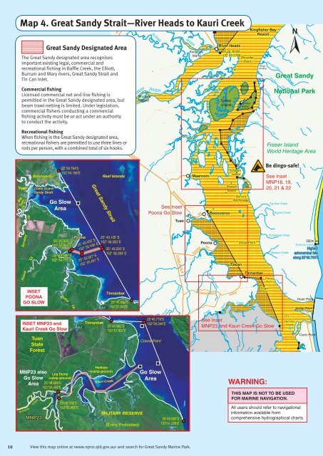
Map 4. <strong>Great</strong> <strong>Sandy</strong> Strait—River Heads to Kauri Creek<br />
HERVE<br />
SUSAN<br />
Kingfisher Bay<br />
Resort<br />
<strong>Great</strong> <strong>Sandy</strong> Designated Area<br />
The <strong>Great</strong> <strong>Sandy</strong> designated area recognises<br />
important existing legal, commercial and<br />
recreational fishing in Baffle Creek, the Elliott,<br />
Burrum and Mary rivers, <strong>Great</strong> <strong>Sandy</strong> Strait and<br />
Tin Can Inlet.<br />
RIVER<br />
Kangaroo<br />
Island<br />
River Heads<br />
25 25. 819S<br />
152 55.576E<br />
Shoulder<br />
Point<br />
Barge<br />
Landing<br />
Wanggoolba<br />
Rocky<br />
<strong>Great</strong> <strong>Sandy</strong><br />
Creek<br />
Commercial fishing<br />
Licensed commercial net and line fishing is<br />
permitted in the <strong>Great</strong> <strong>Sandy</strong> designated area, but<br />
beam trawl netting is limited. Under legislation,<br />
commercial fishers conducting a commercial<br />
fishing activity must be or act under an authority<br />
to conduct the activity.<br />
MARY<br />
Brothers<br />
Island<br />
RIVER<br />
Turkey<br />
Island<br />
Walsh<br />
Island<br />
Bookar<br />
Island<br />
Yankee<br />
Alligator<br />
Ungowa Ck<br />
Ck<br />
Buff Ck Ck<br />
Jack<br />
Ck<br />
<strong>National</strong> <strong>Park</strong><br />
Recreational fishing<br />
When fishing in the <strong>Great</strong> <strong>Sandy</strong> designated area,<br />
recreational fishers are permitted to use three lines or<br />
rods per person, with a combined total <strong>of</strong> six hooks.<br />
MARYBOROUGH<br />
Creek<br />
Fraser Island<br />
World Heritage Area<br />
Big<br />
Tuan<br />
Tuan<br />
Ck<br />
Boonooroo<br />
Coast Guard<br />
<strong>Sandy</strong> Strait<br />
Go Slow<br />
Area<br />
25°39.764’S<br />
152°54.196’E<br />
<strong>Great</strong> <strong>Sandy</strong> Strait<br />
Reef Islands<br />
Kolah<br />
BOONOOROO<br />
See Inset<br />
Poona Go Slow<br />
Maaroom<br />
RD<br />
Boonooroo<br />
Dream<br />
Island<br />
Stewart<br />
Island<br />
Garry’s<br />
Anchorage<br />
Be dingo-safe!<br />
See Inset<br />
MNP18, 19,<br />
20, 21 & 22<br />
Fig Tree Creek<br />
August Creek<br />
Tuan<br />
Scrubby<br />
Ck<br />
25° 43.302' S<br />
152° 54.884' E<br />
25° 43.386' S<br />
152° 54.775' E<br />
Poona<br />
25° 43.452' S<br />
152° 55.446' E<br />
25° 43.567' S<br />
152° 55.451' E<br />
25° 43.135' S<br />
152° 56.333' E<br />
25° 43.230' S<br />
152° 56.393' E<br />
POONA<br />
Poona<br />
RD<br />
Tawan<br />
Snout Point<br />
Tootawwah Creek<br />
Geewan Creek<br />
500m<br />
Tooloora Creek<br />
Highest<br />
astronomical tide<br />
along 25°42.700’S<br />
COOLOOLA<br />
Poona<br />
Buttha<br />
Tinnanbar<br />
Elbow<br />
Point<br />
INSET<br />
POONA<br />
GO SLOW<br />
INSET MNP23 and<br />
Kauri Creek Go Slow<br />
Tuan<br />
State<br />
Forest<br />
Butha<br />
Ck<br />
Tinnanbar<br />
Tinnanbar<br />
25°45.662’S<br />
152°57.902’E<br />
25°45.662’S<br />
152°57.902’E<br />
Cowra Point<br />
Poona<br />
25°45.779’S<br />
152°59.344’E<br />
Creek<br />
Mosquito<br />
TINNANBAR<br />
Creek<br />
Creek<br />
Kauri<br />
Kauri<br />
ROAD<br />
Creek<br />
Creek<br />
Cowra<br />
Point<br />
See Inset<br />
MNP23 and Kauri Creek Go Slow<br />
Creek<br />
TIN<br />
Pannikin<br />
Island<br />
M<br />
Hook Point<br />
Inskip Point<br />
Carlo Point<br />
MNP23 also<br />
Go Slow<br />
Area<br />
Mosquito<br />
Creek<br />
MNP23<br />
Log Dump<br />
(camp ground)<br />
25°48.668’S<br />
152°55.448’E<br />
25°48.978’S<br />
152°55.483’E<br />
Hedleys<br />
(camp ground)<br />
Kauri Creek<br />
MILITARY RESERVE<br />
(Entry Prohibited)<br />
Go Slow<br />
Area<br />
25°49.882’S<br />
153°01.228’E<br />
WARNING:<br />
THIS MAP IS NOT TO BE USED<br />
FOR MARINE NAVIGATION.<br />
All users should refer to navigational<br />
information available from<br />
comprehensive hydrographical charts.<br />
10<br />
View this map online at and search for <strong>Great</strong> <strong>Sandy</strong> <strong>Marine</strong> <strong>Park</strong>.


