

Great Sandy Marine Park Visitor Guide - Department of National ...
Great Sandy Marine Park Visitor Guide - Department of National ...
Great Sandy Marine Park Visitor Guide - Department of National ...

You also want an ePaper? Increase the reach of your titles
YUMPU automatically turns print PDFs into web optimized ePapers that Google loves.
<strong>Department</strong> <strong>of</strong> <strong>National</strong> <strong>Park</strong>s, Recreation, Sport and Racing<br />
<strong>Great</strong> <strong>Sandy</strong><br />
<strong>Marine</strong> <strong>Park</strong><br />
<strong>Visitor</strong> guide<br />
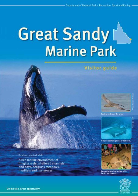
Eastern curlew on the wing.<br />
Photo: Qld Govt. Photo: Dorothy Pashniak<br />
Grey nurse shark gather at Wolf Rock.<br />
Breaching humpback whale.<br />
A rich marine environment <strong>of</strong><br />
fringing reefs, sheltered channels<br />
and bays, seagrass meadows,<br />
mudflats and mangroves.<br />
Encounter marine turtles, with<br />
family and friends.<br />
Photo: Qld Govt.<br />
<strong>Great</strong> state. <strong>Great</strong> opportunity.
Welcome to<br />
<strong>Great</strong> <strong>Sandy</strong> <strong>Marine</strong> <strong>Park</strong><br />
Access<br />
The <strong>Great</strong> <strong>Sandy</strong> <strong>Marine</strong> <strong>Park</strong> extends from<br />
Baffle Creek in the north to Double Island<br />
Point in the south. It includes Hervey Bay,<br />
<strong>Great</strong> <strong>Sandy</strong> Strait, Tin Can Inlet and the<br />
waters <strong>of</strong>f the east coast <strong>of</strong> Fraser Island,<br />
seaward to three nautical miles.<br />
The park is easily accessed from coastal<br />
towns and boat ramps from Rules Beach<br />
north <strong>of</strong> Bundaberg to Rainbow Beach on<br />
the Cooloola Coast, and from marinas in<br />
Bundaberg, Urangan, and Tin Can Bay.<br />
Management<br />
The <strong>Department</strong> <strong>of</strong> <strong>National</strong> <strong>Park</strong>s,<br />
Recreation, Sport and Racing’s (NPRSR)<br />
Queensland <strong>Park</strong>s and Wildlife Service<br />
(QPWS) manages the <strong>Great</strong> <strong>Sandy</strong><br />
<strong>Marine</strong> <strong>Park</strong>.<br />
The marine park <strong>of</strong>fers a wide range <strong>of</strong><br />
recreational, research and commercial<br />
opportunities. Its tidal lands and marine<br />
waters form a transition zone between<br />
tropical and temperate waters, where<br />
changing water temperatures drive<br />
unique and dynamic life cycles and<br />
influence marine habitats, communities<br />
and wildlife.<br />
Zoning<br />
Conservation—along with the reasonable<br />
use <strong>of</strong> significant marine natural resources<br />
—is achieved through a zoning plan<br />
consisting <strong>of</strong> five zones, nine designated<br />
areas, and a system <strong>of</strong> regulations<br />
and permits.<br />
The zones range from no-take marine<br />
national park zones—green zones—to<br />
general use zones. For more information<br />
see page 3.<br />
What is a designated area?<br />
Designated areas allow for the<br />
management <strong>of</strong> issues that occur<br />
seasonally, such as protection for<br />
migratory shorebirds, whales, marine<br />
turtles and dugong. The purpose and<br />
management provisions <strong>of</strong> designated<br />
areas are in addition to the purpose and<br />
provisions <strong>of</strong> the zones in which the<br />
designated areas are located.<br />
<strong>Great</strong> <strong>Sandy</strong> <strong>Marine</strong> <strong>Park</strong>—know your zones and designated areas.<br />
Baffle<br />
Creek<br />
Legend<br />
Map 1 page 4<br />
<strong>Great</strong> <strong>Sandy</strong><br />
<strong>Marine</strong> <strong>Park</strong><br />
Bundaberg Port<br />
Burnett Heads<br />
Rooney Point<br />
Map 3 page 8<br />
Platypus<br />
Bundaberg<br />
<strong>Great</strong> <strong>Sandy</strong><br />
Bay<br />
<strong>Marine</strong> <strong>Park</strong><br />
Bundaberg Port<br />
Find a map<br />
Major selaed road<br />
Minor sealed road<br />
Woodgate<br />
Point<br />
Vernon<br />
Scale<br />
0 20km<br />
Map 2 page 6<br />
Breaksea Spit<br />
Urangan<br />
Boat<br />
Harbour<br />
Maryborough<br />
Moon<br />
Point<br />
Fraser<br />
Island<br />
<strong>Sandy</strong><br />
Cape<br />
Map 4 page 10<br />
Map 5 page 12<br />
Rainbow Beach<br />
Double<br />
Island Point<br />
Map 1. Woongarra Coast to Woodgate Pages 4–5<br />
Map 2. Southern Gutter; Platypus Bay; Rooney Point to<br />
<strong>Sandy</strong> Cape; Point Vernon to Moon Point Pages 6–7<br />
Map 3. Hervey Bay: Burrum Heads to Urangan;<br />
Northern channels <strong>of</strong> <strong>Great</strong> <strong>Sandy</strong> Strait Pages 8–9<br />
Map 4. <strong>Great</strong> <strong>Sandy</strong> Strait: River Heads to Kauri Creek Pages 10–11<br />
Map 5 <strong>Great</strong> <strong>Sandy</strong> Strait: Kauri Creek to<br />
Double Island Point including Tin Can Inlet Pages 12–13<br />
Find a designated area<br />
Mon Repos designated area Page 4<br />
Turtle protection area Page 4<br />
Turtle monitoring area Page 4<br />
Whale management area Page 7<br />
Fish trap area Page 8<br />
Go Slow Designated Area Page 9<br />
<strong>Great</strong> <strong>Sandy</strong> Designated Area Page 10<br />
Shorebird roosting and feeding area Page 11<br />
Grey Nurse Shark Designated Area Page 13<br />
—Wolf Rock—<strong>Marine</strong> <strong>National</strong> <strong>Park</strong> Zone<br />
Things to Know<br />
What is a hook? Page 7<br />
Staying safe and best practice guide Page 14–15<br />
Permits, fees and contacts Page 16<br />
2
Get to know the<br />
five zones<br />
1. <strong>Marine</strong> national park zones<br />
<strong>Marine</strong> national park zones—green<br />
zones—provide the greatest level <strong>of</strong><br />
protection for areas <strong>of</strong> high natural and<br />
ecological value. <strong>Marine</strong> national park<br />
zones are identified on the zoning map<br />
in green. They are ‘look but don’t take’<br />
zones where activities such as diving<br />
and photography are allowed, but fishing<br />
and collecting are prohibited. All fishing<br />
equipment must be stowed and secured<br />
prior to entering a green zone.<br />
2. Buffer zones<br />
Buffer zones have the same entry and use<br />
provisions as marine national park zones,<br />
but allow for trolling for pelagic species.<br />
They are identified on the zoning map in<br />
olive green. An area around the marine<br />
national park zone at Wolf Rock is currently<br />
the only buffer zone in the <strong>Great</strong> <strong>Sandy</strong><br />
<strong>Marine</strong> <strong>Park</strong>.<br />
3. Conservation park zones<br />
Conservation park zones—yellow zones—<br />
protect significant marine habitats.<br />
Commercial netting, trawling and harvest<br />
fishing are prohibited. Restrictions apply<br />
to most other activities.<br />
Line fishing is limited to one line or<br />
rod and one hook or lure per person.<br />
When trolling, each person is limited to<br />
a maximum <strong>of</strong> three lines or rods with<br />
a combined total <strong>of</strong> six hooks. Where<br />
crabbing is permitted, only four catch<br />
devices may be used per person.<br />
The <strong>Great</strong> <strong>Sandy</strong> designated area that<br />
overlays conservation park zone allows for<br />
additional commercial and recreational<br />
fishing which is different from those in<br />
the rest <strong>of</strong> the conservation park zone. For<br />
more information about the <strong>Great</strong> <strong>Sandy</strong><br />
designated area see page 10.<br />
4. Habitat protection zones<br />
Habitat protection zones are coloured in<br />
dark blue. They are located over areas<br />
that contain sensitive habitats. Trawling is<br />
prohibited in the habitat protection zones,<br />
but most other activities are allowed.<br />
5. General use zone<br />
The light blue general use zone covers<br />
all remaining areas <strong>of</strong> the marine park.<br />
These zones provide both conservation<br />
and reasonable use. Commercial activities<br />
require a permit, but most other activities<br />
are allowed.<br />
<strong>Great</strong> <strong>Sandy</strong> <strong>Marine</strong> <strong>Park</strong>—Zones<br />
November 2012<br />
Provisions Table (What you can do and where)<br />
Entry and use provisions<br />
General use<br />
zone<br />
Habitat<br />
protection zone<br />
Conservation<br />
park zone<br />
Buffer zone<br />
<strong>Marine</strong><br />
national park<br />
zone<br />
FISHERIES, FISHING AND COLLECTING ACTIVITIES<br />
Bait netting Yes 9 Yes 9 Yes 9 No A No A<br />
Aquaculture Permit Permit Permit No A No A<br />
Crabbing Yes 9 Yes 9 Yes 2,9 No A No A<br />
Bait gathering Yes 9 Yes 9 Yes 9 No A No A<br />
Line fishing Yes 4,9 Yes 4,9 Yes 5,9 No A No A<br />
Limited collecting Yes 3,9 Yes 3,9 Yes 3,9 No A No A<br />
Limited spearfishing (snorkel only) Yes 9 Yes 9 Yes 9 No A No A<br />
Traditional use <strong>of</strong> marine resources Yes 6 Yes 6 Yes 6 Yes 6 Yes 6<br />
Trolling Yes 4,9 Yes 4,9 Yes 4,9 Yes 4,7,9 No A<br />
Commercial netting (other than<br />
bait netting)<br />
Yes 9 Yes 9 No 8,9 No A No A<br />
Harvest fishing for aquarium fish, coral<br />
and beachworm<br />
Harvest fishing for sea cucumber,<br />
trochus, tropical rock lobster<br />
Permit 1 Permit 1 Permit No A No A<br />
Permit 1 Permit 1 No No A No A<br />
Trawling Yes 9 No No No A No A<br />
OTHER ACTIVITIES<br />
Boating, diving, photography Yes Yes Yes Yes Yes<br />
Research (other than limited impact) Permit Permit Permit Permit Permit<br />
Shipping (other than in a<br />
designated shipping area)<br />
Yes Permit Permit Permit Permit<br />
Tourism program Permit Permit Permit Permit Permit<br />
NOTES ON ENTRY AND USE PROVISIONS<br />
A. All fishing equipment must be stowed and secured prior to entering a buffer zone<br />
or green zone.<br />
1.<br />
2.<br />
3.<br />
4.<br />
5.<br />
Other than an accredited harvest fishery.<br />
Limited to 4 catch devices (e.g. crab pots or dillies) per person.<br />
By hand or hand-held implement.<br />
Maximum <strong>of</strong> 3 lines/rods per person with a combined total <strong>of</strong> 6 hooks.<br />
Limited to 1 line/rod per person and 1 hook/lure per line (except the <strong>Great</strong> <strong>Sandy</strong><br />
Area which is as per note 4).<br />
6. Activities that are not “as <strong>of</strong> right” in the zone, or that involve the take <strong>of</strong> protected species<br />
require either a permit or a Traditional Use <strong>of</strong> <strong>Marine</strong> Resources Agreement.<br />
7.<br />
8.<br />
Pelagic species only.<br />
Commercial fishers holding <strong>Department</strong> <strong>of</strong> Agriculture, Fisheries and Forestry<br />
endorsements can continue commercial fishing activities within the <strong>Great</strong> <strong>Sandy</strong><br />
Designated Area.<br />
9. All fishing activities must comply with restrictions or conditions placed upon them<br />
by the Fisheries Act and Regulation.<br />
Note: Permits are required for most other activities not listed above. Designated Areas<br />
may provide additional restrictions at some locations. The zoning plan does not<br />
affect the operation <strong>of</strong> s.2.11 <strong>of</strong> the Native Title Act 1993.<br />
Other management provisions.<br />
Vessels may travel on the plane in <strong>of</strong>ficial marine park transit lanes.<br />
View the transit lanes at and search for<br />
<strong>Great</strong> <strong>Sandy</strong> <strong>Marine</strong> <strong>Park</strong>.<br />
3
Map 1. Woongarra Coast to Woodgate<br />
Baffle Creek<br />
Commonwealth<br />
Waters<br />
Littabella Creek<br />
KOLAN RIVER<br />
Moore <strong>Park</strong><br />
BUNDABERG<br />
PORT<br />
Turtle encounters<br />
Mon Repos Conservation <strong>Park</strong> supports the most significant nesting<br />
population—about 300–400 females <strong>of</strong> the endangered Loggerhead turtle<br />
Caretta caretta—in the southern hemisphere. Green and flatback turtles also<br />
nest at Mon Repos with thousands <strong>of</strong> people visiting Mon Repos each year to<br />
view turtles. QPWS manages visitors and potential impacts through ticketed<br />
beach access. The whole family can learn about marine turtles through the<br />
turtle encounters program and the centre’s interpretive displays. Children are<br />
welcome to participate in the ranger-led, junior turtle ranger activities. Bookings<br />
are essential and can be confirmed by contacting Bundaberg North Burnett<br />
Tourism on (07) 4153 8888. Please remember that domestic animals are not<br />
allowed in the conservation park as they are not permitted in protected areas.<br />
Bundaberg<br />
BURNETT<br />
RIVER<br />
24°45.400’S<br />
152°24.958’E<br />
Mon Repos<br />
Conservation <strong>Park</strong><br />
Burnett<br />
Heads<br />
Mon Repos marine turtle designated area<br />
Entry and use provisions apply from 15 October to 30 April:<br />
• Only authorised vehicles can access the foreshore for the purpose <strong>of</strong><br />
management or <strong>of</strong>ficial monitoring <strong>of</strong> marine turtles.<br />
• Domestic animals are not allowed to enter the designated area.<br />
Between 6 pm and 6 am:<br />
• Swimming, fishing or the use <strong>of</strong> a vessel is not permitted.<br />
• Torches must be small and not more than three volts. It is an <strong>of</strong>fence to<br />
project a light that changes the ambient light in the area as this may<br />
disturb marine turtles.<br />
Ranger’s directions must be followed.<br />
HIGH<br />
WAY<br />
Burnett<br />
Heads<br />
BUNDABERG<br />
PORT<br />
Mon Repos<br />
Conservation <strong>Park</strong><br />
Turtle protection area<br />
Bagara<br />
NORTH COAST RAILWAY<br />
The turtle protection area aims to protect marine turtles and their habitat,<br />
and minimise human impacts, including trawling. Trawling is prohibited in<br />
the designated area from 1 November to 31 January each year.<br />
Turtle monitoring area<br />
Seasonal go slow<br />
area for marine turtle<br />
protection 15 October<br />
to 30 April - extends<br />
300m from shore<br />
The turtle monitoring area protects marine turtles and their habitat. It allows for<br />
monitoring <strong>of</strong> the impact <strong>of</strong> human activities—including trawling—and provides<br />
a coordinated management response to risks to marine turtles.<br />
ISIS<br />
Elliott Heads<br />
4<br />
View this map online at and search for <strong>Great</strong> <strong>Sandy</strong> <strong>Marine</strong> <strong>Park</strong>.
INSET<br />
MNP1<br />
GREAT BARRIER REEF<br />
MARINE PARK<br />
Seasonal<br />
go slow area<br />
300m<br />
24°48.605’S<br />
152°27.768’E<br />
24°47.939’S<br />
152°28.274’E<br />
24°48.605’S<br />
152°27.886’E<br />
MNP1<br />
24°48.305’S<br />
152°28.771’E<br />
Burkitt’s Reef<br />
Commonwealth<br />
Waters<br />
Bargara<br />
100m<br />
WARNING:<br />
24°49.395’S<br />
152°28.023’E<br />
24°49.271’S<br />
152°28.256’E<br />
24°49.395’S<br />
24°49.766’S152°28.261’E<br />
152°28.141’E<br />
24°49.766’S<br />
152°28.379’E<br />
THIS MAP IS NOT TO BE USED<br />
FOR MARINE NAVIGATION.<br />
All users should refer to navigational<br />
information available from<br />
comprehensive hydrographical charts.<br />
24°49.766’S<br />
152°28.141’E<br />
24°49.766’S<br />
152°28.379’E<br />
INSET<br />
MNP2<br />
24°44.900’S<br />
152°48.552’E<br />
Southern<br />
Gutter<br />
1km<br />
Legend<br />
Commonwealth waters<br />
Go slow designated area<br />
<strong>Great</strong> <strong>Sandy</strong> designated<br />
area<br />
Coordinate point<br />
Bargara<br />
See Inset<br />
MNP1<br />
Burkitt’s Reef<br />
Coral<br />
Cove<br />
See Inset<br />
MNP2<br />
H<strong>of</strong>fman’s Rocks<br />
Seasonal go slow area<br />
for marine turtle protection<br />
15 October to 30 April—<br />
extends 300 m from shore<br />
Barolin Rock<br />
See Inset<br />
MNP3<br />
100m<br />
MNP2<br />
Bargara<br />
400m<br />
H<strong>of</strong>fmans Rocks<br />
24°50.400’S<br />
152°28.765’E<br />
300m<br />
24°50.400’S<br />
152°29.003’E<br />
Seasonal go slow area<br />
Twenty-five<br />
Fathom Hole<br />
Navigational aid<br />
Town<br />
Highway<br />
Sealed road<br />
Railway<br />
ELLIOT<br />
RIVER<br />
Elliott Heads<br />
24°55.344’S<br />
152°29.641’E<br />
24°55.000’S<br />
152°48.000’E<br />
Innes <strong>Park</strong><br />
1km<br />
Seasonal go slow area<br />
300m<br />
24°52.276’S<br />
152°28.988’E<br />
24°52.276’S<br />
152°29.285’E<br />
INSET<br />
MNP3<br />
Coonar Creek<br />
500m<br />
Creek<br />
Coonarr<br />
25°02.806’S<br />
152°37.998’E<br />
MNP3<br />
Barolin Rock<br />
Theodolite Creek<br />
WOODGATE<br />
ROAD<br />
25°05.000’S<br />
152°34.270’E<br />
25°06.270’S<br />
152°34.900’E<br />
Woodgate<br />
25°07.476’S<br />
152°37.998’E<br />
MNP4<br />
25°04.999’S<br />
152°42.000’E<br />
25°07.476’S<br />
152°42.000’E<br />
Coral Cove<br />
25°07.000’S<br />
152°52.000’E<br />
24°53.203’S<br />
152°29.247’E<br />
24°53.203’S<br />
152°29.527’E<br />
25°07.000’S<br />
152°56.000<br />
5
Map 2. Southern Gutter; Platypus Bay; Rooney Point to<br />
<strong>Sandy</strong> Cape—Fraser Island; Point Vernon to Moon Point<br />
24°38.985’S<br />
153°11.300’E<br />
MNP12<br />
24°44.900’S<br />
152°48.552’E<br />
Southern Gutter<br />
1km<br />
Seasonal go slow area for<br />
marine turtle protection<br />
15 October to 30 April -<br />
extends 500m from shore<br />
24°45.400’S<br />
153°05.167’E<br />
24°46.838’S<br />
153°05.167’E<br />
MNP11<br />
Ferguson<br />
Spit<br />
24°45.400’S<br />
153°09.575’E<br />
24°43.687’S<br />
153°11.300’E<br />
<strong>Sandy</strong> Cape<br />
Lighthouse<br />
WARNING:<br />
THIS MAP IS NOT TO BE USED<br />
FOR MARINE NAVIGATION.<br />
All users should refer to navigational<br />
information available from<br />
comprehensive hydrographical charts.<br />
24°48.943’S<br />
153°06.772’E<br />
24°48.502’S<br />
153°06.945’E<br />
Rooney Point<br />
Twenty-five Fathom Hole<br />
Legend<br />
24°55.000’S<br />
152°48.000’E<br />
1km<br />
Commonwealth waters<br />
Go slow designated area<br />
<strong>Great</strong> <strong>Sandy</strong> designated<br />
area<br />
Whale management<br />
area<br />
Coordinate point<br />
Wathumba<br />
Creek<br />
Navigational aid<br />
North cardinal mark<br />
Town<br />
PLATYPUS<br />
BAY<br />
Lighthouse<br />
Sealed road<br />
Artifical reef<br />
Fishtrap area<br />
25°07.000’S<br />
152°52.000’E<br />
25°09.480’S<br />
152°52.000’E<br />
MNP10<br />
25°07.000’S<br />
152°56.000’E<br />
Coongul Point<br />
Coongul<br />
Be dingo-safe!<br />
Woralie<br />
Bowarrady<br />
Awinya Creek<br />
Fraser Island<br />
World<br />
Heritage<br />
Area<br />
Creek<br />
Fork Bank<br />
Creek<br />
25°13.761’S<br />
152°48.274’E<br />
Point Vernon<br />
1.3km<br />
25°13.761’S<br />
152°50.023’E<br />
1.5km<br />
25°13.000’S<br />
152°53.200’E<br />
25°14.000’S<br />
152°56.000’E<br />
25°13.000’S<br />
152°56.000’E<br />
25°14.348’S<br />
152°57.558’E<br />
Moon<br />
Point<br />
<strong>Sandy</strong><br />
Point<br />
Yidney<br />
Creek<br />
Creek<br />
<strong>Great</strong> <strong>Sandy</strong><br />
<strong>National</strong> <strong>Park</strong><br />
6<br />
Eli Creek<br />
Hervey Bay<br />
25°15.607’S<br />
152°51.758’E<br />
Urangan<br />
Pier<br />
URANGAN BOAT<br />
HARBOUR EXCLUSION<br />
Roy Rufus<br />
Artificial Reef<br />
500m<br />
Woody<br />
25 17.893S Island<br />
152 55.012E<br />
Black<br />
Creek<br />
Happy Valley
24°38.834’S<br />
153°16.000’E<br />
24°41.834’S<br />
153°16.000’E<br />
<strong>Sandy</strong> Cape<br />
SOUTH<br />
PACIFIC<br />
OCEAN<br />
Around whales and dolphins<br />
24°58.840’S<br />
153°21.025’E<br />
Middle<br />
Rocks<br />
24°58.840’S<br />
153°21.342’E<br />
MNP13<br />
Whale<br />
Caution zone<br />
no more than 3 boats<br />
Dolphin<br />
Caution zone<br />
no more than 3 boats<br />
24°59.436’S<br />
153°21.087’E<br />
24°59.436’S<br />
153°21.387’E<br />
No<br />
approach<br />
zone<br />
No<br />
approach<br />
zone<br />
No<br />
approach<br />
zone<br />
No<br />
approach<br />
zone<br />
100m<br />
50m<br />
GREAT<br />
SANDY<br />
NATIONAL<br />
PARK<br />
INSET<br />
MNP13<br />
Indian<br />
Head<br />
Caution zone<br />
no more than<br />
6 knots, no wake<br />
300m<br />
Regulations when near a whale or dolphin:<br />
Caution zone<br />
no more than<br />
6 knots, no wake<br />
150m<br />
Ngkala Highest astronomical tide<br />
Rocks along 25°58.840’S<br />
500m<br />
MARLOO BAY<br />
Orchid Beach<br />
Waddy Point<br />
• Jet skis must not approach closer than 300m to whales and dolphins.<br />
• Swimmers must not approach closer than 100m to whales and 50m to dolphins.<br />
• Aircraft must remain at least 300m away from a whale or dolphin.<br />
• Helicopters must remain 500m away and not hover above a whale or dolphin.<br />
• Do not make a noise within 300m that is likely to disturb a marine mammal.<br />
• It is illegal to feed a marine mammal.<br />
• It is illegal to touch a marine mammal.<br />
• Special management declarations also apply.<br />
See Inset<br />
MNP13<br />
500m<br />
Dundubara<br />
Middle Rocks<br />
Indian Head<br />
3 nautical miles<br />
Whale<br />
management area<br />
The whale management area in<br />
Hervey Bay applies from 1 July to<br />
30 November each year. It provides<br />
for humpback whale conservation<br />
through monitoring and management<br />
to minimise human impacts and<br />
ensure successful reproduction and<br />
nurturing—a critical stage for the<br />
continuing recovery <strong>of</strong> this species.<br />
Humpback whales and their newborn<br />
calves spend this time <strong>of</strong><br />
year resting in Hervey Bay before<br />
travelling south on their annual<br />
6000 km migration to the Antarctic.<br />
What is a hook?<br />
single hook<br />
lure with up<br />
to 3 hooks<br />
ganged hook set (<strong>of</strong> up<br />
to 6 adjoined hooks)<br />
single-shanked<br />
double hook<br />
squid jig<br />
Commonwealth Waters<br />
artificial fly<br />
a bait jig (<strong>of</strong> up to 6<br />
hooks, size 1–12)<br />
View this map online at and search for <strong>Great</strong> <strong>Sandy</strong> <strong>Marine</strong> <strong>Park</strong>.<br />
Photos courtesy <strong>of</strong> the <strong>Great</strong> Barrier Reef <strong>Marine</strong> <strong>Park</strong><br />
Authority for and on behalf <strong>of</strong> the Commonwealth <strong>of</strong> Australia<br />
7
Creek<br />
GREGORY<br />
Coonarr<br />
RIVER<br />
ELLIOT<br />
RIVER<br />
Coonar Creek<br />
Weir<br />
Stockyard Creek<br />
Creek<br />
25°09.377’S<br />
152°28.224’E<br />
MNP5<br />
25°09.402’S<br />
152°28.253’E<br />
Map 3. Hervey Bay—Burrum Heads to<br />
Urangan and the northern channels <strong>of</strong><br />
<strong>Great</strong> <strong>Sandy</strong> Strait<br />
INSET<br />
MNP5<br />
25°02.806’S<br />
152°37.998’E<br />
WARNING:<br />
NORTH COAST RAILWAY<br />
ISIS<br />
Weir<br />
NORTH COAST<br />
RAILWAY<br />
RIVER<br />
Theodolite Creek<br />
WOODGATE<br />
MNP6<br />
25°12.999’S<br />
152°28.810’E<br />
ROAD<br />
25°13.020’S<br />
152°28.816’E<br />
INSET<br />
MNP6<br />
Woodgate<br />
25°07.476’S<br />
152°37.998’E<br />
MNP4<br />
25°04.999’S<br />
152°42.000’E<br />
25°07.476’S<br />
152°42.000’E<br />
THIS MAP IS NOT TO BE USED<br />
FOR MARINE NAVIGATION.<br />
All users should refer to navigational<br />
information available from<br />
comprehensive hydrographical charts.<br />
25°07.000’S<br />
152°52.000’E<br />
GOODWOOD<br />
ISIS<br />
GREGORY<br />
See Inset<br />
MNP5<br />
RIVER<br />
See Inset MNP6<br />
RIVER<br />
Buxton<br />
RIVER<br />
Walkers<br />
Point<br />
HEADS<br />
ROAD<br />
Burrum Heads<br />
Marsh Creek<br />
Burrum Point<br />
See Inset MNP9<br />
and Burrum Heads<br />
Go Slow<br />
Toogoom<br />
GREAT SANDY<br />
MARINE PARK<br />
25°13.761’S<br />
152°48.274’E<br />
Point Vernon<br />
1.3km<br />
25°13.761’S<br />
152°50.023’E<br />
25°09.480’S<br />
152°52.000’E<br />
1.5km<br />
25°13.000’S<br />
152°53.200’E<br />
BRUCE HIGHWAY<br />
CHERWELL<br />
MNP7<br />
25°16.505’S<br />
152°31.039’E<br />
25°16.514’S<br />
152°31.048’E<br />
BURRUM RIVER<br />
BURRUM<br />
PIALBA<br />
Beelbi<br />
Creek<br />
O’Regan Creek<br />
BURRUM HEADS<br />
ROAD<br />
Eli Creek<br />
Hervey<br />
Bay<br />
25°15.607’S<br />
152°51.758’E<br />
URANGAN<br />
BOAT<br />
HARBOUR<br />
EXCLUSION<br />
Legend<br />
Commonwealth waters<br />
Go slow designated area<br />
<strong>Great</strong> <strong>Sandy</strong> designated<br />
area<br />
Whale management<br />
area<br />
Coordinate point<br />
Navigational aid<br />
North cardinal mark<br />
Town<br />
Weir<br />
Highway<br />
Sealed road<br />
Railway<br />
Artifical reef<br />
Fishtrap area<br />
Weir<br />
RIVER<br />
BURRUM<br />
INSET MNP8<br />
See Inset<br />
MNP8<br />
MNP8<br />
Howard<br />
TORBANLEA<br />
Torbanlea<br />
NORTH COAST<br />
BRUCE HIGHWAY<br />
BURRUM<br />
MARY<br />
BRUCE<br />
NORTH<br />
RAILWAY<br />
25°19.933’S<br />
152°34.319’E<br />
COAST<br />
RAILWAY<br />
RIVER<br />
25°19.957’S<br />
152°34.342’E<br />
PIALBA<br />
Maryborough<br />
Fishtrap area<br />
Fishtrap areas protect important Indigenous cultural<br />
heritage sites from damage caused by anchors and<br />
the impact <strong>of</strong> excavating, modifying or removing<br />
material in these areas. Restrictions relate to<br />
anchoring and conducting any activity that may<br />
impact on the area’s integrity and cultural values.<br />
HIGHWAY<br />
MARYBOROUGH<br />
ROAD<br />
HERVEY BAY<br />
INSET<br />
MNP17<br />
ROAD<br />
RIVER<br />
BOORAL<br />
MNP17<br />
25°24.000’S<br />
152°54.881’E<br />
Brothers<br />
Island<br />
SUSAN<br />
Bunya<br />
Mangrove<br />
Point<br />
25°21.860’S<br />
152°55.061’E<br />
Go<br />
Slow<br />
Area<br />
25°24.000’S<br />
152°55.042’E<br />
Hervey Bay<br />
ROAD<br />
See Inset<br />
MNP17<br />
RIVER<br />
Kangaroo<br />
Island<br />
RIVER<br />
MARYBOROUGH<br />
8<br />
View this map online at and search for <strong>Great</strong> <strong>Sandy</strong> <strong>Marine</strong> <strong>Park</strong>.<br />
Creek<br />
DERM
Creek<br />
Go Slow designated areas<br />
Go Slow designated areas are located throughout the marine park to protect<br />
turtles and dugong from boat strikes, especially in critical feeding and<br />
resting areas.<br />
PLATYPUS<br />
When operating your vessel in Go Slow areas it must be ‘<strong>of</strong>f the plane’ BAY<br />
unless<br />
within navigational channels or defined transit lanes. Keeping vessels <strong>of</strong>f the<br />
plane is a proven and effective way <strong>of</strong> reducing disturbance, injuries and death<br />
to marine wildlife from boat strikes.<br />
Seasonal Go Slow areas apply to the Woongarra coast and the northern<br />
beaches <strong>of</strong> <strong>Sandy</strong> Cape on Fraser Island from 15 October to 30 April.<br />
25°10.993’S<br />
152°36.890’E<br />
Wathumba<br />
Creek<br />
Burrum<br />
Heads<br />
Island<br />
25°10.800’S<br />
152°38.230’E<br />
Fraser<br />
Go slow<br />
area<br />
INSET MNP9 and<br />
Orchid Beach<br />
Burrum Heads<br />
Go Slow Waddy Point<br />
See Inset<br />
MNP13<br />
500m<br />
Middle Rocks<br />
Indian Head<br />
25°07.000’S<br />
152°56.000’E<br />
Bowarrady<br />
Awinya Creek<br />
MNP9<br />
25°13.645’S<br />
152°38.981’E<br />
Marsh 25°13.645’S 25°13.859’S<br />
Creek 152°38.981’E<br />
152°39.135’E<br />
Dundubara<br />
25°13.420’S<br />
152°40.000’E<br />
MNP10<br />
Fork Bank<br />
25°14.000’S<br />
152°56.000’E<br />
Urangan<br />
Pier<br />
25°13.000’S<br />
152°56.000’E<br />
25°14.348’S<br />
152°57.558’E<br />
See Inset<br />
MNP14<br />
25 17.893S<br />
152 55.012E<br />
Woody<br />
Island<br />
Moon<br />
Point<br />
Roy Rufus<br />
Artificial Reef<br />
500m<br />
<strong>Sandy</strong><br />
Point<br />
Coongul Point<br />
See Inset<br />
Moon Point<br />
Go Slow<br />
Black<br />
Creek<br />
Yidney<br />
Coongul<br />
Creek<br />
Creek<br />
Woralie<br />
<strong>Great</strong> <strong>Sandy</strong><br />
<strong>National</strong> <strong>Park</strong><br />
(Fraser Island World Heritage Area)<br />
25°16.000’S<br />
152°55.600’E<br />
Creek<br />
MNP14<br />
25°16.683’S<br />
152°55.666’E<br />
INSET<br />
MNP14<br />
25°16.100’S<br />
152°56.400’E<br />
Datum<br />
Rock<br />
Woody<br />
Island<br />
Happy Valley<br />
Moon<br />
Point<br />
<strong>Sandy</strong><br />
Point<br />
25°13.744’S<br />
153°00.265’E<br />
GREAT SANDY<br />
NATIONAL<br />
PARK<br />
INSET<br />
MOON POINT<br />
GO SLOW<br />
Go slow<br />
area<br />
25°17.864’S<br />
153°02.625’E<br />
Puthoo Ck<br />
Yidney<br />
Ck<br />
Black Ck<br />
Bogimbah<br />
Ck<br />
HEADS<br />
HARBOUR EXCLUSION<br />
Mangrove Point<br />
Woody<br />
Island<br />
Picnic<br />
Island<br />
Little Woody<br />
Island<br />
Duck Island<br />
See Inset<br />
MNP15<br />
Kingfisher Bay<br />
Resort<br />
Urang<br />
Creek<br />
Boon Boon<br />
Poyungan<br />
Creek<br />
INSET MNP15<br />
Creek<br />
Fraser<br />
Woody<br />
Island<br />
25°18.792’S<br />
153°00.976’E<br />
Little Woody<br />
Island<br />
25°19.365’S<br />
153°01.469’E<br />
25°18.893’S<br />
153°02.896’E<br />
GREAT SANDY<br />
NATIONAL<br />
PARK<br />
Urang<br />
ROAD<br />
River Heads<br />
25 25. 819S<br />
152 55.576E<br />
Shoulder<br />
Point<br />
Turkey<br />
Island<br />
Walsh<br />
Island<br />
Bookar<br />
Island<br />
Buff Ck<br />
Yankee<br />
Barge<br />
Landing<br />
Ungowa Ck<br />
Jack<br />
Ck<br />
Wanggoolba<br />
Alligator<br />
Rocky<br />
Ck<br />
Ck<br />
Creek<br />
Island<br />
Boges<br />
Hole<br />
Go Slow<br />
Area<br />
25°21.600’S<br />
152°59.800’E<br />
<strong>Great</strong> <strong>Sandy</strong><br />
<strong>National</strong> <strong>Park</strong><br />
(Fraser Island World Heritage Area)<br />
South Point<br />
Picnic<br />
Island<br />
Eurong<br />
25°21.100’S<br />
153°00.200’E<br />
MNP16<br />
<strong>Great</strong> <strong>Sandy</strong> Strait<br />
Duck<br />
Island<br />
25°21.400’S<br />
153°00.400’E<br />
The<br />
Sponge<br />
Gardens<br />
25°21.483’S<br />
153°01.000’E<br />
MNP15<br />
Commonwealth Waters<br />
25°21.483’S<br />
153°02.920’E<br />
Boon Boon<br />
Ck<br />
Ck<br />
Poyungan Ck<br />
9
Ck<br />
ek<br />
Map 4. <strong>Great</strong> <strong>Sandy</strong> Strait—River Heads to Kauri Creek<br />
HERVE<br />
SUSAN<br />
Kingfisher Bay<br />
Resort<br />
<strong>Great</strong> <strong>Sandy</strong> Designated Area<br />
The <strong>Great</strong> <strong>Sandy</strong> designated area recognises<br />
important existing legal, commercial and<br />
recreational fishing in Baffle Creek, the Elliott,<br />
Burrum and Mary rivers, <strong>Great</strong> <strong>Sandy</strong> Strait and<br />
Tin Can Inlet.<br />
RIVER<br />
Kangaroo<br />
Island<br />
River Heads<br />
25 25. 819S<br />
152 55.576E<br />
Shoulder<br />
Point<br />
Barge<br />
Landing<br />
Wanggoolba<br />
Rocky<br />
<strong>Great</strong> <strong>Sandy</strong><br />
Creek<br />
Commercial fishing<br />
Licensed commercial net and line fishing is<br />
permitted in the <strong>Great</strong> <strong>Sandy</strong> designated area, but<br />
beam trawl netting is limited. Under legislation,<br />
commercial fishers conducting a commercial<br />
fishing activity must be or act under an authority<br />
to conduct the activity.<br />
MARY<br />
Brothers<br />
Island<br />
RIVER<br />
Turkey<br />
Island<br />
Walsh<br />
Island<br />
Bookar<br />
Island<br />
Yankee<br />
Alligator<br />
Ungowa Ck<br />
Ck<br />
Buff Ck Ck<br />
Jack<br />
Ck<br />
<strong>National</strong> <strong>Park</strong><br />
Recreational fishing<br />
When fishing in the <strong>Great</strong> <strong>Sandy</strong> designated area,<br />
recreational fishers are permitted to use three lines or<br />
rods per person, with a combined total <strong>of</strong> six hooks.<br />
MARYBOROUGH<br />
Creek<br />
Fraser Island<br />
World Heritage Area<br />
Big<br />
Tuan<br />
Tuan<br />
Ck<br />
Boonooroo<br />
Coast Guard<br />
<strong>Sandy</strong> Strait<br />
Go Slow<br />
Area<br />
25°39.764’S<br />
152°54.196’E<br />
<strong>Great</strong> <strong>Sandy</strong> Strait<br />
Reef Islands<br />
Kolah<br />
BOONOOROO<br />
See Inset<br />
Poona Go Slow<br />
Maaroom<br />
RD<br />
Boonooroo<br />
Dream<br />
Island<br />
Stewart<br />
Island<br />
Garry’s<br />
Anchorage<br />
Be dingo-safe!<br />
See Inset<br />
MNP18, 19,<br />
20, 21 & 22<br />
Fig Tree Creek<br />
August Creek<br />
Tuan<br />
Scrubby<br />
Ck<br />
25° 43.302' S<br />
152° 54.884' E<br />
25° 43.386' S<br />
152° 54.775' E<br />
Poona<br />
25° 43.452' S<br />
152° 55.446' E<br />
25° 43.567' S<br />
152° 55.451' E<br />
25° 43.135' S<br />
152° 56.333' E<br />
25° 43.230' S<br />
152° 56.393' E<br />
POONA<br />
Poona<br />
RD<br />
Tawan<br />
Snout Point<br />
Tootawwah Creek<br />
Geewan Creek<br />
500m<br />
Tooloora Creek<br />
Highest<br />
astronomical tide<br />
along 25°42.700’S<br />
COOLOOLA<br />
Poona<br />
Buttha<br />
Tinnanbar<br />
Elbow<br />
Point<br />
INSET<br />
POONA<br />
GO SLOW<br />
INSET MNP23 and<br />
Kauri Creek Go Slow<br />
Tuan<br />
State<br />
Forest<br />
Butha<br />
Ck<br />
Tinnanbar<br />
Tinnanbar<br />
25°45.662’S<br />
152°57.902’E<br />
25°45.662’S<br />
152°57.902’E<br />
Cowra Point<br />
Poona<br />
25°45.779’S<br />
152°59.344’E<br />
Creek<br />
Mosquito<br />
TINNANBAR<br />
Creek<br />
Creek<br />
Kauri<br />
Kauri<br />
ROAD<br />
Creek<br />
Creek<br />
Cowra<br />
Point<br />
See Inset<br />
MNP23 and Kauri Creek Go Slow<br />
Creek<br />
TIN<br />
Pannikin<br />
Island<br />
M<br />
Hook Point<br />
Inskip Point<br />
Carlo Point<br />
MNP23 also<br />
Go Slow<br />
Area<br />
Mosquito<br />
Creek<br />
MNP23<br />
Log Dump<br />
(camp ground)<br />
25°48.668’S<br />
152°55.448’E<br />
25°48.978’S<br />
152°55.483’E<br />
Hedleys<br />
(camp ground)<br />
Kauri Creek<br />
MILITARY RESERVE<br />
(Entry Prohibited)<br />
Go Slow<br />
Area<br />
25°49.882’S<br />
153°01.228’E<br />
WARNING:<br />
THIS MAP IS NOT TO BE USED<br />
FOR MARINE NAVIGATION.<br />
All users should refer to navigational<br />
information available from<br />
comprehensive hydrographical charts.<br />
10<br />
View this map online at and search for <strong>Great</strong> <strong>Sandy</strong> <strong>Marine</strong> <strong>Park</strong>.
Ck<br />
Creek<br />
Dilli Village<br />
Butcher<br />
Mudlow<br />
Eurong<br />
Ck<br />
German<br />
Ck<br />
MNP21<br />
Turkey<br />
Island<br />
MNP19<br />
Go Slow<br />
Area<br />
25°35.341’S<br />
152°56.516’E<br />
25°30.864’S<br />
152°57.171’E<br />
25°29.752’S<br />
152°58.444’E<br />
Bookar<br />
Island<br />
25°30.664’S<br />
152°58.621’E<br />
25°31.771’S<br />
152°56.710’E<br />
Sheridan<br />
Flats<br />
25°28.430’S<br />
152°58.795’E<br />
MNP20<br />
Walsh<br />
Island<br />
MNP18<br />
25°30.981’S<br />
152°58.737’E<br />
reek<br />
AD<br />
OAD<br />
Shorebird roosting and<br />
feeding area<br />
The shorebird roosting and feeding area exists to<br />
protect shorebirds, particularly migratory shorebirds<br />
from disturbance by people, vehicles, vessels, aircraft,<br />
domestic animals, habitat loss and degradation, and<br />
introduced pests and predation.<br />
• Dogs are to be controlled and/or restrained in a way<br />
that prevents them from causing excessive disturbance<br />
to shorebirds in the area.<br />
• Groups <strong>of</strong> feeding and roosting shorebirds and/or their<br />
habitat must not be excessively disturbed by people or<br />
the operation <strong>of</strong> vehicles, vessels or aircraft.<br />
Point<br />
Vernon<br />
BOORAL<br />
Bunya<br />
ROAD<br />
Yidney Creek<br />
<strong>Sandy</strong><br />
Point<br />
BAY<br />
Urangan<br />
Pier<br />
Dayman<br />
Point<br />
Urangan URANGAN BOAT<br />
HARBOUR EXCLUSION<br />
Hervey Bay<br />
Big Woody<br />
Island<br />
Little Woody<br />
Picnic Island<br />
Island<br />
Duck Island<br />
Mangrove Point<br />
Black<br />
Creek<br />
Urang Ck<br />
Poyungan<br />
<strong>Great</strong> <strong>Sandy</strong><br />
<strong>National</strong> <strong>Park</strong><br />
(Fraser Island World<br />
Heritage Area)<br />
Ck<br />
RIVER HEADS<br />
Boon Boon Ck<br />
ROAD<br />
INSET<br />
MNP18, SOUTH19, 20, 21 and 22<br />
PACIFIC<br />
OCEAN<br />
25°36.775’S<br />
152°57.113’E<br />
MNP22<br />
25°36.858’S<br />
152°57.829’E<br />
Garrys<br />
Anchorage<br />
RIVER<br />
SUSAN<br />
Brothers<br />
Island<br />
RIVER<br />
Butcher Creek<br />
River Heads<br />
South Head<br />
North Head<br />
Shoulder<br />
Point<br />
Turkey<br />
Island<br />
Walsh<br />
Island<br />
Buff Ck<br />
Wanggoolba<br />
Rocky<br />
Alligator Ck<br />
Ungowa Ck<br />
Yankee Jack Ck<br />
Ck<br />
Ck<br />
Eurong<br />
North<br />
Spit<br />
Middle<br />
Bank<br />
Wide Bay Bar<br />
South Spit<br />
Legend<br />
Commonwealth waters<br />
Go slow designated area<br />
<strong>Great</strong> <strong>Sandy</strong> designated<br />
area<br />
Coordinate point<br />
Navigational aid<br />
Town<br />
Highway<br />
Sealed road<br />
Transit lane<br />
Commonwealth Waters<br />
OUGH<br />
Kolah<br />
Poona<br />
Creek<br />
Maaroom<br />
BOONOOROO<br />
AN<br />
Tuan<br />
POONA<br />
COOLOOLA<br />
Creek<br />
Mosquito<br />
ROAD<br />
BAY<br />
RD<br />
Poona<br />
Creek<br />
Creek<br />
ROAD<br />
RD<br />
Buttha<br />
TINNANBAR<br />
Kauri<br />
Kauri<br />
Stewart<br />
Island<br />
Boonooroo<br />
Snout Point<br />
ROAD<br />
RAINBOW<br />
Creek<br />
Creek<br />
Creek<br />
Snapper<br />
Fig Tree Ck<br />
August Ck<br />
Griffen<br />
Creek<br />
Tootawwah Ck<br />
Geewan Ck<br />
Tawan<br />
Tinnanbar<br />
Elbow<br />
Point<br />
MILITARY RESERVE<br />
(Entry Prohibited)<br />
Carla<br />
Tooloora Ck<br />
CAN<br />
Toolara<br />
INLET<br />
Searys<br />
Cooloola C<br />
Myers Ck<br />
Ck<br />
ROAD<br />
Dilli Village<br />
North Spit<br />
SOUTH<br />
PACIFIC<br />
OCEAN<br />
TIN<br />
Hook Point<br />
Wide Bay Bar<br />
Pannikin Inskip Point<br />
Island<br />
Carlo Point<br />
WIDE<br />
BAY<br />
Rainbow Beach<br />
Wolf<br />
Rock<br />
Double<br />
Island<br />
Point<br />
11
Map 5. <strong>Great</strong> <strong>Sandy</strong> Strait: Kauri Creek to Wolf Rock;<br />
Double Island Point including Tin Can Inlet<br />
Legend<br />
Commonwealth waters<br />
Go slow designated area<br />
<strong>Great</strong> <strong>Sandy</strong> designated<br />
area<br />
Coordinate point<br />
Town<br />
Lighthouse<br />
Highway<br />
Sealed road<br />
COOLOOLA<br />
POON<br />
Buttha<br />
WARNING:<br />
THIS MAP IS NOT TO BE USED<br />
FOR MARINE NAVIGATION.<br />
All users should refer to navigational<br />
information available from<br />
comprehensive hydrographical charts.<br />
Tawan<br />
Tinnanbar<br />
Elbow<br />
Point<br />
Geewan Creek<br />
North Spit<br />
Creek<br />
TINNANBAR<br />
Creek<br />
ROAD<br />
Cowra<br />
Point<br />
Middle<br />
Bank<br />
Commonwealth Waters<br />
Poona<br />
Creek<br />
Kauri<br />
Creek<br />
TIN<br />
Hook Point<br />
Wide Bay Bar<br />
South Spit<br />
Inskip Point<br />
Pannikin<br />
Island<br />
Kauri<br />
Carlo Point<br />
INSET<br />
MNP28<br />
TIN<br />
Griffen<br />
CAN<br />
Ck<br />
ROAD<br />
BAY<br />
Mosquito<br />
MILITARY RESERVE<br />
(Entry Prohibited)<br />
ROAD<br />
MILITARY RESERVE<br />
MNP28<br />
(Entry Prohibited)<br />
RAINBOW<br />
Creek<br />
Snapper<br />
Creek<br />
See Inset<br />
MNP28<br />
Creek<br />
Griffen<br />
Creek<br />
Snapper Creek<br />
Boat Harbour<br />
See Inset<br />
MNP27<br />
Creek<br />
Tin Can Bay<br />
Toolara<br />
INLET<br />
Carland<br />
Ck<br />
Cooloola<br />
CAN<br />
BEACH<br />
Myers Ck<br />
Searys<br />
Ck<br />
See Inset<br />
MNP25<br />
Ck<br />
ROAD<br />
See Inset<br />
MNP26<br />
See Inset<br />
MNP24<br />
WIDE BAY<br />
Highest astronomical tide<br />
along 25°53.624’S<br />
Rainbow Beach<br />
500m<br />
Highest astronomical tide<br />
along 25°55.443’S<br />
25°56.109’S<br />
153°10.622’E<br />
25°51.398’S<br />
153°03.141’E<br />
Wolf<br />
Rock<br />
See Inset<br />
MNP29<br />
Double Island Point<br />
25°56.353’S<br />
153°11.134’E<br />
MNP24<br />
25°54.268’S<br />
152°59.903’E<br />
Snapper<br />
25°54.252’S<br />
153°00.249’E<br />
Ck<br />
25°54.078’S<br />
153°00.515’E<br />
25°54.097’S<br />
153°00.541’E<br />
Boat<br />
Harbour<br />
Tin Can Bay<br />
25°51.890’S<br />
153°03.077’E<br />
INSET MNP24<br />
Myers<br />
Creek<br />
25°58.652’S<br />
153°00.507’E<br />
INSET MNP27<br />
Teebean Point<br />
25°58.605’S<br />
153°00.917’E<br />
MNP27<br />
Carland<br />
Creek<br />
Poverty<br />
Point<br />
25°57.607’S<br />
153°01.841’E<br />
Cooloola<br />
Creek<br />
INSET MNP26<br />
MNP26<br />
25°57.463’S<br />
153°02.315’E<br />
GREAT<br />
SANDY<br />
NATIONAL<br />
PARK<br />
Tin Can<br />
Inlet<br />
25°56.161’S<br />
153°02.449’E<br />
GREAT<br />
SANDY<br />
NATIONAL<br />
PARK<br />
25°55.913’S<br />
153°02.767’E<br />
MNP25<br />
Cameron<br />
Creek<br />
INSET MNP25<br />
Power<br />
Lines<br />
Searys Ck<br />
12<br />
View this map online at and search for <strong>Great</strong> <strong>Sandy</strong> <strong>Marine</strong> <strong>Park</strong>.
Protecting the grey nurse shark<br />
Wolf Rock marine national park zone<br />
The grey nurse shark Carcharias taurus is one <strong>of</strong> Australia’s<br />
most endangered marine species. Although relatively harmless<br />
to humans, because <strong>of</strong> the shark’s fierce appearance, this<br />
inshore shark species was hunted to near extinction during<br />
the 1960s and 70s. The species’ survival now requires specific<br />
management and protection from further potential impacts<br />
such as, fishing and disturbance from inappropriate diving<br />
activities. The grey nurse shark is listed as endangered in<br />
Queensland under the Nature Conservation Act 1992, and<br />
listed as critically endangered nationally under the Environment<br />
Protection and Biodiversity Conservation Act 1999.<br />
Wolf Rock, near Double Island Point, is the northern most<br />
known aggregation site—gathering area—<strong>of</strong> endangered grey<br />
nurse sharks in Queensland. The green zone protects grey<br />
nurse sharks from a point over Wolf Rock out to 1.2 km radius.<br />
A buffer zone assists this protection for a further 300 metres,<br />
by limiting fishing to trolling for pelagic species only.<br />
Wolf Rock has special significance as both a mating site, and<br />
as the only known site along the east coast <strong>of</strong> Australia where<br />
pregnant females aggregate. Grey nurse sharks are not prolific<br />
breeders, as cannibalisation <strong>of</strong> siblings in the uterus results in<br />
a maximum <strong>of</strong> only two pups per litter. Their slow breeding rate<br />
means the recovery <strong>of</strong> this species from previous overfishing<br />
is slow.<br />
Enjoy diving at Wolf Rock, but it is restricted to daylight hours<br />
and in groups <strong>of</strong> no more than 10. Advanced and novice<br />
divers should consider diving under the guidance <strong>of</strong> the local<br />
authorised commercial dive operator. Apart from grey nurse<br />
sharks, divers will see unique volcanic pinnacles with steep<br />
walls and a series <strong>of</strong> gutters, schools <strong>of</strong> pelagic fish like<br />
trevally, as well as Queensland grouper (a no-take fish species)<br />
<strong>of</strong>ten seen suspended almost motionless in the water column.<br />
Manta rays, surgeon, angel and lion fish are seen close to<br />
coral encrusted rocks, while leopard sharks lie quietly on<br />
the bottom.<br />
Grey nurse shark designated area<br />
The grey nurse shark designated area further protects the<br />
grey nurse shark population, their habitat and minimises<br />
harm or distress—especially to the pregnant females that<br />
congregate here—caused by diving or other human activities.<br />
The designated area extends 1.5 km around a point at Wolf<br />
Rock. Activities are highly regulated and restrictions apply to<br />
everyone, including divers entering and using the area.<br />
Do not:<br />
• touch or feed a grey nurse shark<br />
• dive between 6pm and 6am<br />
• chase, harass or interrupt swimming patterns or interfere<br />
with a shark’s natural behaviour<br />
• attempt to block cave entrances or gutters, or entrap grey<br />
nurse sharks<br />
• use mechanical or electro-acoustic apparatus including,<br />
but not limited to, scooters, horns and shark-repelling<br />
devices and<br />
• dive in a group <strong>of</strong> more than 10 divers.<br />
WIDE<br />
BAY<br />
Rainbow Beach<br />
Wolf Rock<br />
1.5km<br />
25º54.600’S<br />
153º11.850’E<br />
Double Island Point<br />
INSET<br />
MNP29<br />
25°54.600’S<br />
153°11.850’E<br />
500 m<br />
25°56.109’S<br />
153°10.622’E<br />
MNP29<br />
1.2 km<br />
300 m<br />
25°56.353’S<br />
153°11.134’E<br />
Wolf Rock<br />
Go Slow<br />
Area<br />
13
Stay<br />
safe<br />
Safety is our concern,<br />
but your responsibility.<br />
Swimming in the ocean is not<br />
recommended due to strong<br />
currents, rips, sharks, marine<br />
stingers and other potential<br />
hazards. Medical assistance<br />
can by hours away.<br />
Emergency<br />
Police, Fire,<br />
Ambulance call<br />
Triple Zero (000)<br />
If you have difficulty<br />
connecting to<br />
Triple Zero (000), try 112<br />
ZERO ZERO ZERO<br />
Safety at sea<br />
• Log on with the local marine<br />
rescue authority.<br />
• Ensure you have the vessel’s<br />
required safety equipment.<br />
• Check tide times and<br />
weather forecasts.<br />
• Know the risks, your equipment,<br />
your responsibilities and<br />
your boat.<br />
• Seek local advice about strong<br />
currents and tidal influences.<br />
Essentials to bring<br />
• your vessel’s required safety<br />
equipment<br />
• a first-aid kit<br />
• adequate fuel<br />
• drinking water<br />
• insect repellent<br />
• sun protection<br />
• current zoning map.<br />
Weather forecasts<br />
• Boating weather service:<br />
Maritime Safety Queensland,<br />
phone 1300 360 426<br />
• Commonwealth Bureau <strong>of</strong><br />
Meteorology <br />
Warning!<br />
Tsunami,<br />
cyclones and<br />
extremely high<br />
tides may occur<br />
in coastal areas.<br />
Always tune to the local radio<br />
station for weather updates or<br />
tsunami warnings. For further<br />
information, phone 1300 tsunami<br />
(1300 878 626 4) or search<br />
.<br />
Extreme<br />
weather events<br />
Tsunami, cyclones and<br />
extreme tides<br />
A tsunami is a large destructive sea<br />
wave, or series <strong>of</strong> waves, caused<br />
by underground earthquakes,<br />
landslides or volcanic action.<br />
The wave can hit the entire beach<br />
as a swell <strong>of</strong> water many metres<br />
deep. It can quickly inundate areas<br />
up to hundreds <strong>of</strong> metres inland,<br />
spreading as far as one kilometre<br />
inland. As the wave retreats,<br />
sometimes gradually, it pulls<br />
everything in its path out to sea.<br />
A tsunami can form so quickly that<br />
first warnings may only give you<br />
minutes to move to higher ground.<br />
On hearing a<br />
tsunami warning:<br />
Act immediately! You may have<br />
only minutes to respond.<br />
Your life may be in danger if you<br />
are in the water, near the beach or<br />
estuaries, on jetties or in harbours.<br />
Move further than one kilometre<br />
inland from the beach or to higher<br />
ground (at least 10 m above sea<br />
level). If you are in a vessel in a<br />
harbour, an estuary or shallow<br />
coastal waters, if time permits<br />
secure your vessel and seek higher<br />
ground. Vessels already at sea<br />
should stay <strong>of</strong>fshore in deep water.<br />
During cyclones and floods<br />
Do not stay in flooded, storm surge<br />
or tide-affected areas. Move to<br />
higher ground quickly. Beach driving<br />
conditions can deteriorate quickly<br />
during cyclones and water levels can<br />
rise quickly. Pack up and leave early.<br />
Be<br />
croc wise<br />
Estuarine crocodile sighting have<br />
been reported within <strong>Great</strong> <strong>Sandy</strong><br />
<strong>Marine</strong> <strong>Park</strong>.<br />
• Camp at least 50 m from the<br />
water’s edge.<br />
• Never clean fish or discard fish or<br />
food scraps near the water’s edge,<br />
campsites or boat ramps.<br />
• Take care when launching or<br />
retrieving your boat.<br />
If visiting<br />
Fraser Island<br />
Be<br />
dingo-safe<br />
Dingoes are wild and<br />
unpredictable animals.<br />
• Never feed dingoes.<br />
• Watch them from a distance; don’t<br />
encourage or excite them.<br />
• Always stay close (within 5 m) to<br />
your children, even small teenagers.<br />
• Walk in small groups.<br />
• Lock up your food stores, iceboxes<br />
and food scraps.<br />
• Keep fish and bait in sealed<br />
containers <strong>of</strong>f the ground.<br />
• Make tents and camp sites<br />
boring for dingoes; keep your<br />
belongings secured.<br />
• <strong>Visitor</strong>s camping with children on<br />
Fraser Island are advised to camp<br />
in fenced campgrounds.<br />
If you feel threatened by a dingo:<br />
• stand up at your full height<br />
• face the dingo<br />
• fold your arms and keep<br />
eye contact<br />
• calmly back away<br />
• if in pairs, stand back to back<br />
• confidently call for help<br />
• do not run or wave your arms.<br />
If attacked defend yourself<br />
aggressively.<br />
14
A guide to best practice in the marine park<br />
Organise your gear<br />
Be prepared<br />
• Minimise packaging and reduce waste.<br />
• Organise buckets and/or bins<br />
with lockable lids to stow<br />
rubbish and bait.<br />
• Invest in quality fishing<br />
gear—cheap lines, nets<br />
and pots break easily,<br />
increasing their chance <strong>of</strong><br />
being lost or abandoned.<br />
• Use biodegradable cleaners.<br />
• Dispose <strong>of</strong> rubbish<br />
appropriately.<br />
Keep your food stores and ice<br />
boxes secure from wildlife.<br />
Go slow for those below!<br />
‘Go slow for those below’ is a legal requirement in Go Slow<br />
designated areas. High boat speeds can cause serious injury<br />
or kill marine wildlife. Go Slow areas aim to protect<br />
turtles and dugong from boat strikes in<br />
critical feeding and resting areas.<br />
Boaties should go slow<br />
for those below even<br />
outside designated areas,<br />
and especially over<br />
seagrass beds, shallow<br />
coral reefs and in the<br />
channels as the tide falls.<br />
Stow it … don’t throw it!<br />
If you ship it in, ship it out!<br />
<strong>Marine</strong> wildlife will<br />
swallow fragments<br />
<strong>of</strong> plastic containers,<br />
bags, rope and<br />
fishing line, thinking<br />
they are food.<br />
Go with the flow<br />
‘Drift fish’ over fragile habitats<br />
like seagrass meadows, fringing<br />
coral reefs and the Rooney Point<br />
gastropod colonies—a unique<br />
association <strong>of</strong> loosely coiled<br />
marine snails and associated<br />
sponge colonies that<br />
resemble termite mounds.<br />
Anchors pull up seagrass,<br />
break coral and damage<br />
the gastropod colonies.<br />
Go well around, let them rest<br />
Each time shorebirds fly needlessly they lower energy reserves,<br />
reducing their ability to survive. Noise, speed, movement and<br />
pets easily disturb shorebirds. Always travel slowly and go<br />
around flocks. Always stay on designated roads and tracks.<br />
Remember that shorebirds and turtles nest above high water.<br />
Their nests are well camouflaged and not easily seen.<br />
Underwater care—leave only<br />
bubbles, take only photos<br />
Take care when diving and snorkelling.<br />
• Practise buoyancy control and<br />
test your gear over sand,<br />
away from coral.<br />
• Never rest on or hold corals<br />
and avoid hovering over<br />
corals when taking<br />
photographs.<br />
• Quietly observe marine<br />
wildlife and do not<br />
interrupt natural behaviour.<br />
Fish for the future<br />
Fishing activities are allowed in most <strong>of</strong> the marine park but<br />
some restrictions apply; refer to the zoning entry and use<br />
provisions table. Stay up-to-date with bag and size limits.<br />
Remember:<br />
• Conserve fish stocks. Take only what you need and learn<br />
more about catch-and-release.<br />
• Check your fishing gear regularly and reduce impacts on<br />
non-target species.<br />
Tread s<strong>of</strong>tly—leave only footprints, take only photos<br />
• Leave shells on the shore; they are homes for hermit crabs.<br />
Always return creatures and rocks to their original position<br />
when exploring.<br />
• Coral cannot be taken<br />
from the marine park<br />
without permission.<br />
• Never feed wildlife,<br />
keep wildlife wild.<br />
15
You need to know ...<br />
Permits and fees<br />
The <strong>Great</strong> <strong>Sandy</strong> <strong>Marine</strong> <strong>Park</strong> is a protected area. The QPWS<br />
manages the marine park to ensure activities are safe and<br />
sustainable, for all to enjoy now and in the future.<br />
Permits are required for:<br />
• camping in national parks<br />
• tourism programs and other commercial activities<br />
• competitive events<br />
• extraction or collection <strong>of</strong> natural resources<br />
• aircraft and hovercraft operations<br />
• structures and works<br />
• scientific research activities.<br />
Permits may also be required for other activities that may impact<br />
on the environment, wildlife, or other visitors. Always check first.<br />
Visit us online at and search for Permits.<br />
Camping on Fraser Island or Woody Island<br />
Fraser Island and Woody Island both <strong>of</strong>fer great vessel-based<br />
camping experiences at appropriate locations. Camping<br />
permits apply.<br />
Visit us online at and search for Fraser<br />
Island or Woody Island.<br />
Conditions <strong>of</strong> camping include:<br />
• displaying a completed camping tag<br />
• using a fuel stove—no campfires<br />
• domestic animals are prohibited<br />
• taking your rubbish with you<br />
• being dingo safe if camping on Fraser Island (see page 14).<br />
Know your zones and designated areas<br />
Entry and use provisions apply and are enforceable. Penalties<br />
apply for non-compliance.<br />
<strong>Visitor</strong> information<br />
For general visitor information contact the following tourism<br />
information centres:<br />
Bundaberg North Burnett Tourism<br />
• www.bundabergregion.info<br />
• 271 Bourbong Street, Bundaberg QLD 4670<br />
• ph (07) 4153 8888 or 1300 722 099<br />
Hervey Bay <strong>Visitor</strong> Information Centre<br />
• www.frasercoast.qld.gov.au<br />
• Cnr Maryborough-Hervey Bay and Urraween Road<br />
• Hervey Bay QLD 4655<br />
• ph (07) 4125 9855 or 1800 811 728<br />
Gympie Cooloola Tourism Centre<br />
• www.cooloola.org.au<br />
• Lake Alford, 24 Bruce Highway, Gympie QLD 4570<br />
• ph (07) 5482 5444 or 1800 444 222<br />
Further information<br />
<strong>Department</strong> <strong>of</strong> <strong>National</strong> <strong>Park</strong>s, Recreation, Sport and Racing.<br />
Visit us online at <br />
Disclaimer<br />
While every care is taken to ensure the accuracy <strong>of</strong> this product the <strong>Department</strong><br />
<strong>of</strong> <strong>National</strong> <strong>Park</strong>s, Recreation, Sport and Racing makes no representations or<br />
warranties about its accuracy, reliability, completeness or suitability for any<br />
particular purpose and disclaim all responsibility and all liability (including without<br />
limitation, liability in negligence) for all expenses, losses, damages (including<br />
indirect or consequential damage) and costs which might be incurred as a result <strong>of</strong><br />
the product being inaccurate or incomplete in any way and for any reason.<br />
Rangers patrol the area and are on the lookout for inappropriate<br />
activities such as:<br />
• Travelling on the plane in ‘Go Slow’ areas (see page 9).<br />
• Fishing or collecting in ‘green zones’ (see page 3).<br />
• Not abiding by whale watching approach regulations<br />
(see page 7).<br />
Report incidents<br />
<strong>Marine</strong> Safety Queensland, phone (07) 4973 1208 (24hrs)<br />
• marine pollution incidents including fuel, oil and sewage spills.<br />
RSPCA Queensland, phone 1300 ANIMAL (1300 264 625)<br />
• injured wildlife<br />
• stranded or dead marine turtles or mammals (including<br />
identification tag numbers).<br />
Queensland Boating and Fisheries Patrol (<strong>Department</strong> <strong>of</strong><br />
Agriculture, Fisheries and Forestry)<br />
• illegal fishing activities, phone 1800 017 116<br />
• marine wildlife entangled in shark nets, phone 1800 806 891.<br />
Queensland Police<br />
• life threatening situations, call Triple Zero (000)<br />
• non-urgent assistance, phone Policelink 131 444<br />
• report ‘hooning’ activities by drivers <strong>of</strong> either vehicles or<br />
vessels, phone 134 666.<br />
©State <strong>of</strong> Queensland 2013.<br />
<strong>Department</strong> <strong>of</strong> <strong>National</strong> <strong>Park</strong>s, Recreation,Sport and Racing.<br />
BP1947 August 2013


