

Great Sandy Marine Park Visitor Guide - Department of National ...
Great Sandy Marine Park Visitor Guide - Department of National ...
Great Sandy Marine Park Visitor Guide - Department of National ...

Create successful ePaper yourself
Turn your PDF publications into a flip-book with our unique Google optimized e-Paper software.
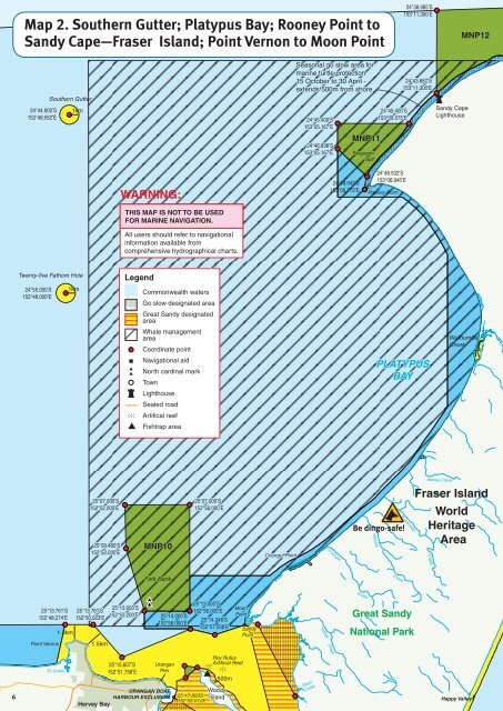
Map 2. Southern Gutter; Platypus Bay; Rooney Point to<br />
<strong>Sandy</strong> Cape—Fraser Island; Point Vernon to Moon Point<br />
24°38.985’S<br />
153°11.300’E<br />
MNP12<br />
24°44.900’S<br />
152°48.552’E<br />
Southern Gutter<br />
1km<br />
Seasonal go slow area for<br />
marine turtle protection<br />
15 October to 30 April -<br />
extends 500m from shore<br />
24°45.400’S<br />
153°05.167’E<br />
24°46.838’S<br />
153°05.167’E<br />
MNP11<br />
Ferguson<br />
Spit<br />
24°45.400’S<br />
153°09.575’E<br />
24°43.687’S<br />
153°11.300’E<br />
<strong>Sandy</strong> Cape<br />
Lighthouse<br />
WARNING:<br />
THIS MAP IS NOT TO BE USED<br />
FOR MARINE NAVIGATION.<br />
All users should refer to navigational<br />
information available from<br />
comprehensive hydrographical charts.<br />
24°48.943’S<br />
153°06.772’E<br />
24°48.502’S<br />
153°06.945’E<br />
Rooney Point<br />
Twenty-five Fathom Hole<br />
Legend<br />
24°55.000’S<br />
152°48.000’E<br />
1km<br />
Commonwealth waters<br />
Go slow designated area<br />
<strong>Great</strong> <strong>Sandy</strong> designated<br />
area<br />
Whale management<br />
area<br />
Coordinate point<br />
Wathumba<br />
Creek<br />
Navigational aid<br />
North cardinal mark<br />
Town<br />
PLATYPUS<br />
BAY<br />
Lighthouse<br />
Sealed road<br />
Artifical reef<br />
Fishtrap area<br />
25°07.000’S<br />
152°52.000’E<br />
25°09.480’S<br />
152°52.000’E<br />
MNP10<br />
25°07.000’S<br />
152°56.000’E<br />
Coongul Point<br />
Coongul<br />
Be dingo-safe!<br />
Woralie<br />
Bowarrady<br />
Awinya Creek<br />
Fraser Island<br />
World<br />
Heritage<br />
Area<br />
Creek<br />
Fork Bank<br />
Creek<br />
25°13.761’S<br />
152°48.274’E<br />
Point Vernon<br />
1.3km<br />
25°13.761’S<br />
152°50.023’E<br />
1.5km<br />
25°13.000’S<br />
152°53.200’E<br />
25°14.000’S<br />
152°56.000’E<br />
25°13.000’S<br />
152°56.000’E<br />
25°14.348’S<br />
152°57.558’E<br />
Moon<br />
Point<br />
<strong>Sandy</strong><br />
Point<br />
Yidney<br />
Creek<br />
Creek<br />
<strong>Great</strong> <strong>Sandy</strong><br />
<strong>National</strong> <strong>Park</strong><br />
6<br />
Eli Creek<br />
Hervey Bay<br />
25°15.607’S<br />
152°51.758’E<br />
Urangan<br />
Pier<br />
URANGAN BOAT<br />
HARBOUR EXCLUSION<br />
Roy Rufus<br />
Artificial Reef<br />
500m<br />
Woody<br />
25 17.893S Island<br />
152 55.012E<br />
Black<br />
Creek<br />
Happy Valley


