

Great Sandy Marine Park Visitor Guide - Department of National ...
Great Sandy Marine Park Visitor Guide - Department of National ...
Great Sandy Marine Park Visitor Guide - Department of National ...

Create successful ePaper yourself
Turn your PDF publications into a flip-book with our unique Google optimized e-Paper software.
Creek<br />
GREGORY<br />
Coonarr<br />
RIVER<br />
ELLIOT<br />
RIVER<br />
Coonar Creek<br />
Weir<br />
Stockyard Creek<br />
Creek<br />
25°09.377’S<br />
152°28.224’E<br />
MNP5<br />
25°09.402’S<br />
152°28.253’E<br />
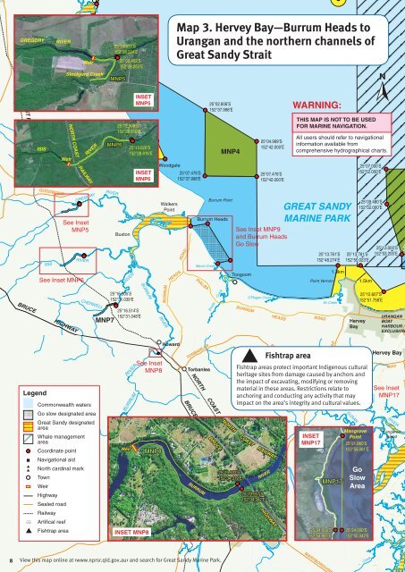
Map 3. Hervey Bay—Burrum Heads to<br />
Urangan and the northern channels <strong>of</strong><br />
<strong>Great</strong> <strong>Sandy</strong> Strait<br />
INSET<br />
MNP5<br />
25°02.806’S<br />
152°37.998’E<br />
WARNING:<br />
NORTH COAST RAILWAY<br />
ISIS<br />
Weir<br />
NORTH COAST<br />
RAILWAY<br />
RIVER<br />
Theodolite Creek<br />
WOODGATE<br />
MNP6<br />
25°12.999’S<br />
152°28.810’E<br />
ROAD<br />
25°13.020’S<br />
152°28.816’E<br />
INSET<br />
MNP6<br />
Woodgate<br />
25°07.476’S<br />
152°37.998’E<br />
MNP4<br />
25°04.999’S<br />
152°42.000’E<br />
25°07.476’S<br />
152°42.000’E<br />
THIS MAP IS NOT TO BE USED<br />
FOR MARINE NAVIGATION.<br />
All users should refer to navigational<br />
information available from<br />
comprehensive hydrographical charts.<br />
25°07.000’S<br />
152°52.000’E<br />
GOODWOOD<br />
ISIS<br />
GREGORY<br />
See Inset<br />
MNP5<br />
RIVER<br />
See Inset MNP6<br />
RIVER<br />
Buxton<br />
RIVER<br />
Walkers<br />
Point<br />
HEADS<br />
ROAD<br />
Burrum Heads<br />
Marsh Creek<br />
Burrum Point<br />
See Inset MNP9<br />
and Burrum Heads<br />
Go Slow<br />
Toogoom<br />
GREAT SANDY<br />
MARINE PARK<br />
25°13.761’S<br />
152°48.274’E<br />
Point Vernon<br />
1.3km<br />
25°13.761’S<br />
152°50.023’E<br />
25°09.480’S<br />
152°52.000’E<br />
1.5km<br />
25°13.000’S<br />
152°53.200’E<br />
BRUCE HIGHWAY<br />
CHERWELL<br />
MNP7<br />
25°16.505’S<br />
152°31.039’E<br />
25°16.514’S<br />
152°31.048’E<br />
BURRUM RIVER<br />
BURRUM<br />
PIALBA<br />
Beelbi<br />
Creek<br />
O’Regan Creek<br />
BURRUM HEADS<br />
ROAD<br />
Eli Creek<br />
Hervey<br />
Bay<br />
25°15.607’S<br />
152°51.758’E<br />
URANGAN<br />
BOAT<br />
HARBOUR<br />
EXCLUSION<br />
Legend<br />
Commonwealth waters<br />
Go slow designated area<br />
<strong>Great</strong> <strong>Sandy</strong> designated<br />
area<br />
Whale management<br />
area<br />
Coordinate point<br />
Navigational aid<br />
North cardinal mark<br />
Town<br />
Weir<br />
Highway<br />
Sealed road<br />
Railway<br />
Artifical reef<br />
Fishtrap area<br />
Weir<br />
RIVER<br />
BURRUM<br />
INSET MNP8<br />
See Inset<br />
MNP8<br />
MNP8<br />
Howard<br />
TORBANLEA<br />
Torbanlea<br />
NORTH COAST<br />
BRUCE HIGHWAY<br />
BURRUM<br />
MARY<br />
BRUCE<br />
NORTH<br />
RAILWAY<br />
25°19.933’S<br />
152°34.319’E<br />
COAST<br />
RAILWAY<br />
RIVER<br />
25°19.957’S<br />
152°34.342’E<br />
PIALBA<br />
Maryborough<br />
Fishtrap area<br />
Fishtrap areas protect important Indigenous cultural<br />
heritage sites from damage caused by anchors and<br />
the impact <strong>of</strong> excavating, modifying or removing<br />
material in these areas. Restrictions relate to<br />
anchoring and conducting any activity that may<br />
impact on the area’s integrity and cultural values.<br />
HIGHWAY<br />
MARYBOROUGH<br />
ROAD<br />
HERVEY BAY<br />
INSET<br />
MNP17<br />
ROAD<br />
RIVER<br />
BOORAL<br />
MNP17<br />
25°24.000’S<br />
152°54.881’E<br />
Brothers<br />
Island<br />
SUSAN<br />
Bunya<br />
Mangrove<br />
Point<br />
25°21.860’S<br />
152°55.061’E<br />
Go<br />
Slow<br />
Area<br />
25°24.000’S<br />
152°55.042’E<br />
Hervey Bay<br />
ROAD<br />
See Inset<br />
MNP17<br />
RIVER<br />
Kangaroo<br />
Island<br />
RIVER<br />
MARYBOROUGH<br />
8<br />
View this map online at and search for <strong>Great</strong> <strong>Sandy</strong> <strong>Marine</strong> <strong>Park</strong>.<br />
Creek<br />
DERM


