

Great Sandy Marine Park Visitor Guide - Department of National ...
Great Sandy Marine Park Visitor Guide - Department of National ...
Great Sandy Marine Park Visitor Guide - Department of National ...

You also want an ePaper? Increase the reach of your titles
YUMPU automatically turns print PDFs into web optimized ePapers that Google loves.
Welcome to<br />
<strong>Great</strong> <strong>Sandy</strong> <strong>Marine</strong> <strong>Park</strong><br />
Access<br />
The <strong>Great</strong> <strong>Sandy</strong> <strong>Marine</strong> <strong>Park</strong> extends from<br />
Baffle Creek in the north to Double Island<br />
Point in the south. It includes Hervey Bay,<br />
<strong>Great</strong> <strong>Sandy</strong> Strait, Tin Can Inlet and the<br />
waters <strong>of</strong>f the east coast <strong>of</strong> Fraser Island,<br />
seaward to three nautical miles.<br />
The park is easily accessed from coastal<br />
towns and boat ramps from Rules Beach<br />
north <strong>of</strong> Bundaberg to Rainbow Beach on<br />
the Cooloola Coast, and from marinas in<br />
Bundaberg, Urangan, and Tin Can Bay.<br />
Management<br />
The <strong>Department</strong> <strong>of</strong> <strong>National</strong> <strong>Park</strong>s,<br />
Recreation, Sport and Racing’s (NPRSR)<br />
Queensland <strong>Park</strong>s and Wildlife Service<br />
(QPWS) manages the <strong>Great</strong> <strong>Sandy</strong><br />
<strong>Marine</strong> <strong>Park</strong>.<br />
The marine park <strong>of</strong>fers a wide range <strong>of</strong><br />
recreational, research and commercial<br />
opportunities. Its tidal lands and marine<br />
waters form a transition zone between<br />
tropical and temperate waters, where<br />
changing water temperatures drive<br />
unique and dynamic life cycles and<br />
influence marine habitats, communities<br />
and wildlife.<br />
Zoning<br />
Conservation—along with the reasonable<br />
use <strong>of</strong> significant marine natural resources<br />
—is achieved through a zoning plan<br />
consisting <strong>of</strong> five zones, nine designated<br />
areas, and a system <strong>of</strong> regulations<br />
and permits.<br />
The zones range from no-take marine<br />
national park zones—green zones—to<br />
general use zones. For more information<br />
see page 3.<br />
What is a designated area?<br />
Designated areas allow for the<br />
management <strong>of</strong> issues that occur<br />
seasonally, such as protection for<br />
migratory shorebirds, whales, marine<br />
turtles and dugong. The purpose and<br />
management provisions <strong>of</strong> designated<br />
areas are in addition to the purpose and<br />
provisions <strong>of</strong> the zones in which the<br />
designated areas are located.<br />
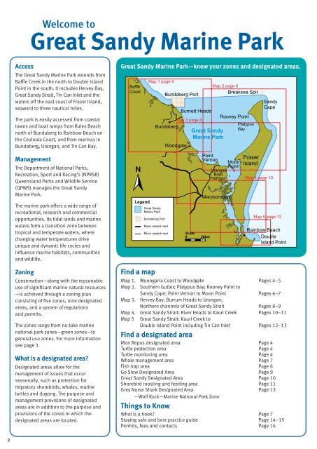
<strong>Great</strong> <strong>Sandy</strong> <strong>Marine</strong> <strong>Park</strong>—know your zones and designated areas.<br />
Baffle<br />
Creek<br />
Legend<br />
Map 1 page 4<br />
<strong>Great</strong> <strong>Sandy</strong><br />
<strong>Marine</strong> <strong>Park</strong><br />
Bundaberg Port<br />
Burnett Heads<br />
Rooney Point<br />
Map 3 page 8<br />
Platypus<br />
Bundaberg<br />
<strong>Great</strong> <strong>Sandy</strong><br />
Bay<br />
<strong>Marine</strong> <strong>Park</strong><br />
Bundaberg Port<br />
Find a map<br />
Major selaed road<br />
Minor sealed road<br />
Woodgate<br />
Point<br />
Vernon<br />
Scale<br />
0 20km<br />
Map 2 page 6<br />
Breaksea Spit<br />
Urangan<br />
Boat<br />
Harbour<br />
Maryborough<br />
Moon<br />
Point<br />
Fraser<br />
Island<br />
<strong>Sandy</strong><br />
Cape<br />
Map 4 page 10<br />
Map 5 page 12<br />
Rainbow Beach<br />
Double<br />
Island Point<br />
Map 1. Woongarra Coast to Woodgate Pages 4–5<br />
Map 2. Southern Gutter; Platypus Bay; Rooney Point to<br />
<strong>Sandy</strong> Cape; Point Vernon to Moon Point Pages 6–7<br />
Map 3. Hervey Bay: Burrum Heads to Urangan;<br />
Northern channels <strong>of</strong> <strong>Great</strong> <strong>Sandy</strong> Strait Pages 8–9<br />
Map 4. <strong>Great</strong> <strong>Sandy</strong> Strait: River Heads to Kauri Creek Pages 10–11<br />
Map 5 <strong>Great</strong> <strong>Sandy</strong> Strait: Kauri Creek to<br />
Double Island Point including Tin Can Inlet Pages 12–13<br />
Find a designated area<br />
Mon Repos designated area Page 4<br />
Turtle protection area Page 4<br />
Turtle monitoring area Page 4<br />
Whale management area Page 7<br />
Fish trap area Page 8<br />
Go Slow Designated Area Page 9<br />
<strong>Great</strong> <strong>Sandy</strong> Designated Area Page 10<br />
Shorebird roosting and feeding area Page 11<br />
Grey Nurse Shark Designated Area Page 13<br />
—Wolf Rock—<strong>Marine</strong> <strong>National</strong> <strong>Park</strong> Zone<br />
Things to Know<br />
What is a hook? Page 7<br />
Staying safe and best practice guide Page 14–15<br />
Permits, fees and contacts Page 16<br />
2


