Appendix 8.1 Flood Risk Assessment - Peel
Appendix 8.1 Flood Risk Assessment - Peel
Appendix 8.1 Flood Risk Assessment - Peel

Create successful ePaper yourself
Turn your PDF publications into a flip-book with our unique Google optimized e-Paper software.
<strong>Peel</strong> Environmental Ltd<br />
<strong>Flood</strong> <strong>Risk</strong> <strong>Assessment</strong> – South Clyde Energy Centre, Glasgow<br />
1 INTRODUCTION<br />
Weetwood were instructed to undertake a <strong>Flood</strong> <strong>Risk</strong> <strong>Assessment</strong> by <strong>Peel</strong><br />
Environmental Ltd in connection with the proposed development of an energy<br />
from waste plant (South Clyde Energy Centre) on a site situated off Bogmoor<br />
Road, Glasgow. The assessment has been prepared in accordance with the<br />
requirements of Scottish Planning Policy (2010) and its supporting guidance<br />
documents including Planning Advice Note 69 (PAN69): Planning and Building<br />
Standards Advice on <strong>Flood</strong>ing. The report has also been prepared with<br />
reference to the <strong>Flood</strong> <strong>Risk</strong> Management (Scotland) Act (2009).<br />
This report is based on studies of relevant detail and consultation with<br />
Glasgow City Council (CC) and the Scottish Environmental Protection Agency<br />
(SEPA). Weetwood has also produced a separate Drainage Impact <strong>Assessment</strong><br />
(DIA) 1 for this site in order to assess any likely impact of the proposals on<br />
surface water runoff.<br />
1.1 SITE LOCATION<br />
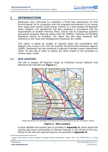
The site is located off Bogmoor Road, at Ordnance Survey National Grid<br />
Reference NS 529 654 (see Figure 1.)<br />
King George V Dock<br />
River Clyde<br />
Hillington Road<br />
Bogmoor Road Site<br />
Bogmoor Road<br />
Johnstone Avenue<br />
Sheildhall Road (A8)<br />
Railway Line<br />
M8<br />
Image reproduced with permission of Ordnance Survey and Ordnance Survey of Northern Ireland<br />
Figure 1: Site Location<br />
A more detailed site location plan is provided in <strong>Appendix</strong> A, which shows the<br />
existing site layout and location of relevant features in the vicinity of the site.<br />
Photos of the site and relevant features are provided in <strong>Appendix</strong> B.<br />
1 “South Clyde Energy Centre, Glasgow: Drainage Impact <strong>Assessment</strong>”, Report. Ref: 1727 SCEC/DIAv2.1, 14 May<br />
2012<br />
©Weetwood<br />
www.weetwood.net<br />
1 1727 SCEC/FRA_Final v2.1<br />
14 May 2012