Appendix 8.1 Flood Risk Assessment - Peel
Appendix 8.1 Flood Risk Assessment - Peel
Appendix 8.1 Flood Risk Assessment - Peel

You also want an ePaper? Increase the reach of your titles
YUMPU automatically turns print PDFs into web optimized ePapers that Google loves.
<strong>Peel</strong> Environmental Ltd<br />
<strong>Flood</strong> <strong>Risk</strong> <strong>Assessment</strong> – South Clyde Energy Centre, Glasgow<br />
2 SCOTTISH PLANNING POLICY<br />
2.1 SCOTTISH ENVIRONMENT PROTECTION AGENCY FLOOD MAP<br />
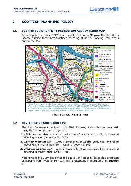
According to the latest SEPA flood map for this area (Figure 2), the site is<br />
located outside those areas defined as being at risk of flooding from rivers<br />
and/or the sea.<br />
Figure 2: SEPA <strong>Flood</strong> Map<br />
2.2 DEVELOPMENT AND FLOOD RISK<br />
The <strong>Risk</strong> Framework outlined in Scottish Planning Policy defines flood risk<br />
using the following three categories:<br />
1. Little or no risk – Annual probability of watercourse, tidal or coastal<br />
flooding is less than 0.1% (1:1000)<br />
2. Low to medium risk – Annual probability of watercourse, tidal or coastal<br />
flooding is in the range 0.1% - 0.5% (1:1000 – 1:200)<br />
3. Medium to high risk – Annual probability of watercourse, tidal or coastal<br />
flooding is greater than 0.5% (1:200)<br />
According to the SEPA flood map the site is considered to be at little or no risk<br />
of flooding from rivers and/or sea. This is discussed in more detail in Section<br />
3.<br />
©Weetwood<br />
www.weetwood.net<br />
3 1727 SCEC/FRA_Final v2.1<br />
14 May 2012