GUIDELINE - NSW Rural Fire Service
GUIDELINE - NSW Rural Fire Service
GUIDELINE - NSW Rural Fire Service

You also want an ePaper? Increase the reach of your titles
YUMPU automatically turns print PDFs into web optimized ePapers that Google loves.
Veg Category 1 polygons shall be coloured solid orange without a borderline.<br />
Veg Category 2 polygons shall be coloured solid yellow without a borderline.<br />
Bush <strong>Fire</strong> Vegetation Buffer polygon objects shall be coloured solid red without a<br />
borderline.<br />
Schedule 1 shows examples of the Bushfire Prone Land Map. Their specifications<br />
follow in the methodology.<br />
6.2 Format<br />
When Councils send bush fire prone land and property map layers to the <strong>Service</strong> the<br />
data must be in accordance with the following:<br />
Bushfire Prone Land Map<br />
(a)<br />
(b)<br />
(c)<br />
(d)<br />
(e)<br />
(f)<br />
One data set is required, consisting of the Vegetation Categories and<br />
Buffer;<br />
Designated Bush <strong>Fire</strong> Prone Property may be provided as an additional<br />
depiction layer.<br />
Data shall be in MapInfo tab format (preferred), ArcView shape or<br />
MapInfo mid/mif<br />
The data shall include all attached files that are required for display and<br />
storage of the data. Eg. MapInfo tab file including .tab/.dat/.id/.map/.ind<br />
All data provided should utilise Projection GDA 94 or clearly identify<br />
projection used in the meta-data statement.<br />
The data must not be password protected or locked in any way that<br />
denies the <strong>Service</strong> full and complete access to the data.<br />
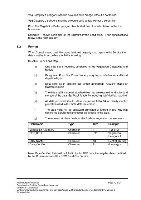
(g) The required attribute fields for the Bushfire vegetation dataset are: -<br />
Field Name Type Size Example<br />
Vegetation_Category Character 1 1, 2, or 3<br />
BFP_CAT BFP_DESC Character 32 Vegetation<br />
Category 1<br />
LGA_NAME Character 50 Central_Darling<br />
Date_Certified Character 8 ddmmyyyy<br />
Note: Date Certified Field will be filled in by the RFS once the map has been certified<br />
by the Commissioner of the <strong>NSW</strong> <strong>Rural</strong> <strong>Fire</strong> <strong>Service</strong>.<br />
<strong>NSW</strong> <strong>Rural</strong> <strong>Fire</strong> <strong>Service</strong> Page 10 of 24<br />
Guideline for Bushfire Prone Land Mapping<br />
Version 3 – June 2006<br />
G:\Community Safety\Development Control <strong>Service</strong>s\Policies and Standards\Guidelines\Guideline for BPM Version 3<br />
(formatted).doc