GUIDELINE - NSW Rural Fire Service
GUIDELINE - NSW Rural Fire Service
GUIDELINE - NSW Rural Fire Service

Create successful ePaper yourself
Turn your PDF publications into a flip-book with our unique Google optimized e-Paper software.
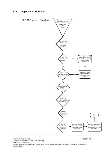
10.2 Appendix 3 - Flowchart<br />
BFPLM Process - Flowchart<br />
Development Control<br />
(DCS) receive digital<br />
data set and letters from<br />
Council and<br />
RFS<br />
District.<br />
Map reviewed<br />
by DCS to<br />
ensure all<br />
information<br />
provided.<br />
Is all<br />
information<br />
supplied?<br />
No<br />
Referred back to RFS<br />
District and Council for<br />
negotiation regarding<br />
annomalies and<br />
classifications<br />
Yes<br />
Yes<br />
Satisfied that all<br />
amendments meet<br />
guidelines criteria.<br />
Yes<br />
Clarification and/or<br />
additional details<br />
received by RFS -<br />
DCS<br />
Data provided to<br />
RFS GIS<br />
Processing<br />
timeframe of 28 days<br />
commences<br />
Completed<br />
Map returned<br />
to DCS<br />
End<br />
Map to<br />
Commissioner<br />
of RFS for<br />
Certification<br />
RFS GIS to make<br />
digital data available<br />
to DCS via certified<br />
data folder.<br />
Hardcopy of Maps and<br />
re-certified data resupplied<br />
to Council and<br />
RFS district.<br />
<strong>NSW</strong> <strong>Rural</strong> <strong>Fire</strong> <strong>Service</strong> Page 24 of 24<br />
Guideline for Bushfire Prone Land Mapping<br />
Version 3 – June 2006<br />
G:\Community Safety\Development Control <strong>Service</strong>s\Policies and Standards\Guidelines\Guideline for BPM Version 3<br />
(formatted).doc