GUIDELINE - NSW Rural Fire Service
GUIDELINE - NSW Rural Fire Service
GUIDELINE - NSW Rural Fire Service

You also want an ePaper? Increase the reach of your titles
YUMPU automatically turns print PDFs into web optimized ePapers that Google loves.
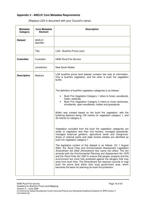
Appendix 2 - ANZLIC Core Metadata Requirements<br />
(Replace LGA in document with your Council’s name).<br />
Metadata<br />
Category<br />
Core Metadata<br />
Element<br />
Description<br />
Dataset<br />
ANZLIC<br />
Identifier<br />
Title<br />
LGA - Bushfire Prone Land<br />
Custodian<br />
Custodian<br />
<strong>NSW</strong> <strong>Rural</strong> <strong>Fire</strong> <strong>Service</strong><br />
Jurisdiction<br />
New South Wales<br />
Description<br />
Abstract<br />
LGA bushfire prone land dataset contains two sets of information.<br />
One is bushfire vegetation, and the other is bush fire vegetation<br />
buffer.<br />
The definition of bushfire vegetation categories is as follows:<br />
• Bush <strong>Fire</strong> Vegetation Category 1 refers to forest, woodlands,<br />
heath, wetlands<br />
• Bush <strong>Fire</strong> Vegetation Category 2 refers to moist rainforests,<br />
shrublands, open woodlands, mallee and grasslands<br />
Buffer was created based on the bush fire vegetation, with the<br />
buffering distance being 100 metres for vegetation category 1, and<br />
30 metres for category 2.<br />
Vegetation excluded from the bush fire vegetation categories are<br />
areas of vegetation less than one hectare, managed grasslands,<br />
managed botanical gardens, agricultural lands and mangroves.<br />
Areas of national parks and state forests estates are identified as<br />
bush fire vegetation category 1.<br />
The legislative context of this dataset is as follows. On 1 August<br />
2002, the <strong>Rural</strong> <strong>Fire</strong>s and Environmental Assessment Legislation<br />
Amendment Act 2002 (Amendment Act) came into effect. The Act<br />
amends both the Environmental Planning and Assessment Act 1979<br />
and the <strong>Rural</strong> <strong>Fire</strong>s Act 1997 to ensure that people, property and the<br />
environment are more fully protected against the dangers that may<br />
arise from bush fires. The Amendment Act requires councils to map<br />
bush fire prone land within their local government area, which<br />
becomes the basis for planning for bush fire protection.<br />
<strong>NSW</strong> <strong>Rural</strong> <strong>Fire</strong> <strong>Service</strong> Page 19 of 24<br />
Guideline for Bushfire Prone Land Mapping<br />
Version 3 – June 2006<br />
G:\Community Safety\Development Control <strong>Service</strong>s\Policies and Standards\Guidelines\Guideline for BPM Version 3<br />
(formatted).doc