

Regional Bicycle, Pedestrian, and Trails Master Plan - sacog
Regional Bicycle, Pedestrian, and Trails Master Plan - sacog
Regional Bicycle, Pedestrian, and Trails Master Plan - sacog

Create successful ePaper yourself
Turn your PDF publications into a flip-book with our unique Google optimized e-Paper software.
<strong>Master</strong> <strong>Plan</strong> <strong>Bicycle</strong>, <strong>Pedestrian</strong>, <strong>and</strong> <strong>Trails</strong> 19<br />
Goal 3:<br />
Improve bicycle <strong>and</strong> pedestrian safety.<br />
Strategies:<br />
3.A: Create a safe environment for bicycle <strong>and</strong> pedestrian travel at intersections <strong>and</strong> street<br />
crossings.<br />
3.B: Promote complete streets <strong>and</strong> application of context-sensitive complete streets treatments,<br />
including constructing <strong>and</strong> retrofitting new <strong>and</strong> existing facilities <strong>and</strong> networks to<br />
increase bicyclist <strong>and</strong> pedestrian safety, <strong>and</strong> separating motorist, bicycle, <strong>and</strong> pedestrian<br />
facilities from each other to reduce conflicts through appropriate designs, when necessary.<br />
3.C: Increase support of bicycling <strong>and</strong> walking as travel modes through treatments such as<br />
street signage, median refuge isl<strong>and</strong>s, dynamic lighting, traffic calming devices, <strong>and</strong> feedbacks<br />
signs, especially in congested areas such as school zones, central business districts,<br />
activity centers <strong>and</strong> high volume bicycle/pedestrian/automobile roadways <strong>and</strong> networks.<br />
3.D: Increase coordination with law enforcement to create safe environments for bicycling <strong>and</strong><br />
walking using a variety of resources available (e.g., enhanced enforcement of traffic laws,<br />
feedback signs), especially around schools <strong>and</strong> other high bicycle <strong>and</strong> pedestrian traffic<br />
areas.<br />
Actions:<br />
i<br />
ii<br />
iii<br />
iv<br />
Take steps to improve safety <strong>and</strong> security at crosswalks, transit stops, <strong>and</strong> along main access<br />
routes to transit, including rural areas, with higher priority for low income, minority,<br />
<strong>and</strong> high crime areas. (MTP Policy 20 Strategy 3)<br />
Continue to identify best practices for complete streets, continue to add to the Complete<br />
Streets Toolkit, <strong>and</strong> initiate a technical assistance program to help local agencies develop<br />
street designs that are sensitive to their surroundings <strong>and</strong> context. Provide technical<br />
support as resources allow. (informed by MTP Policy 3 Strategy 2)<br />
Promote the use of safety information (e.g. SWITRS) to jurisdictions working to identify<br />
trouble areas in need of safety-enhancing improvements.<br />
Help local agencies get funding from specific safety programs for safety <strong>and</strong> security<br />
improvements. (MTP Policy 14 Strategy 4)<br />
DD-64 Statewide Complete Streets<br />
Implementation<br />
Caltrans Deputy Directive 64-R1 requires<br />
projects to consider all users of the<br />
transportation system to ensure that people<br />
of all ages <strong>and</strong> abilities can travel along<br />
<strong>and</strong> across a network of complete streets.<br />
Incorporating bicycle <strong>and</strong> pedestrian<br />
improvements into regular planning <strong>and</strong><br />
rehabilitation projects is an important step<br />
towards creating the network described<br />
by Caltrans. In 2010, Caltrans developed<br />
a Complete Streets Implementation<br />
<strong>Plan</strong>, which is now available at<br />
http://www.dot.ca.gov<br />
Walk Audits<br />
To identify barriers that prevented kids from<br />
walking or biking to school, Sacramento<br />
County partnered with WALKSacramento<br />
to promote biking <strong>and</strong> walking events at<br />
the schools, draft a Safe Routes to School<br />
toolkit, <strong>and</strong> conduct walkability <strong>and</strong><br />
bikeability audits helping to identify many<br />
infrastructure improvements that increase<br />
safety around schools.<br />
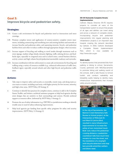
In the city of Sacramento, the<br />
Bannon Creek Elementary Safe<br />
Routes to School project, at the<br />
intersection of Millcreek Dr.<br />
<strong>and</strong> West El Camino Blvd,<br />
resulted in many infrastructure<br />
improvements to increase the<br />
safety of non-motorized travel.<br />
Bulb-outs reduce the pedestrian<br />
crossing distance, a pedestrian<br />
countdown tells how much time<br />
remains to cross the street, <strong>and</strong><br />
the installation of a stoplight<br />
(with bicycle detection) <strong>and</strong> stop<br />
bars provide amenities walkers<br />
<strong>and</strong> bikers need.<br />
Photo courtesy of WALKSacramento


