<strong>Desert</strong> <strong>Research</strong> <strong>Institute</strong> Division of Earth & Ecosystem Sciences (DEES) Landscape Dynamics Support Program (LanDPro) Meeting military readiness, mission capability, and battlefield preparation calls for large training areas in landscapes representative of the in-theater field environment. Access to safe and realistic training necessitates training area sustainability through land and cultural resource management, as well as the ability to predict and avoid areas sensitive to disturbance. Cost-effective, system-wide methodologies based on integrated scientific approaches for rapid site assessment can minimize disruptions to training, while fulfilling management strategies. LanDPro enhances and integrates recently completed soil, geomorphic, and hydrogeologic projects for ITAM and other DoD projects, as well as improves the robustness and universality of existing tools in support of use these tools to selectively assess and target sites for restoration and resource management. Additionally, expedited cultural resource inventories for DoD expansion areas or infrastructure modifications will be possible through enhancement of existing prototypes for predictive archaeological models. Photos: Sara E. Jenkins Related <strong>Research</strong> Sponsored in part by the Department of Defense Bullard, T., McDonald, E., and Baker, S. 2009. Integration of new methods in soils and geomorphology applied to cultural resources management on military lands. Workshop Report, sponsored by: Army <strong>Research</strong> Office, NAVFAC SW, <strong>Desert</strong> <strong>Research</strong> <strong>Institute</strong>, Oct. 20-22, San Diego, CA. Caldwell, T.G., McDonald, E.V. and Young, M. 2006. Soil disturbance and hydrologic response at the National Training Center, Ft. Irwin, California. Journal of Arid Environments, 67, p. 456-472. McDonald, E.V., and Bullard, T.F. 2008. Geomorphic response to extreme change in a Mediterranean ecosystem: Holocene alluvial history of Santa Catalina Island, California, USA. European Geosciences Union, Geophysical <strong>Research</strong> Abstracts 10, EGU2008-A-10709. McDonald, E., Bullard, T., Britt, T., and Ruiz, M. 2004. Development of an archaeological predictive model for management of military lands: identification of geological variables in desert terrain. In: D.R. Caldwell, J. Ehlen, and R.S. Harmon, Eds., Studies in Military Geology. Kluwer Academic, Boston, p. 259-270.
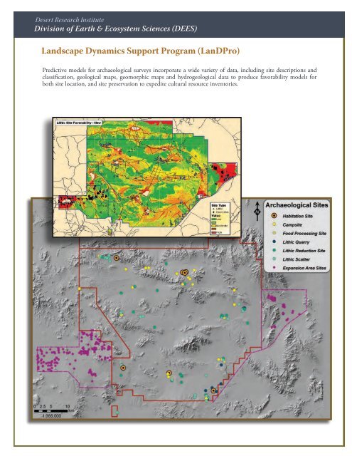
<strong>Desert</strong> <strong>Research</strong> <strong>Institute</strong> Division of Earth & Ecosystem Sciences (DEES) Landscape Dynamics Support Program (LanDPro) Predictive models for archaeological surveys incorporate a wide variety of data, including site descriptions and classification, geological maps, geomorphic maps and hydrogeological data to produce favorability models for both site location, and site preservation to expedite cultural resource inventories.