

Download PDF - Desert Research Institute
Download PDF - Desert Research Institute
Download PDF - Desert Research Institute

You also want an ePaper? Increase the reach of your titles
YUMPU automatically turns print PDFs into web optimized ePapers that Google loves.
<strong>Desert</strong> <strong>Research</strong> <strong>Institute</strong><br />
Division of Earth & Ecosystem Sciences (DEES)<br />
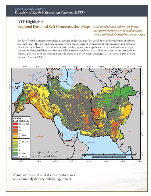
DTF Highlight:<br />
Regional Dust and Salt Concentration i Maps<br />
Air Force <strong>Research</strong> Laboratory Project<br />
in support of prevention of sand induced<br />
circuit card and electrical system corrosion<br />
Products from this project are intended to advance understanding of the distribution and composition of airborne<br />
dust and sand. This dust and sand appears to be a major source of environmental contamination and corrosion<br />
of aircraft circuit boards. The primary initiative of this project - see map, below - is the production of strategicscale<br />
maps of potential dust and associated salt emission in southwest Asia. Emission estimates are derived from<br />
regional projections of soil type and content, based in part on work conducted at U.S. Army Yuma Proving<br />
Ground, Arizona, USA.<br />
35°0'0"E<br />
40°0'0"E<br />
45°0'0"E<br />
50°0'0"E<br />
55°0'0"E<br />
60°0'0"E<br />
65°0'0"E<br />
70°0'0"E<br />
75°0'0"E<br />
80°0'0"E<br />
Turkey<br />
Georgia Georgia<br />
Armenia<br />
Azerbaijan<br />
Kazakhstan<br />
Kazakhstan<br />
Uzbekistan<br />
Kazakhstan<br />
Kyrgyzstan<br />
40°0'0"N<br />
Turkmenistan<br />
Tajikistan<br />
China<br />
35°0'0"N<br />
Cyprus<br />
Caspian Sea<br />
Mediterranean<br />
Sea<br />
Lebanon<br />
Syria<br />
35°0'0"N<br />
West Bank<br />
Gaza Strip<br />
Iraq<br />
Afghanistan<br />
30°0'0"N<br />
Israel Jordan<br />
Egypt<br />
Iran<br />
30°0'0"N<br />
MAP UNIT<br />
Dust & Salt Potential<br />
Kuwait<br />
Pakistan<br />
12<br />
Very High<br />
25°0'0"N<br />
11<br />
10<br />
9<br />
8<br />
High<br />
Saudi Arabia<br />
Qatar<br />
Arabian - Persian Gulf<br />
India<br />
25°0'0"N<br />
Egypt<br />
7<br />
6<br />
Moderate<br />
United Arab Emirates<br />
Gulf of Oman<br />
20°0'0"N<br />
Sudan<br />
5<br />
4<br />
3<br />
0<br />
Low<br />
Water<br />
Composite Dust &<br />
Salt Potential Map<br />
Oman<br />
0 100<br />
200 400 600 800 1,000<br />
0 100 200 400 600 800 1,000<br />
Kilometers<br />
Miles<br />
20°0'0"N<br />
Eritrea<br />
40°0'0"E<br />
45°0'0"E<br />
50°0'0"E<br />
55°0'0"E<br />
60°0'0"E<br />
65°0'0"E<br />
70°0'0"E<br />
75°0'0"E<br />
COMPOSITE DUST & SALT POTENTIAL MAP BASED ON LANDFORMS,<br />
PRECIPITATION & GEOLOGY OF A PORTION OF SOUTHWEST ASIA<br />
Abundant dust and sand decrease performance<br />
and commonly damage military equipment


