

Download PDF - Desert Research Institute
Download PDF - Desert Research Institute
Download PDF - Desert Research Institute

You also want an ePaper? Increase the reach of your titles
YUMPU automatically turns print PDFs into web optimized ePapers that Google loves.
<strong>Desert</strong> <strong>Research</strong> <strong>Institute</strong><br />
Division of Earth & Ecosystem Sciences (DEES)<br />
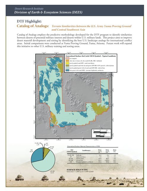
DTF Highlight:<br />
Catalog of Analogs:<br />
Terrain Similarities between the U.S. Army Yuma Proving Ground<br />
and Central Southwest Asia<br />
Catalog of Analogs employs the predictive methodology developed for the DTF program to identify similarities<br />
desert materiél development and testing by identifying the best U.S. landscape analogs for international conflict<br />
areas. Initial comparisons were conducted at Yuma Proving Ground, Yuma, Arizona. Future work will expand<br />
this initiative to other U.S. military training and testing areas.<br />
114°30'0"W<br />
114°20'0"W<br />
114°10'0"W<br />
114°0'0"W<br />
113°50'0"W<br />
113°40'0"W<br />
33°30'0"N<br />
Generalized Surface Soil [with USCS Symbol] - Typical Landform<br />
not mapped<br />
silty clay to clayey silt; silty sand [CL-ML; SM] - badlands<br />
poorly graded sand [SP] - sand seas/dunes<br />
poorly graded sand with silt and gravel [SP-SM (>15% gravel)] - alluvial plains<br />
poorly graded gravel with silt and sand [GP-GM] - alluvial fans<br />
silty gravel with sand [GM] - mountain highlands, pediments<br />
32°50'0"N<br />
32°50'0"N<br />
33°0'0"N<br />
33°0'0"N<br />
33°10'0"N<br />
33°10'0"N<br />
33°20'0"N<br />
33°20'0"N<br />
33°30'0"N<br />
32°40'0"N<br />
0 5 10<br />
Miles<br />
0 5 10<br />
Kilometers<br />
32°40'0"N<br />
114°30'0"W<br />
114°20'0"W<br />
114°10'0"W<br />
114°0'0"W<br />
113°50'0"W<br />
113°40'0"W<br />
GM<br />
28.5%<br />
CL-ML; SM<br />
1.4%<br />
SP<br />
0.2%<br />
SP-SM<br />
8.4%<br />
Generalized Surface Material Characteristics of YPG<br />
Soil<br />
[USCS Symbol]<br />
Landform(s) Area Area Area<br />
(mi 2 ) (km 2 ) (%)<br />
CL-ML; SM<br />
SP<br />
SP-SM<br />
GP-GM<br />
GM<br />
Badlands<br />
Sand seas/dunes<br />
Alluvial plains<br />
Alluvial fans<br />
Mountain highlands, pediments<br />
18.3<br />
2.5<br />
110.2<br />
805.1<br />
373.1<br />
47.4<br />
6.4<br />
285.5<br />
2,085.2<br />
966.3<br />
1.4<br />
0.2<br />
8.4<br />
61.5<br />
28.5<br />
GP-GM<br />
61.5%<br />
SURFACE SOILS IN YPG<br />
(total area = ~1,300 sq mi (~3,400 sq km))


